

InVEST Model considering terrain and biodiversity and its application in the analysis of county biodiversity security pattern: a case study of Wengyuan County
-
摘要:
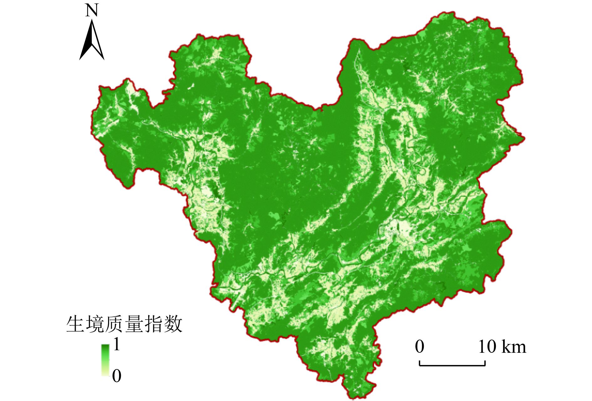
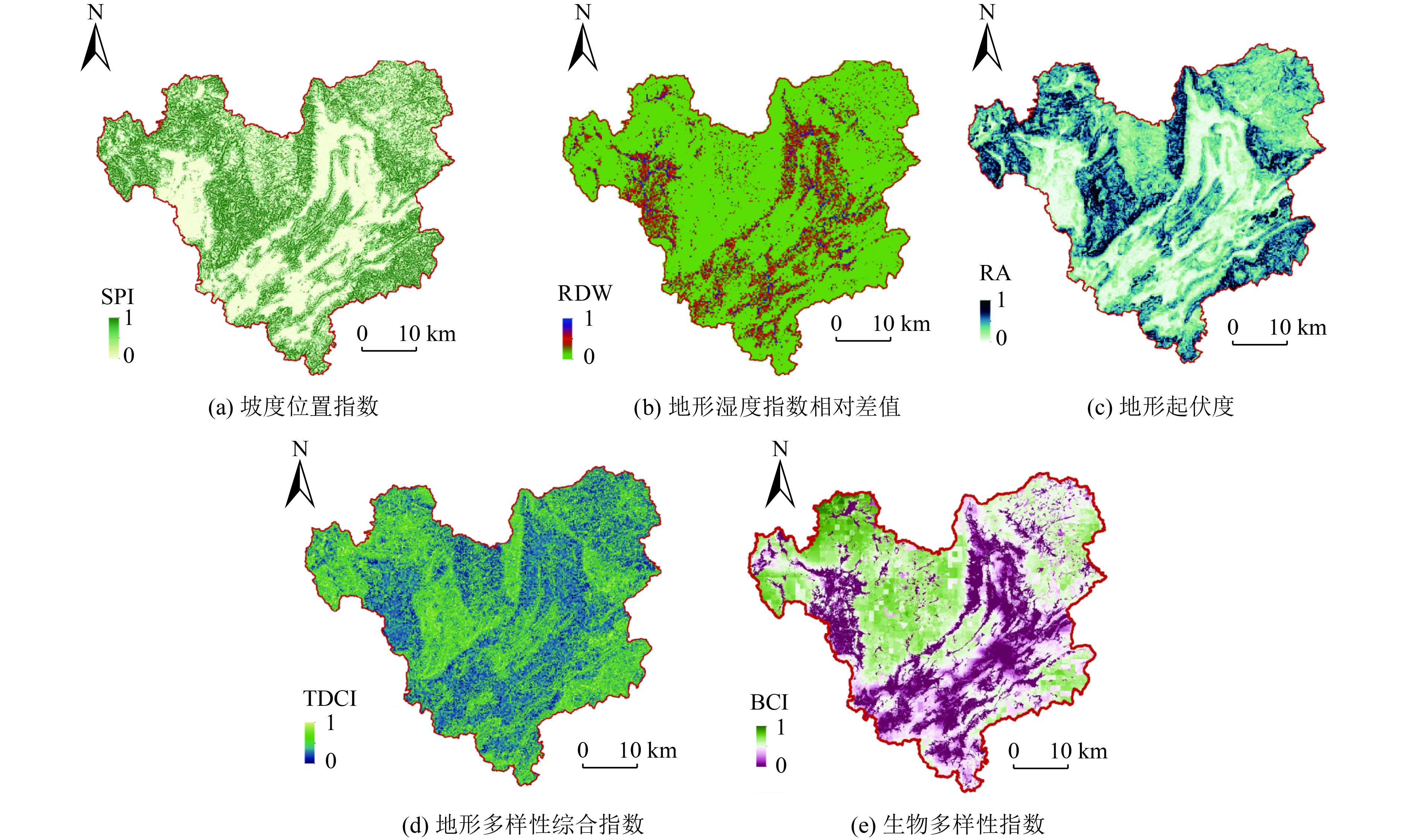
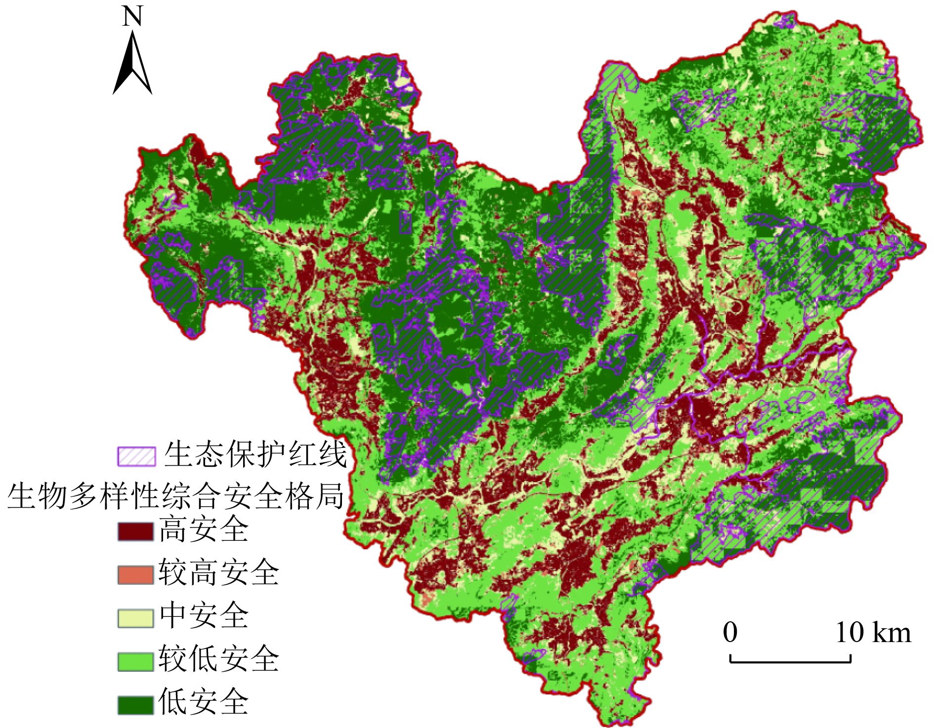
县域尺度生物多样性安全格局精细评估可为区域生物多样性保护规划、实施与管理提供科学参考。以粤北山区翁源县为例,采用InVEST生境质量模型,结合区域地形与生物多样性特征,以生境质量指数、地形与生物多样性综合指数为评价指标,开展区域生物多样性安全格局综合评估。结果表明:翁源县整体生境质量指数(HQI)较高,尤其在人为扰动较弱的水系和林区最为明显,生境质量指数较低区集中在建设用地、耕地等人类活动影响强烈区域;地形多样性综合指数(TDCI)与地形起伏度和地形坡度位置指数分布格局较为一致,而与地形湿度指数相对差值分布格局相反;生物多样性指数(BCI)分布格局受到香农-威纳指数物种多样性本底及生物多样性丰富度、人类足迹指数、生物多样性重要度与植被总覆盖度的交互影响;生物多样性综合安全格局指数与HQI、BCI及TDCI分布有较好的一致性,低风险/低脆弱(高安全)区集中在县域内城镇建设用地、交通水利和耕地等人类活动强烈区,高风险/高脆弱(低安全)区主要分布在县域北部、西北部、东南部、东北部自然保护和饮用水源等人类活动干扰微弱区。通过与区域生态保护红线等相关资料进行验证与分析,改进优化后的评估结果更能精细和客观地反映研究区生物多样性安全格局。
-
关键词:
- InVEST生境质量模型 /
- 生物多样性综合指数 /
- 地形多样性综合指数 /
- 生物多样性安全格局 /
- 翁源县
Abstract:Detailed assessment of the county-level biodiversity security pattern can provide scientific reference for the planning, implementation and management of regional biodiversity conservation. Taking Wengyuan County in the mountainous area of Northern Guangdong Province as an example, InVEST habitat quality model was used to achieve a comprehensive assessment of the regional biodiversity security pattern, by combining with regional topography and biodiversity characteristics and applying the habitat quality index and the composite topography and biodiversity index as evaluation indicators. The results showed that the overall habitat quality index (HQI) of Wengyuan County was good, especially in the river system and forest areas with weak anthropogenic disturbance, and the areas with low HQI were concentrated in the those strongly influenced by human activities such as construction land and cultivated land. The distribution pattern of topographic diversity composite index (TDCI) was consistent with that of relief amplitude (RA) and slope position index (SPI), but opposite to that of the relative difference of topographic wetness index (RDW). The distribution pattern of biodiversity composite index (BCI) was affected by the interaction between species diversity background in Shannon-Wiener index (H') and biodiversity richness (BR), human footprint index (HF), biodiversity significance (BS) and total vegetation coverage. The distribution of biodiversity security pattern index (BSPI) was well consistent with that of HQI, BCI and TDCI. Low-risk/low-vulnerability areas were concentrated in the county areas with strong human activities, such as urban construction land, transportation and water conservancy, and cultivated land. High-risk/high-vulnerability areas were mainly distributed in the areas with weak anthropogenic disturbances, such as nature protection and drinking water sources in the north, northwest, southeast and northeast of Wengyuan County. Through the verification and analysis of the relevant data such as the ecological protection redline, it was shown that the improved and optimized evaluation results could reflect the biodiversity security pattern of the study area more precisely and objectively.
-

图 4 生物多样性综合安全格局及生态保护红线
Figure 4. Comprehensive biodiversity security pattern and ecological conservation redline
表 1 威胁源及其相对权重和最大影响距离
Table 1. Threat sources and their relative weights and maximum impact distances
威胁源 相对权重 最大影响距离/km 城镇用地 0.8 2 农村用地 0.6 1 耕地 0.3 0.5 铁路 0.4 0.6 主要公路 0.4 0.7 工矿用地 1 2.5  下载: 导出CSV
表 2 生境适宜度及其对威胁源的相对敏感度
Table 2. Habitat suitability and its relative sensitivity to threat sources
生态系统类型 地类 生境适宜度 生境对各威胁源的敏感性 城镇用地 农村用地 耕地 铁路 主要公路 工矿用地 农田生态系统 耕地 0.5 0.5 0.3 0 0.4 0.3 0.8 森林生态系统 林地 1 0.8 0.65 0.5 0.6 0.7 0.9 绿地 0.8 0.7 0.5 0.35 0.55 0.5 0.8 陆域自然保留地 1 0.8 0.65 0.5 0.6 0.7 0.9 园地 0.7 0.6 0.45 0.35 0.6 0.65 0.8 草地生态系统 牧草地 0.7 0.7 0.5 0.35 0.55 0.5 0.8 湿地生态系统 陆地水域 0.8 0.75 0.6 0.4 0.55 0.5 0.8 湿地 1 0.75 0.55 0.4 0.6 0.7 0.9 人工生态系统 居住用地 0.1 0 0 0 0 0 0 广场用地 0.1 0 0 0 0 0 0 商业服务业
设施用地0 0 0 0 0 0 0 公共管理与公共服务设施用地 0 0 0 0 0 0 0 区域基础
设施用地0 0 0 0 0 0 0 仓储用地 0 0 0 0 0 0 0 道路与交通
设施用地0 0 0 0 0 0 0 工业用地 0 0 0 0 0 0 0 采矿盐田用地 0 0 0 0 0 0 0 公共设施用地 0 0 0 0 0 0 0 其他 其他农用地 0.2 0.2 0 0 0.1 0.1 0.3 特殊用地 0.1 0.2 0 0 0.1 0.1 0.3
下载: 导出CSV
表 3 生物多样性综合安全格局分布面积统计
Table 3. Statistics on the distribution area of comprehensive biodiversity security pattern
安全格局 面积/hm2 面积占比/% 生态保护红线内占比/% 高安全 31 171.77 14.35 0.21 较高安全 6 701.94 3.09 0.22 中安全 27 643.77 12.73 2.89 较低安全 70 503.12 32.47 25.37 低安全 81 135.18 37.36 71.32 总计 217 155.78 100 100
下载: 导出CSV
-
[1] 蒋志刚, 马克平.保护生物学的现状、挑战和对策[J]. 生物多样性,2009,17(2):107-116. doi: 10.3724/SP.J.1003.2009.08279JIANG Z G, MA K P. Status quo, challenges and strategy in Conservation Biology[J]. Biodiversity Science,2009,17(2):107-116. doi: 10.3724/SP.J.1003.2009.08279 [2] 任海, 郭兆晖.中国生物多样性保护的进展及展望[J]. 生态科学,2021,40(3):247-252.REN H, GUO Z H. Progress and prospect of biodiversity conservation in China[J]. Ecological Science,2021,40(3):247-252. [3] 钱云, 翁丽珠, 于长明, 等. 基于景观生态网络方法的市域生物多样性保护研究: 以晋中市为例[J]. 中国园林, 2015, 31(10): 86-90.QIAN Y, WENG L Z, YU C M, et al. Study on city-wide biodiversity protection based on landscape ecological network: taking Jinzhong as an example[J]. Chinese Landscape Architecture,2015, 31(10): 86-90. [4] ZHAO X Q, XU X H. Research on landscape ecological security pattern in a Eucalyptus introduced region based on biodiversity conservation[J]. Russian Journal of Ecology,2015,46(1):59-70. doi: 10.1134/S106741361501018X [5] HUDSON L N, NEWBOLD T, CONTU S, et al. The database of the PREDICTS (Projecting Responses of Ecological Diversity In Changing Terrestrial Systems) project[J]. Ecology and Evolution,2017,7(1):145-188. doi: 10.1002/ece3.2579 [6] IUCN, Bird Life International And UNEP-WCMC. "Biodiversity importance": accessed from Global Forest Watch on 11/12/2020[Z]. (2023-06-09)[2022-08-09]www.globalforestwatch.org. [7] HILL S, GONZALEZ R, SANCHEZ-ORTIZ K, et al. Worldwide impacts of past and projected future land-use change on local species richness and the Biodiversity Intactness Index[J]. Cold Spring Harbor Laboratory, 2018,311787.. [8] UNEP-WCMC. Human pressures on biodiversity, water and carbon[Z]. Cambridge, UK: UNEP-WCMC, 2020. https://doi.org/10.34892/ykjb-c787. [9] 马克明, 张洁瑜, 郭旭东, 等.农业景观中山体的植物多样性分布: 地形和土地利用的综合影响[J]. 植物生态学报,2002,26(5):575-588.MA K M, ZHANG J Y, GUO X D, et al. Plant diversity distribution of mountains in rural landscapes: the combined influences of topography and land use[J]. Acta Phytoecologica Sinica,2002,26(5):575-588. [10] DILLON K G, CONWAY C J. Habitat heterogeneity, temperature, and primary productivity drive elevational gradients in avian species diversity[J]. Ecology and Evolution,2021,11(11):5985-5997. doi: 10.1002/ece3.7341 [11] AL-SABABHAH N. Topographic position index to landform classification and spatial planning, using GIS, for Wadi Araba, South West Jordan[J]. Environment and Ecology Research. 2023, 11(1): 79-101. [12] ZHANG S, CHEN W, HUANG J, et al. Orchid species richness along elevational and environmental gradients in Yunnan, China[J]. PLoS ONE,2015,10(11):e142621. [13] RAHBEKTHE C. Relationship among area, elevation, and regional species richness in neotropical birds[J]. Ecography (Copenhagen),2004,27(5):545. doi: 10.1111/j.0906-7590.2004.04098.x [14] 刘秉儒.生物多样性的海拔分布格局研究及进展[J]. 生态环境学报,2021,30(2):438-444.LIU B R. Recent advances in altitudinal distribution patterns of biodiversity[J]. Ecology and Environmental Sciences,2021,30(2):438-444. [15] QUINN P F, BEVEN K J, LAMB R. The in(a/tan/β) index: how to calculate it and how to use it within the topmodel framework[J]. Hydrological Processes,1995,9(2):161-182. doi: 10.1002/hyp.3360090204 [16] 马伟波, 赵立君, 田佳榕, 等.基于地形位置指数的赤水河流域植被时空变化研究[J]. 环境科学研究,2020,33(12):2705-2712.MA W B, ZHAO L J, TIAN J R, et al. Spatiotemporal changes of vegetation in Chishui River Basin based on topographic position index[J]. Research of Environmental Sciences,2020,33(12):2705-2712. [17] ALSTERBERG C, ROGER F, SUNDBACK K, et al. Habitat diversity and ecosystem multifunctionality: the importance of direct and indirect effects[J]. Science Advances,2017,3(2):e1601475. doi: 10.1126/sciadv.1601475 [18] JOHNSON M D. Measuring habitat quality: a review[J]. The Condor,2007,109(3):489-504. doi: 10.1093/condor/109.3.489 [19] 刘春芳, 王川, 刘立程.三大自然区过渡带生境质量时空差异及形成机制: 以榆中县为例[J]. 地理研究,2018,37(2):419-432.LIU C F, WANG C, LIU L C. Spatio-temporal variation on habitat quality and its mechanism within the transitional area of the Three Natural Zones: a case study in Yuzhong County[J]. Geographical Research,2018,37(2):419-432. [20] BERTA ANESEYEE A, NOSZCZYK T, SOROMESSA T, et al. The InVEST habitat quality model associated with land use/cover changes: a qualitative case study of the Winike Watershed in the Omo-Gibe Basin, Southwest Ethiopia[J]. Remote Sensing,2020,12(7):1103. doi: 10.3390/rs12071103 [21] DING Q, CHEN Y, BU L, et al. Multi-scenario analysis of habitat quality in the Yellow River Delta by coupling FLUS with InVEST Model[J]. International Journal of Environmental Research and Public Health,2021,18(5):2389. doi: 10.3390/ijerph18052389 [22] 孔维静, 张远, 等.基于适宜性分析的辽河保护区土地利用规划[J]. 环境工程技术学报,2013,3(6):472-480. doi: 10.3969/j.issn.1674-991X.2013.06.073KONG W J, ZHANG Y, et al. Land use planning in Liaohe Conservation Area based on land suitability analysis[J]. Journal of Environmental Engineering Technology,2013,3(6):472-480. doi: 10.3969/j.issn.1674-991X.2013.06.073 [23] DIANZINGA N T, MOUTOUSSAMY M L, SADEYEN J, et al. The interacting effect of habitat amount, habitat diversity and fragmentation on insect diversity along elevational gradients[J]. Journal of Biogeography,2020,47(11):2377-2391. doi: 10.1111/jbi.13959 [24] NEMATOLLAHI S, FAKHERAN S, KIENAST F, et al. Application of InVEST habitat quality module in spatially vulnerability assessment of natural habitats (case study: Chaharmahal and Bakhtiari Province, Iran)[J]. Environmental Monitoring and Assessment,2020,192(8):487.1-487.17. [25] 白君君, 侯鹏, 赵燕红, 等.物种生境适宜性模型及验证的研究进展[J]. 生态学杂志,2022,41(7):1423-1432.BAI J J, HOU P, ZHAO Y H, et al. The research progress of species habitat suitability models and verification[J]. Chinese Journal of Ecology,2022,41(7):1423-1432. [26] SHARP R, DOUGLASS J, WOLNY S, et al. InVEST 3.10. 2 user's guide[Z]. The Natural Capital Project, Stanford University, University of Minnesota, The Nature Conservancy, and World Wildlife Fund, 2020. [27] 侯红艳, 戴尔阜, 张明庆.InVEST模型应用研究进展[J]. 首都师范大学学报(自然科学版),2018,39(4):62-67.HOU H Y, DAI E F, ZHANG M Q. A review on InVEST model for the evaluation of ecosystem service function[J]. Journal of Capital Normal University (Natural Science Edition),2018,39(4):62-67. [28] GONG J, XIE Y, CAO E, et al. Integration of InVEST-habitat quality model with landscape pattern indexes to assess mountain plant biodiversity change: a case study of Bailongjiang watershed in Gansu Province[J]. Journal of Geographical Sciences,2019,29(7):1193-1210. doi: 10.1007/s11442-019-1653-7 [29] 范小杉, 何萍, 贾娇, 等.基于生境保护的厦门湾海岸线开发建港生态承载力评价[J]. 环境工程技术学报,2017,7(3):374-381.FAN X S, HE P, JIA J, et al. Ecological carrying capacity evaluation on exploiting coastline for port construction in Xiamen Bay based on habitat protection[J]. Journal of Environmental Engineering Technology,2017,7(3):374-381. [30] 韦乐章, 邓南荣, 吴志峰, 等.粤北山区地形因素对耕地分布及其动态变化的影响[J]. 山地学报,2008,26(1):76-83. doi: 10.3969/j.issn.1008-2786.2008.01.013WEI Y Z, DENG N R, WU Z F, et al. Effects of topography on distribution and change of farmland in mountainous area of North Guangdong Province, China[J]. Journal of Mountain Science,2008,26(1):76-83. doi: 10.3969/j.issn.1008-2786.2008.01.013 [31] 张媛媛, 卢荣旺, 唐波, 等.贫困地区生态-经济系统脆弱性时空格局及障碍度研究: 以粤北韶关市8县为例[J]. 生态经济,2021,37(8):213-220.ZHANG Y Y, LU R W, TANG B, et al. Study on the vulnerability of ecological-economic system and obstacles in the poor areas of Northern Guangdong: taking 8 counties of Shaoguan City as an example[J]. Ecological Economy,2021,37(8):213-220. [32] 曾献兴, 黄清华, 杨新东, 等.红外相机调查翁源青云山自然保护区鸟兽多样性[J]. 热带林业,2022,50(1):50-53. doi: 10.3969/j.issn.1672-0938.2022.01.010ZENG X X, HUANG Q H, YANG X D, et al. Investigation of bird and animal diversity in Wengyuan Qingyunshan Nature Reserve with infrared camera[J]. Tropical Forestry,2022,50(1):50-53. doi: 10.3969/j.issn.1672-0938.2022.01.010 [33] 杜晓洁, 谢冲林, 余小玲, 等.翁源青云山自然保护区维管束植物区系特征分析[J]. 热带作物学报,2020,41(11):2329-2334.DU X J, XIE C L, YU X L, et al. Flora characteristics of vascular plants in Qingyunshan Nature Reserve of Wengyuan, Guangdong Province[J]. Chinese Journal of Tropical Crops,2020,41(11):2329-2334. [34] 张学儒, 官冬杰, 牟凤云, 等.基于ASTER GDEM数据的青藏高原东部山区地形起伏度分析[J]. 地理与地理信息科学,2012,28(3):11-14.ZHANG X R, GUAN D J, MOU F Y, et al. Analysis on the relief amplitude based on ASTER GDEM Data in mountain area of Eastern Tibetan Plateau[J]. Geography and Geo-Information Science,2012,28(3):11-14. [35] 李巧燕, 王襄平.长江三峡库区物种多样性的垂直分布格局: 气候、几何限制、面积及地形异质性的影响[J]. 生物多样性,2013,21(2):141-152. doi: 10.3724/SP.J.1003.2013.12183LI Q Y, WANG X P. Elevational pattern of species richness in the Three Gorges region of the Yangtze River: effect of climate, geometric constraints, area and topographical heterogeneity[J]. Biodiversity Science,2013,21(2):141-152. doi: 10.3724/SP.J.1003.2013.12183 [36] SU Y, GUO Q, GUAN H, et al. Human-climate coupled changes in vegetation community complexity of China since 1980s[J]. Earth's Future. 2022. [37] 封志明, 李文君, 李鹏, 等.青藏高原地形起伏度及其地理意义[J]. 地理学报,2020,75(7):1359-1372. doi: 10.11821/dlxb202007003FENG Z M, LI W J, LI P, et al. Relief degree of land surface and its geographical meanings in the Qinghai-Tibet Plateau, China[J]. Acta Geographica Sinica,2020,75(7):1359-1372. doi: 10.11821/dlxb202007003 [38] 方精云, 沈泽昊, 唐志尧, 等.“中国山地植物物种多样性调查计划”及若干技术规范[J]. 生物多样性,2004,12(1):5-9. doi: 10.17520/biods.2004002FANG J Y, SHEN Z H, TANG Z Y, et al. The Protocol for the survey plan for plant species diversity of China′ s mountains[J]. Biodiversity Science,2004,12(1):5-9. doi: 10.17520/biods.2004002 [39] 覃苑, 胡海棠, 淮贺举, 等.多情景分析的农业面源污染关键源区识别软件开发及应用[J]. 环境工程技术学报,2022,12(4):1288-1297. doi: 10.12153/j.issn.1674-991X.20210254QIN Y, H H T, HUAI H J, et al. Software development and application of key source areas identification of agricultural non-point source pollution based on multi-scenario analysis[J]. Journal of Environmental Engineering Technology,2022,12(4):1288-1297. doi: 10.12153/j.issn.1674-991X.20210254 [40] 李冠稳, 高晓奇, 肖能文, 等. 基于遥感技术的青海省玛多县生物多样性监测与评估[J]. 环境科学研究. 2021, 34(10): 2419-2427.LI G W, GAO X Q, XIAO N W, et al. Biodiversity monitoring and evaluation using remote sensing technology in Maduo County, Qinghai Province[J]. Research of Environmental Sciences, 2021, 34(10): 2419-2427. [41] 谢余初, 巩杰, 张素欣, 等.基于遥感和InVEST模型的白龙江流域景观生物多样性时空格局研究[J]. 地理科学,2018,38(6):979-986.XIE Y C, GONG J, ZHANG S X, et al. Spatiotemporal change of landscape biodiversity based on invest model and remote sensing technology in the Bailong River Watershed[J]. Scientia Geographica Sinica,2018,38(6):979-986. [42] HENDRICKX F, MAELFAIT J P, van WINGERDEN W, et al. How landscape structure, land‐use intensity and habitat diversity affect components of total arthropod diversity in agricultural landscapes[J]. Journal of Applied Ecology,2007,44(2):340-351. doi: 10.1111/j.1365-2664.2006.01270.x [43] 史雪威, 张路, 张晶晶, 等.西南地区生物多样性保护优先格局评估[J]. 生态学杂志,2018,37(12):3721-3728. doi: 10.13292/j.1000-4890.201812.020SHI X W, ZHANG L, ZHANG J J, et al. Priority area of biodiversity conservation in southwest China[J]. Chinese Journal of Ecology,2018,37(12):3721-3728. doi: 10.13292/j.1000-4890.201812.020 [44] 王艳霞, 丁琨, 周汝良.基于地形、水热指标的陆地生物多样性富集度评估: 以云南为例[J]. 云南大学学报(自然科学版),2017,39(3):481-493.WANG Y X, DING K, ZHOU R L. Spatial estimation of the terrestrial biodiversity enrichment based on topographical and water-energy indexes: as Yunnan for example[J]. Journal of Yunnan University,2017,39(3):481-493. ⊕ -

 下载:
下载:

 点击查看大图
计量
- 文章访问数: 278
- HTML全文浏览量: 156
- PDF下载量: 52
- 被引次数: 0