

Simulation and control of the evolution of construction land in Changzhutan metropolitan area under the constraints of ecological security pattern
-
摘要:
为探索生态安全格局下区域可持续发展模式,选取长株潭都市圈为研究对象,通过遥感数据识别2000—2020年建设用地变化情况,采用综合生态重要性评估模型和MCR(minimal cumulative resistance)模型构建都市圈生态安全格局,基于FLUS模型(future land use change scenario simulation model)设置自然发展(ND)、核心生态块保护(CEP)、生态安全格局约束(ESPR) 3种建设用地模拟情景,在模拟结果的基础上划定长株潭都市圈城镇开发边界。结果表明:2000—2020年长株潭都市圈建设用地扩张迅速,且由急速无序扩张转为缓速集中扩张;利用综合生态重要性评价得到极重要性生态用地共计2 649.54 km2,筛选得到生态源地共计1 204.38 km2,占研究区总面积的13.97%,并构建出长株潭都市圈综合生态安全格局;在ND、CEP、ESPR 3种情景模式下,2030年长株潭都市圈建设用地规模分别达到1 345.88、1 345.79和1 284.94 km2。基于ESPR情景划定城镇开发边界范围,可有效实现土地经济和生态效益的最大化,并为该地区的生态保护和土地利用规划提供参考。
Abstract:With the rapid development of urbanization, the contradiction between construction land and ecological land has become increasingly prominent. Controlling the expansion of urban construction land from the perspective of ecological security is the embodiment of ecological priority and green development in land and space planning in the new era. Changzhutan metropolitan area was selected as the research object, and the changes in construction land from 2000 to 2020 were identified through remote sensing data. The comprehensive ecological importance assessment model and the minimal cumulative resistance (MCR) model were used to construct the ecological security pattern of the metropolitan area. Based on the future land use change scenario simulation (FLUS) model, three construction land simulation scenarios of natural development (ND), core ecological block protection (CEP), and ecological security pattern restriction (ESPR) were set up. And the urban development boundary of Changzhutan metropolitan area was delineated on the basis of the simulation results. The results showed that from 2000 to 2020, the construction land in Changzhutan metropolitan area expanded very rapidly, and gradually changed from rapid and disorderly expansion to slow and concentrated expansion. By using the comprehensive ecological importance evaluation, it was concluded that the extremely important ecological land was 2 649.54 km², the ecological source area was 1 204.38 km², accounting for 13.97% of the total area of the study area, and the comprehensive ecological security pattern of Changzhutan metropolitan area was constructed. Under the three scenarios of ND, CEP and ESPR, the scale of construction land reached 1 345.88 km2, 1 345.79 km2 and 1 284.94 km2, respectively. The delineation of urban development boundaries based on ESPR scenarios could effectively maximize land economy and ecological benefits, and provide references for ecological protection and land use planning in the region.
-
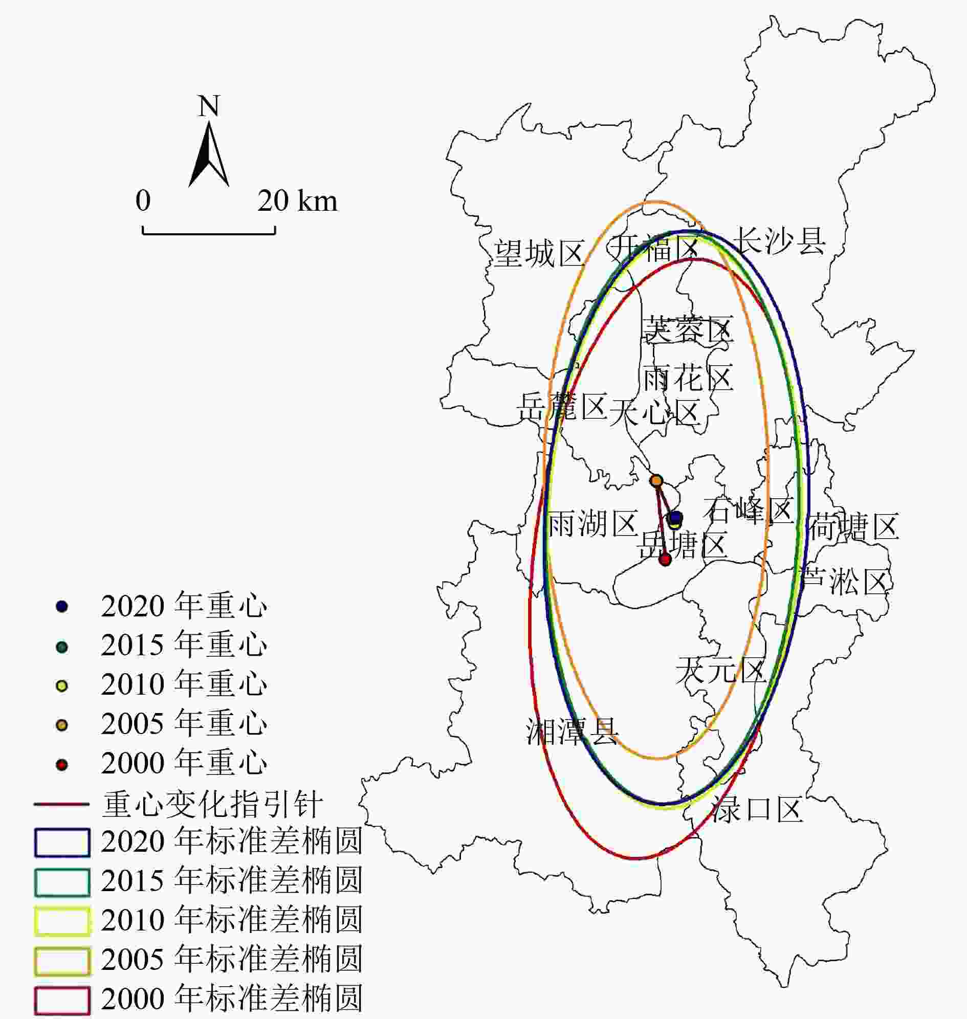
图 2 2000—2020年长株潭都市圈建设用地标准差椭圆
Figure 2. Standard deviation ellipse used for the construction land of Changzhutan metropolitan area from 2000 to 2020

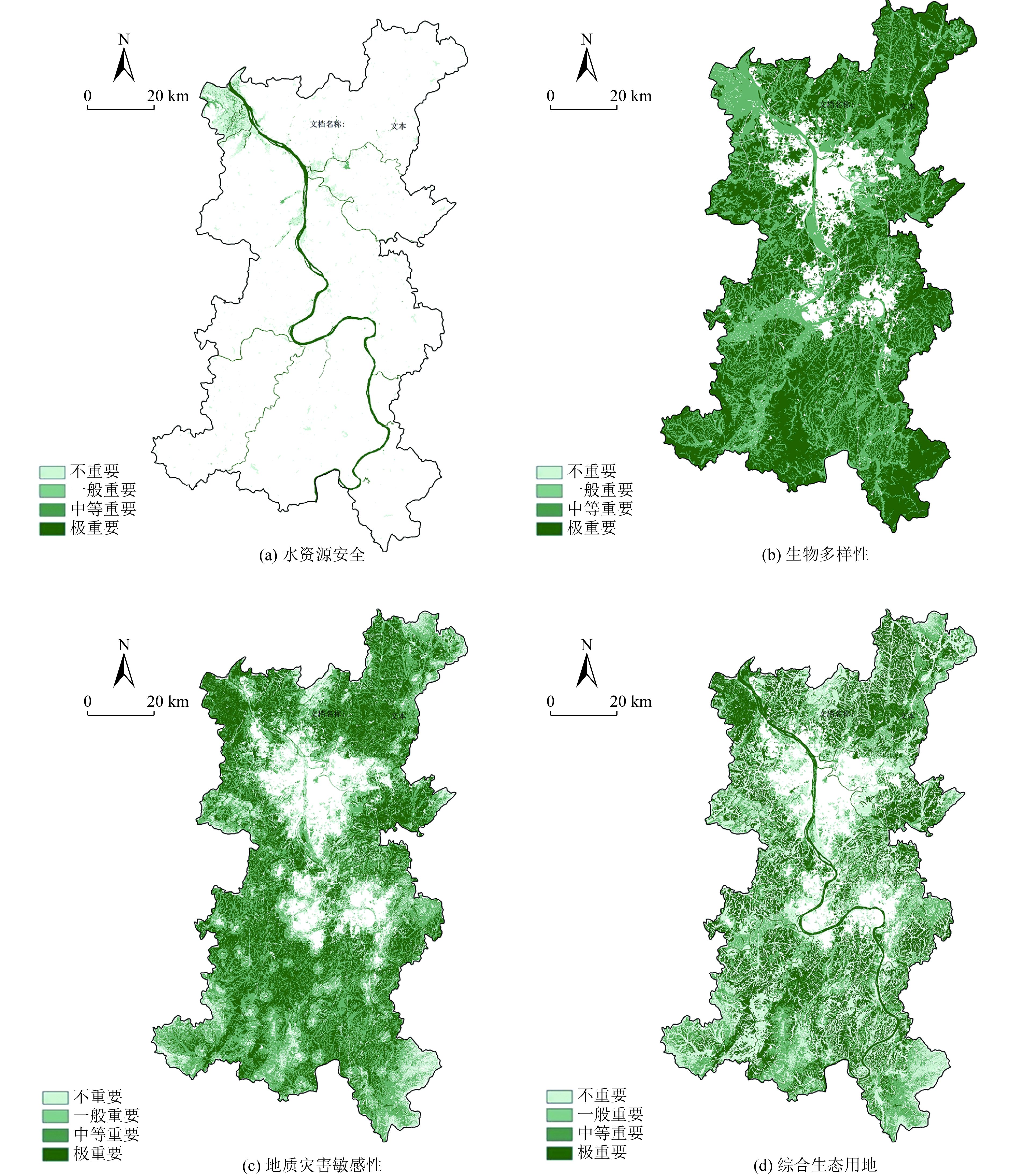
图 3 长株潭都市圈生态因子重要性评价与综合生态用地识别
Figure 3. Evaluation of the importance of ecological factors and identification of comprehensive ecological land in Changzhutan metropolitan area
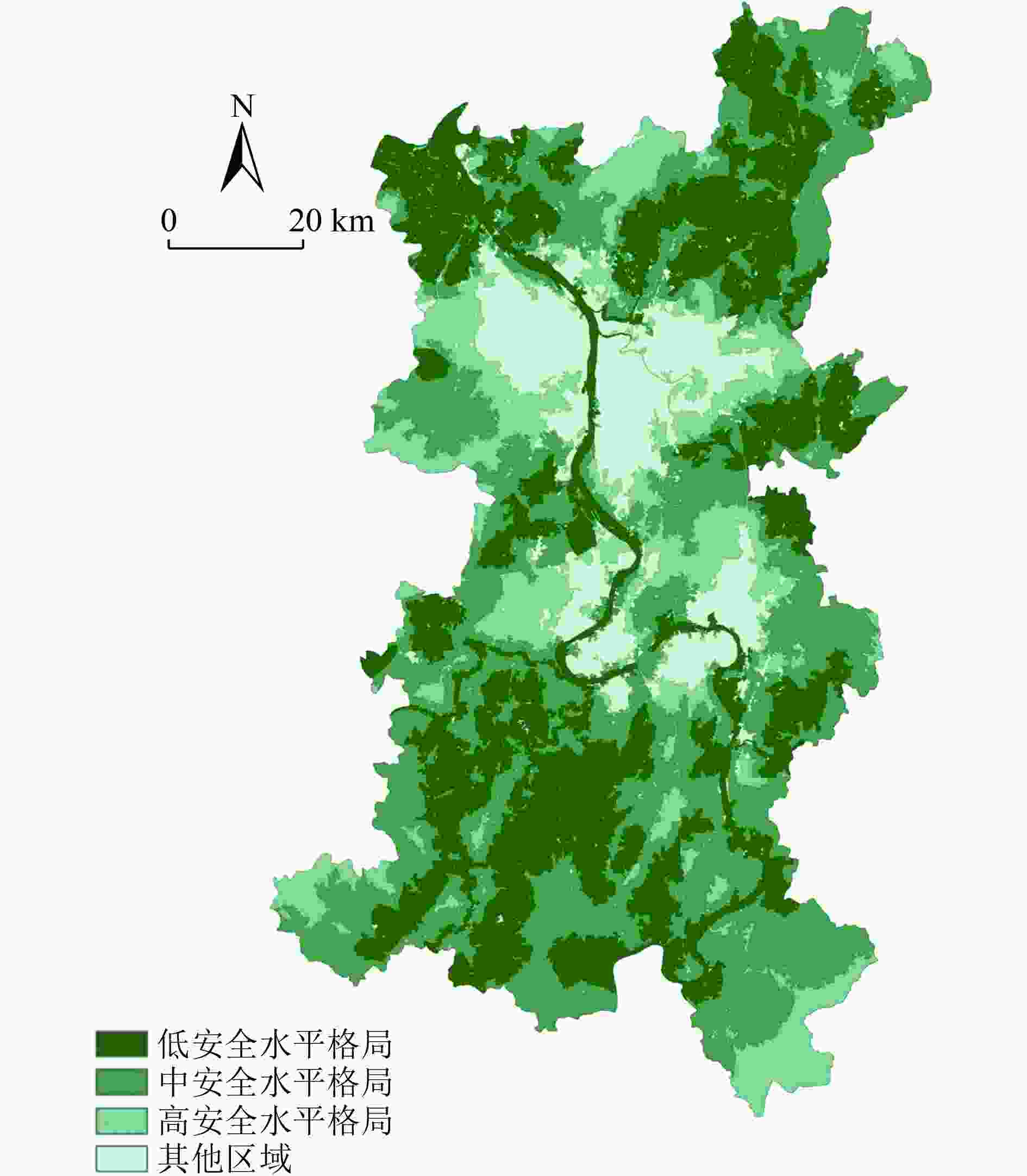
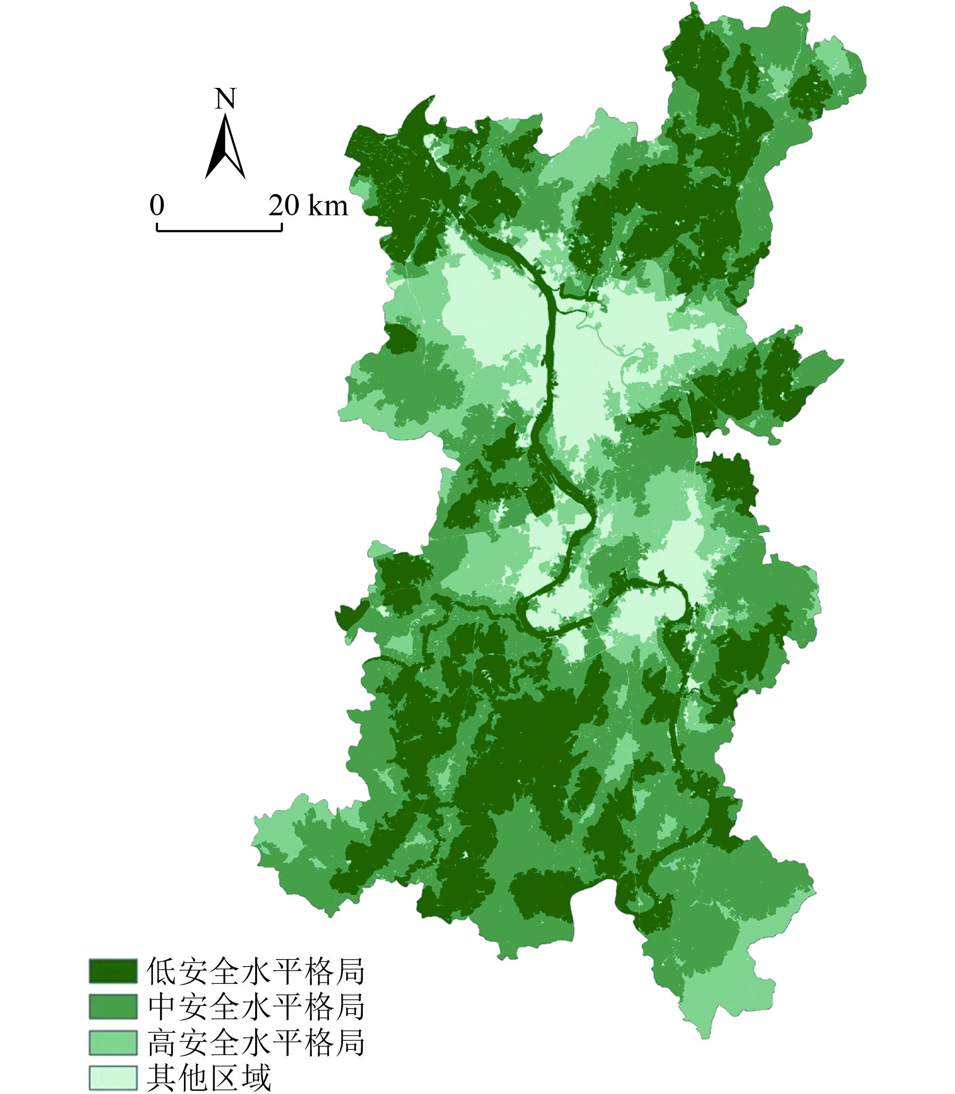
图 4 长株潭都市圈生态安全格局
Figure 4. Ecological security pattern of Changzhutan metropolitan area

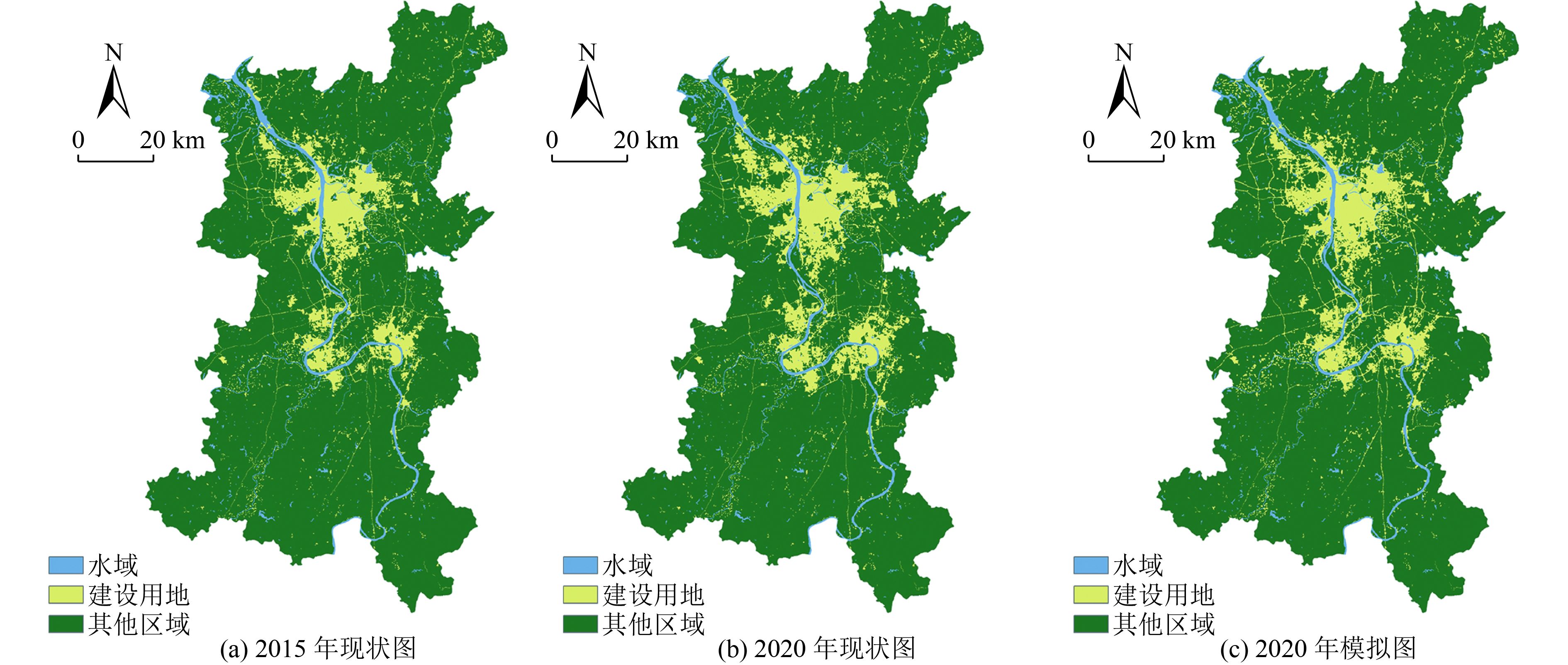
图 5 长株潭都市圈建设用地现状与模拟检验
Figure 5. Status quo and simulation test of construction land in Changzhutan metropolitan area
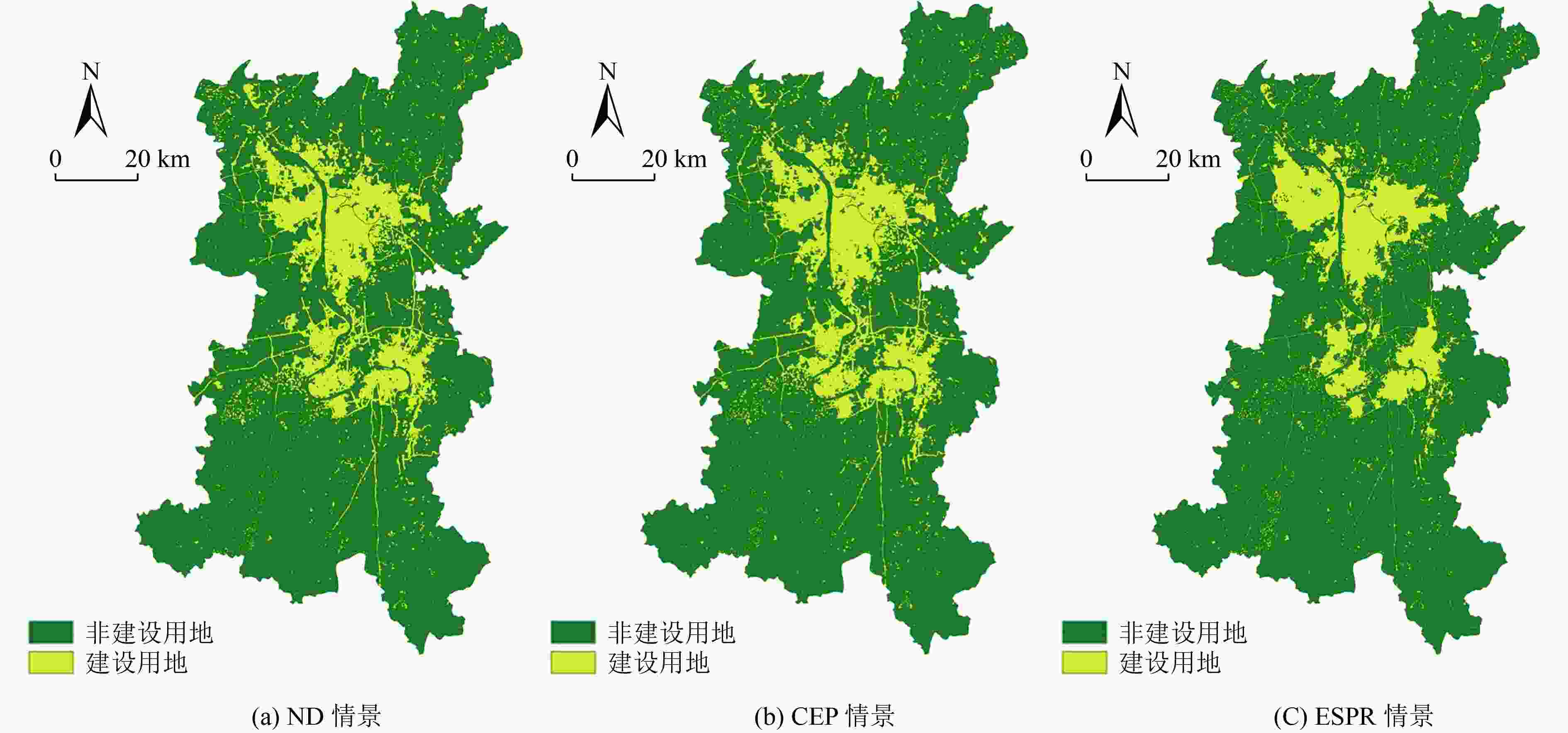
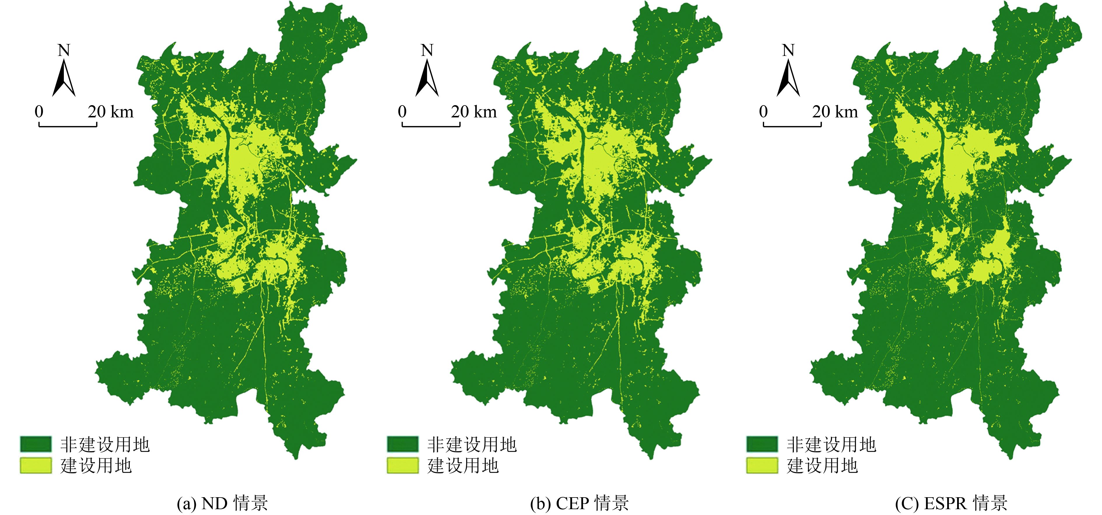
图 6 长株潭都市圈2030年建设用地多情景模拟
Figure 6. Multi-scenario simulation of construction land in Changzhutan metropolitan area in 2030

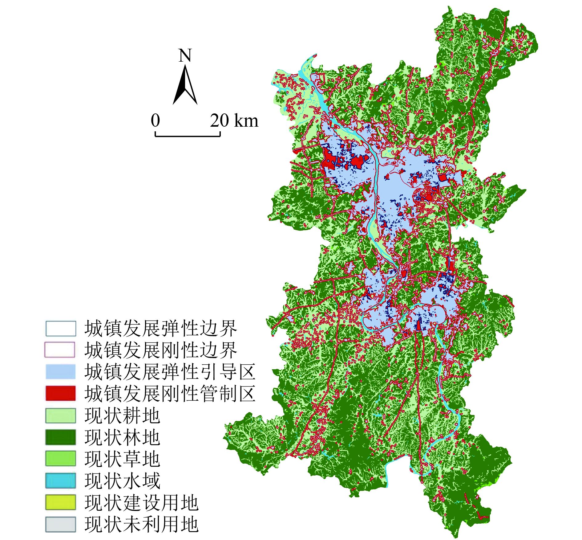
图 7 长株潭都市圈2030年城镇开发边界划定
Figure 7. Delineation of urban development boundary in Changzhutan metropolitan area in 2030
表 1 生物多样性保护功能评价分级标准
Table 1. Classification standards of biodiversity conservation function evaluation
评价因子 分级指标 分值 权重 用地类别 林地、灌木林、疏林地、其他林地 1 0.8 河渠、湖泊、水库坑塘、滩地、沼泽地 2 高覆盖草地、中覆盖草地、低覆盖草地 3 水田、旱地 4 城镇用地、农村居民点、其他建设用地、
裸土地、裸岩石质地5 坡度/(°) 0~2 1 0.2 2~8 2 8~15 3 15~25 4 25~72 5  下载: 导出CSV
表 2 地质灾害的影响因子及其敏感性划分标准
Table 2. The influencing factors of geological disasters and the classification standard of susceptibility
敏感性分值 植被覆盖度/% 高程/m 坡度/(°) 用地分类 1 <30 <25 <2 林地、灌木林、疏林地、其他林地 2 30~45 25~50 2~8 河渠、湖泊、水库坑塘、滩地、沼泽地 3 45~60 50~100 8~15 高覆盖草地、中覆盖草地、低覆盖草地 4 60~75 100~200 15~25 水田、旱地 5 >75 >200 >25 城镇用地、农村居民点、其他建设用地、
裸土地、裸岩石质地权重 0.25 0.2 0.3 0.25
下载: 导出CSV
表 3 长株潭都市圈基本生态阻力系数
Table 3. Basic ecological resistance coefficient of Changzhutan metropolitan area
有林地、河渠、
湖泊水田、灌木林、水库
坑塘、沼泽地疏林地、其他
林地、滩地旱地、高覆盖
度草地中覆盖度草地、
低覆盖度草地裸土地、裸
岩石质地农村居
民点其他建设
用地城镇
用地1 10 20 30 50 200 300 400 500
下载: 导出CSV
表 4 FLUS模型模拟试验相关参数及具体设置情况
Table 4. Relevant parameters and specific settings of FLUS model simulation experiment
模型运行模块 主要参数 说明及要求 具体设置 基于神经网
络的出现概
率计算模块Land Use Data 初始年份用地类型栅格数据,用地类型编号从1开始,属于区域内的用地类型设置为“Valid Data”,
区域外设置为“NoData Value”初始年份为2015年 ANN Training 设置神经网络获取训练样本的采样模式、
采样比例及隐藏层数采样模式为均匀采样模式;采样比例为20,即采样点占研究区有效像元的2%;隐藏层数为12(默认值),层数增高可降低误差,提高概率数据精度 Save Path 设置存放路径及输出概率数据的精度类型 数据精度类型为Single Accuracy Driving Data 加载驱动因子栅格数据,各因子数据的行列数要与用地类型栅格数据保持一致 研究区驱动因子共12个,用于神经网络
适宜性概率计算基于自适应惯性机制的元胞自动机 Land Use Data 初始年份用地类型栅格数据,用地类型编号从1开始,属于区域内的用地类型设置为“Valid Data”,
区域外设置为“NoData Value”初始年份为2015年和2020年 Probability Data 加载适宜性概率数据 基于神经网络的适宜性概率计算模块得到的各用地类型的分布概率数据 Restricted Data 输入约束用地变化的限制数据。该数据为二值数据,即0和1。数值0表示不允许用地类型发生转化,1表示允许发生转化 研究区内的现状河流、核心源地、高安全格局
作为限制区域Simulation Setting 设置模拟参数:Maximum Number of Iteration,300;Neighborhood,3;Accelerate(0-1),0.1;Thread,1 初始年份的用地类型像元数为2015年各用地类型数量;模拟的目标像元数为2020年各用地类型数量;成本转换矩阵根据研究区2015—2020年建设用地面积转移矩阵设置;邻域因子参数为0~1,越接近1表示该用地类型的扩张能力越强,该参数设置情况经多次对比调整后确定 Save Simulation 设置模拟结果保存路径
下载: 导出CSV
表 5 2000—2020年长株潭都市圈建设用地增长速率与强度
Table 5. The growth rate and intensity of construction land in the Changzhutan metropolitan area from 2000 to 2020
时间段 增长速率/% 增长强度 2000—2005年 1 159.4 5.28 2005—2010年 3 921.91 14.13 2010—2015年 446.65 0.94 2015—2020年 183.33 0.37
下载: 导出CSV
-
[1] GRIGORESCU I, KUCSICSA G, POPOVICI E A, et al. Modelling land use/cover change to assess future urban sprawl in Romania[J]. Geocarto International,2021,36(7):721-739. doi: 10.1080/10106049.2019.1624981 [2] 纪荣婷, 陈梅, 刘溪, 等.基于能值生态足迹分析的宁海县可持续发展潜力评价[J]. 环境科学研究,2020,33(12):2752-2760. doi: 10.13198/j.issn.1001-6929.2020.11.05JI R T, CHEN M, LIU X, et al. Sustainable development potential assessment of Ninghai County using an emergy ecological footprint analysis[J]. Research of Environmental Sciences,2020,33(12):2752-2760. doi: 10.13198/j.issn.1001-6929.2020.11.05 [3] 王建军, 周小天.面向国土空间规划的都市圈划定方法研究[J]. 城市问题,2022(1):4-14.WANG J J, ZHOU X T. Research on the methods of metropolitan district delineation for territorial spatial planning[J]. Urban Problems,2022(1):4-14. [4] ZHOU D, LIN Z L, MA S M, et al. Assessing an ecological security network for a rapid urbanization region in Eastern China[J]. Land Degradation & Development,2021,32(8):2642-2660. [5] BORYSIAK J, MIZGAJSKI A, SPEAK A. Floral biodiversity of allotment gardens and its contribution to urban green infrastructure[J]. Urban Ecosystems,2017,20(2):323-335. doi: 10.1007/s11252-016-0595-4 [6] 李皓, 翟月鹏, 杨小龙, 等.基于层次分析-有序加权平均多准则评估的雄安新区生态安全格局模拟研究[J]. 生态学报,2022,42(1):150-160.LI H, ZHAI Y P, YANG X L, et al. Simulating ecological security patterns in the Xiongan New Area based on the multicriteria evaluation of AHP-OWA[J]. Acta Ecologica Sinica,2022,42(1):150-160. [7] 如克亚·热合曼, 阿里木江·卡斯木, 哈力木拉提·阿布来提.基于MSPA和MCR模型的图木舒克市生态安全格局构建[J]. 环境科学与技术,2021,44(5):229-237. doi: 10.19672/j.cnki.1003-6504.2021.05.030REHEMAN R, KASIM A, ABLAT H. Construction of ecological security pattern in tumshuk city based on MSPA and MCR model[J]. Environmental Science & Technology,2021,44(5):229-237. doi: 10.19672/j.cnki.1003-6504.2021.05.030 [8] 李涛, 巩雅博, 戈健宅, 等.基于电路理论的城市景观生态安全格局构建: 以湖南省衡阳市为例[J]. 应用生态学报,2021,32(7):2555-2564.LI T, GONG Y B, GE J Z, et al. Construction of urban landscape ecological security pattern based on circuit theory: a case study of Hengyang City, Hunan Province, China[J]. Chinese Journal of Applied Ecology,2021,32(7):2555-2564. [9] 曹帅, 金晓斌, 杨绪红, 等.耦合MOP与GeoSOS-FLUS模型的县级土地利用结构与布局复合优化[J]. 自然资源学报,2019,34(6):1171-1185. doi: 10.31497/zrzyxb.20190604CAO S, JIN X B, YANG X H, et al. Coupled MOP and GeoSOS-FLUS models research on optimization of land use structure and layout in Jintan District[J]. Journal of Natural Resources,2019,34(6):1171-1185. doi: 10.31497/zrzyxb.20190604 [10] 蔡成瑞, 舒帮荣, 朱慧, 等.顾及区域异质性驱动的土地利用变化模拟模型研究[J]. 中国土地科学,2020,34(11):38-47. doi: 10.11994/zgtdkx.20201109.091252CAI C R, SHU B R, ZHU H, et al. Modeling land use change by considering regional heterogeneous driving mechanism[J]. China Land Science,2020,34(11):38-47. doi: 10.11994/zgtdkx.20201109.091252 [11] 荣月静, 张慧, 王岩松.基于Logistic-CA-Markov与InVEST模型对南京市土地利用与生物多样性功能模拟评价[J]. 水土保持研究,2016,23(3):82-89. doi: 10.13869/j.cnki.rswc.2016.03.015RONG Y J, ZHANG H, WANG Y S. Assessment on land use and biodiversity in Nanjing City based on logistic-CA-Markov and InVEST model[J]. Research of Soil and Water Conservation,2016,23(3):82-89. doi: 10.13869/j.cnki.rswc.2016.03.015 [12] 胡碧松, 张涵玥.基于CA-Markov模型的鄱阳湖区土地利用变化模拟研究[J]. 长江流域资源与环境,2018,27(6):1207-1219. doi: 10.11870/cjlyzyyhj201806004HU B S, ZHANG H Y. Simulation of land-use change in Poyang Lake Region based on CA-Markov model[J]. Resources and Environment in the Yangtze Basin,2018,27(6):1207-1219. doi: 10.11870/cjlyzyyhj201806004 [13] 幸瑞燊, 周启刚.基于Ann-CA-Markov模型的生态空间预测模拟: 以重庆市万州区为例[J]. 生态与农村环境学报,2021,37(6):740-750.XING R S, ZHOU Q G. Predictive simulation of ecological spatial evolution based on ann-CA-Markov model: a case study of Wanzhou District, Chongqing[J]. Journal of Ecology and Rural Environment,2021,37(6):740-750. [14] GEMITZI A. Predicting land cover changes using a CA Markov model under different shared socioeconomic pathways in Greece[J]. GIScience & Remote Sensing,2021,58(3):425-441. [15] 吴永强, 李明凯, 唐中楠, 等.基于灰色动态模型群的衡水市居民年用水量预测[J]. 环境工程技术学报,2022,12(1):267-274. doi: 10.12153/j.issn.1674-991X.20210233WU Y Q, LI M K, TANG Z N, et al. Projection of residential annual water consumption in Hengshui City based on dynamic gray model groups[J]. Journal of Environmental Engineering Technology,2022,12(1):267-274. doi: 10.12153/j.issn.1674-991X.20210233 [16] 宋蕾, 曹银贵, 周伟, 等.基于SD模型的三峡库区快速城镇化地区耕地利用模拟研究[J]. 长江流域资源与环境,2018,27(4):818-827.SONG L, CAO Y G, ZHOU W, et al. Simulation study on cultivated land utilization in rapid urbanization area of Three Gorges Reservoir area based on SD model[J]. Resources and Environment in the Yangtze Basin,2018,27(4):818-827. [17] ZHENG H, YUAN P F. A generative architectural and urban design method through artificial neural networks[J]. Building and Environment,2021,205:108178. doi: 10.1016/j.buildenv.2021.108178 [18] 李媛洁, 叶长盛, 黄小兰.基于CLUE-S模型的南昌市“三生”空间时空演变及情景模拟研究[J]. 水土保持研究,2021,28(5):325-332. doi: 10.13869/j.cnki.rswc.2021.05.037LI Y J, YE C S, HUANG X L. Temporal-spatial evolution and scenario simulation of production-living-ecological space in Nanchang based on CLUE-S model[J]. Research of Soil and Water Conservation,2021,28(5):325-332. doi: 10.13869/j.cnki.rswc.2021.05.037 [19] 杨济达, 欧晓昆, 呙靖雯, 等.基于CA-Markov和Geomod模型橡胶林变化预测比较[J]. 山地学报,2014,32(3):267-276. doi: 10.3969/j.issn.1008-2786.2014.03.002YANG J D, OU X K, GUO J W, et al. Comparison of CA- Markov and geomod models for rubber plantation prediction[J]. Mountain Research,2014,32(3):267-276. doi: 10.3969/j.issn.1008-2786.2014.03.002 [20] 张宸铭, 高尚, 何贝, 等.基于空间句法耦合SLEUTH模型的新老城区扩展模拟研究: 以开封市为例[J]. 地理研究,2021,40(5):1372-1386. doi: 10.11821/dlyj020200431ZHANG C M, GAO S, HE B, et al. Urban expansion simulation around new and old districts based on the loose coupling between space syntax and SLEUTH: a case study of Kaifeng[J]. Geographical Research,2021,40(5):1372-1386. doi: 10.11821/dlyj020200431 [21] 井云清, 张飞, 张月.基于CA-Markov模型的艾比湖湿地自然保护区土地利用/覆被变化及预测[J]. 应用生态学报,2016,27(11):3649-3658. doi: 10.13287/j.1001-9332.201611.027JING Y Q, ZHANG F, ZHANG Y. Change and prediction of the land use/cover in Ebinur Lake Wetland Nature Reserve based on CA-Markov model[J]. Chinese Journal of Applied Ecology,2016,27(11):3649-3658. doi: 10.13287/j.1001-9332.201611.027 [22] PARKER D C, MANSON S M, JANSSEN M A, et al. Multi-agent systems for the simulation of land-use and land-cover change: a review[J]. Annals of the Association of American Geographers,2003,93(2):314-337. doi: 10.1111/1467-8306.9302004 [23] 刘小平, 黎夏, 叶嘉安.基于多智能体系统的空间决策行为及土地利用格局演变的模拟[J]. 中国科学 D辑:地球科学,2006,36(11):1027-1036. [24] MA X N. Simulation of land use spatial layout based on FLUS model: a case study of Huadu District, Guangzhou[J]. Advances in Social Sciences,2019,8(7):1327-1341. doi: 10.12677/ASS.2019.87182 [25] 俞孔坚.生态安全格局与国土空间开发格局优化[J]. 景观设计学,2016,4(5):6-9. [26] 单渌铱, 王海军, 张彬, 等.顾及土地生态安全的环鄱阳湖城市群土地利用情景模拟[J]. 地球信息科学学报,2020,22(3):543-556. doi: 10.12082/dqxxkx.2020.190306SHAN L Y, WANG H J, ZHANG B, et al. Land use simulation of the city clusters around Poyang Lake based on land ecological security assessment[J]. Journal of Geo-Information Science,2020,22(3):543-556. doi: 10.12082/dqxxkx.2020.190306 [27] 王思易, 欧名豪.基于景观安全格局的建设用地管制分区[J]. 生态学报,2013,33(14):4425-4435. doi: 10.5846/stxb201204120515WANG S Y, OU M H. Zoning for regulating of construction land based on landscape security pattern[J]. Acta Ecologica Sinica,2013,33(14):4425-4435. doi: 10.5846/stxb201204120515 [28] 陈阳, 王西平, 甄娜, 等.基于生态系统服务理论内涵的山水林田湖草生态保护修复实践: 以河南省南太行地区试点工程为例[J]. 环境工程技术学报,2021,11(4):701-710. doi: 10.12153/j.issn.1674-991X.20200190CHEN Y, WANG X P, ZHEN N, et al. Practice of ecological protection and restoration of mountain-river-forestfarmland-lake-grassland based on connotation of ecosystem service theory: taking the pilot project of South-Taihang Area in Henan Province as an example[J]. Journal of Environmental Engineering Technology,2021,11(4):701-710. doi: 10.12153/j.issn.1674-991X.20200190 [29] 童亮, 姚晓洁, 王霞.基于电路理论的农耕平原地区生态安全格局构建: 以亳州市为例[J]. 环境科学与技术,2020,43(11):217-226.TONG L, YAO X J, WANG X. Construction of ecological security pattern in agricultural Plains based on circuit theory: a case study of Bozhou City[J]. Environmental Science & Technology,2020,43(11):217-226. [30] 邓淏丹, 叶露锋, 刘丽香, 等.城市生态安全研究进展[J]. 环境工程技术学报,2022,12(1):248-259. doi: 10.12153/j.issn.1674-991X.20210179DENG H D, YE L F, LIU L X, et al. Review of urban ecological security research[J]. Journal of Environmental Engineering Technology,2022,12(1):248-259. doi: 10.12153/j.issn.1674-991X.20210179 [31] 刘骏,唐芝玉.基于文本解读的重庆城市绿地系统规划变迁与发展研究[J]. 中国园林,2022,38(8):99-104.Liu Jun, Tang Zhiyu. Research on the Change and Development of Chongqing Urban Green Space System Planning Based on Text Interpretation[J]. Chinese Landscape Architecture,2022,38(8):99-104. [32] 刘延国, 李景吉, 逯亚峰, 等.西南山区生态保护红线划定方法优化: 基于生态地质环境脆弱性评估[J]. 生态学报,2021,41(14):5825-5836.LIU Y G, LI J J, LU Y F, et al. Optimization method of ecological redline delineation in Southwest China from the view of eco-geo environment vulnerability assessment[J]. Acta Ecologica Sinica,2021,41(14):5825-5836. [33] 吕红亮, 周霞, 党冰, 等.基于生态过程的城市生态基础设施空间实现: 以南京江北新区为例[J]. 城市发展研究,2020,27(6):19-26.LÜ H L, ZHOU X, DANG B, et al. Realization of urban ecological infrastructure space based on ecological process[J]. Urban Development Studies,2020,27(6):19-26. [34] 任保平, 杜宇翔.黄河流域经济增长-产业发展-生态环境的耦合协同关系[J]. 中国人口·资源与环境,2021,31(2):119-129.REN B P, DU Y X. Coupling coordination of economic growth, industrial development and ecology in the Yellow River Basin[J]. China Population, Resources and Environment,2021,31(2):119-129. [35] 陈炳, 曾刚, 曹贤忠, 等.长三角城市群生态文明建设与城市化耦合协调发展研究[J]. 长江流域资源与环境,2019,28(3):530-541.CHEN B, ZENG G, CAO X Z, et al. Coupling coordination development between ecological civilization construction and urbanization in Yangtze River Delta Urban Agglomerations[J]. Resources and Environment in the Yangtze Basin,2019,28(3):530-541. ⊕ -

 下载:
下载:


 点击查看大图
计量
- 文章访问数: 240
- HTML全文浏览量: 146
- PDF下载量: 21
- 被引次数: 0