

Research on the dynamic changes of ecological environment quality based on the project of converting cropland to forest: taking Lanping County in Yunnan Province as an example
-
摘要:
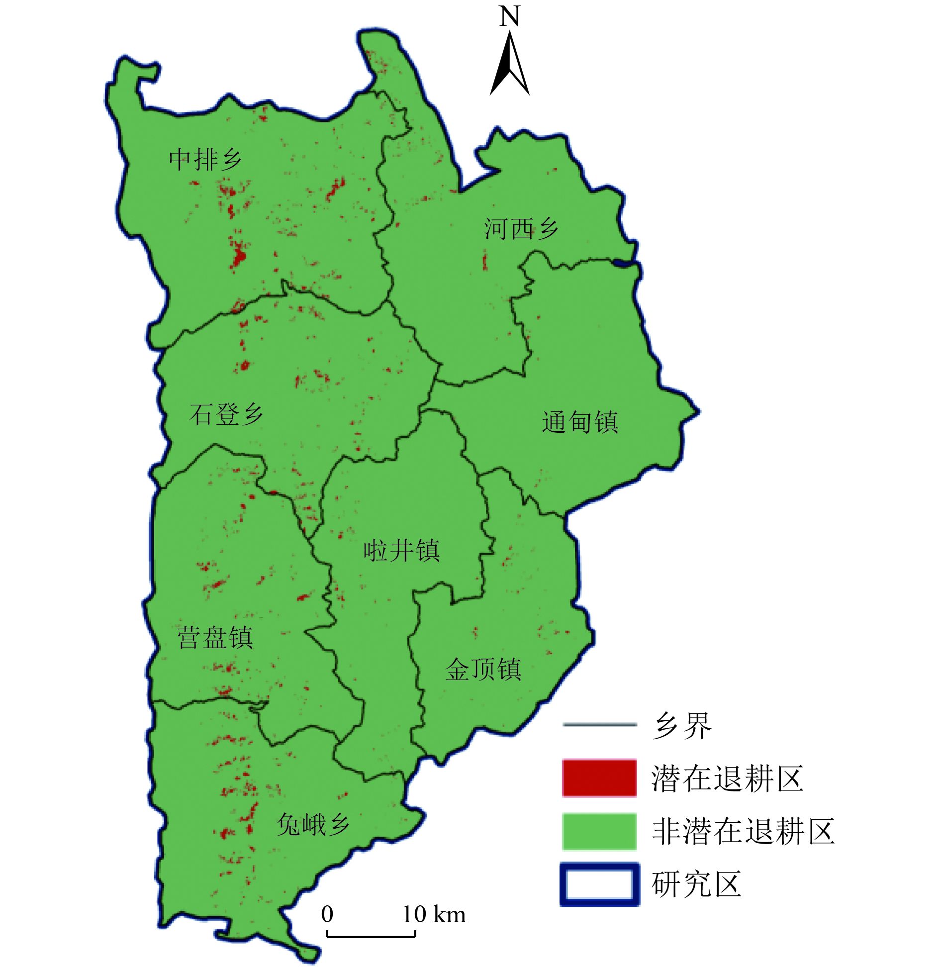
2014年云南省怒江傈僳族自治州(简称怒江州)正式启动新一轮退耕还林还草工程,为探讨该轮退耕还林工程对怒江州兰坪白族普米族自治县(简称兰坪县)生态环境质量的影响,选择退耕还林工程实施前(2013年)、实施中(2017年)和实施末期(2020年)3个时间,基于遥感生态指数模型,选取绿度、干度、湿度和热度4个指标,运用主成分分析法对兰坪县2013—2020年的生态环境质量动态变化进行研究。结果表明:1)2013—2020年兰坪县生态环境质量处于上升趋势,中排乡、石登乡和河西乡的生态环境质量改善较为明显;2)2013—2020年,75%以上区域的生态环境质量等级保持不变,其他区域的生态环境质量等级呈小幅度变化,生态环境质量变好的区域面积要大于生态环境质量变差的区域面积;3)退耕还林斑块的生态环境质量提升程度要高于退耕还林2 km缓冲区以及整个研究区的生态环境质量提高程度,退耕还林工程对生态环境质量的改善具有显著影响,可通过进一步推进退耕还林工程来改善兰坪县的生态环境质量;4)研究区潜在的退耕区主要分布在中排乡、石登乡、营盘镇和兔峨乡4个乡镇,其可作为进一步退耕还林的重点区域。
-
关键词:
- 生态环境质量 /
- 退耕还林工程 /
- 遥感生态指数(RSEI)模型 /
- 主成分分析 /
- 动态变化
Abstract:In 2014, Nujiang Lisu Autonomous Prefecture (Nujiang Prefecture for short) in Yunnan Province officially launched a new round of converting cropland to forest project. In order to explore the impact of the round of conversion of cropland to forest project on the quality of the ecological environment in Lanping Bai Pumi Autonomous County (Lanping County for short) in Nujiang Prefecture, three periods of time were selected: before the implementation of the project (2013), during the implementation of the project (2017), and at the end of the project (2020). Based on remote sensing ecological index (RSEI) model, four indexes, including greenness, dryness, wetness and heat, were selected and principal component analysis method adopted to study the dynamic changes of the ecological environment quality in Lanping County from 2013 to 2020. The results showed that: 1) The ecological environment quality of Lanping County had been on the rise from 2013 to 2020, and the ecological environment quality of Zhongpai Township, Shideng Township and Hexi Township improved significantly. 2) From 2013 to 2020, the ecological environment quality level of more than 75% of the regions had remained unchanged, and the ecological environment quality levels of other regions changed slightly. The area of better ecological environment was larger than the area of worse ecological environment. 3) The improvement degree of the ecological environment quality of the converting cropland to forest patches was higher than that of 2 km buffer zone of the converting cropland to forest project and the whole study area. The conversion of cropland to forest project had a significant impact on the improvement of the ecological environment quality. The ecological environment of Lanping County could be improved by further promoting the project of converting cropland to forest. 4) The potential abandoned farmlands in the study area were mainly distributed in the four townships of Zhongpai Township, Shideng Township, Yingpan Township and Tu'e Township, which could be used as key areas for further conversion of farmland to forests.armland to forests.
-
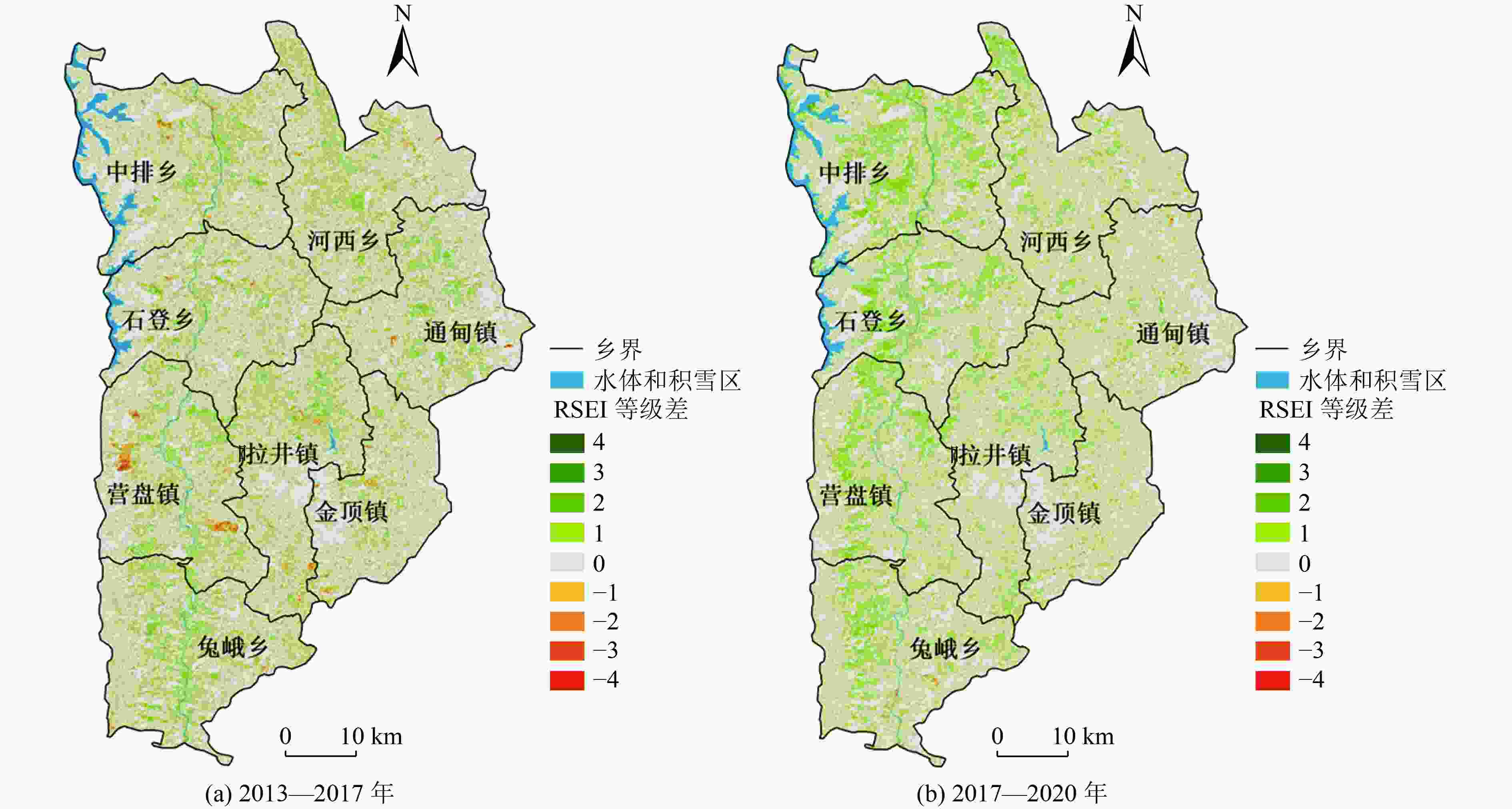
图 3 兰坪县2013—2017年、2017—2020年RSEI等级变化
Figure 3. RSEI grade changes in Lanping County from 2013 to 2017 and from 2017 to 2020
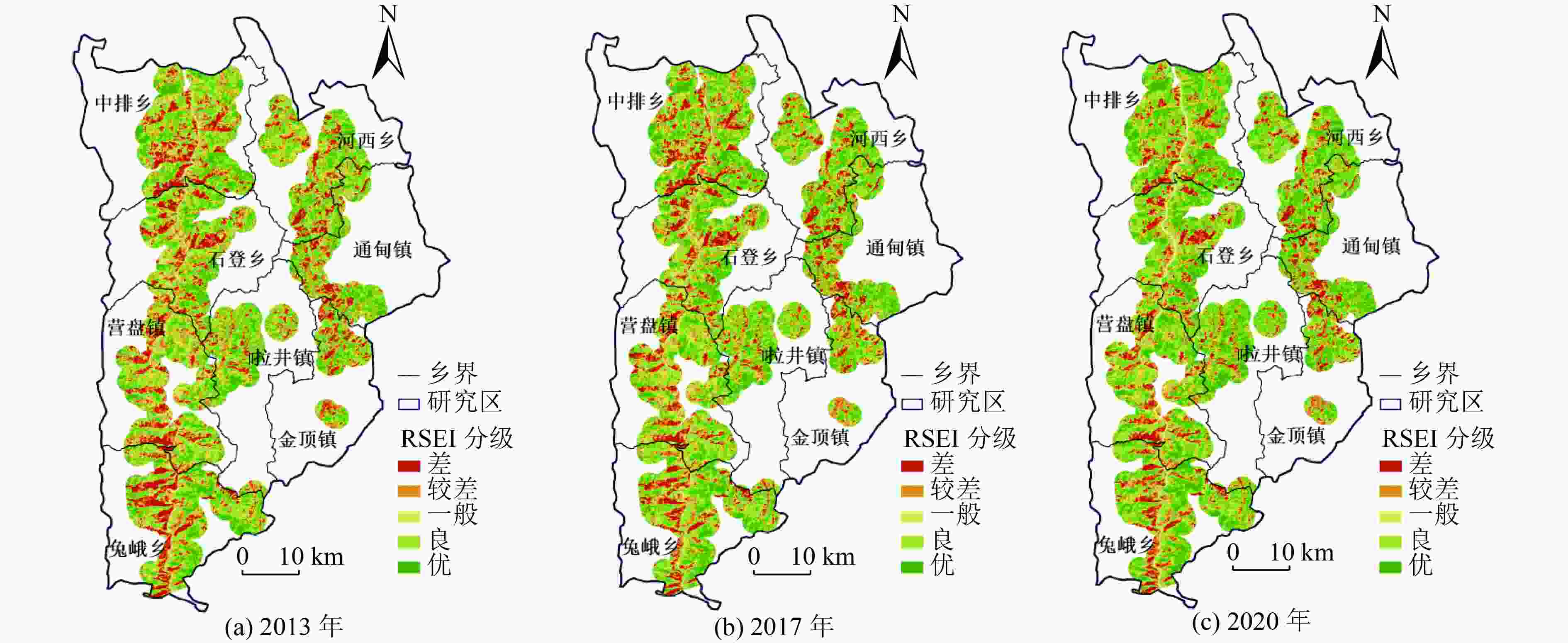
图 4 兰坪县2013—2020年退耕还林区RSEI分级
Figure 4. RSEI grading diagram of converting cropland to forests in Lanping County in 2013-2020
表 1 主成分贡献率及特征值
Table 1. Principal component contribution rate and characteristic value
年份 PC1 PC2 PC3 PC4 特征值 累计贡献率/% 特征值 累计贡献率/% 特征值 累计贡献率/% 特征值 累计贡献率/% 2013 0.437392 93.01 0.020 707 97.41 0.008 307 99.18 0.003 860 100 2017 0.453 598 92.78 0.022 273 97.33 0.008 360 99.04 0.004 676 100 2020 0.466 896 93.24 0.020 592 97.35 0.008 849 99.11 0.004 434 100  下载: 导出CSV
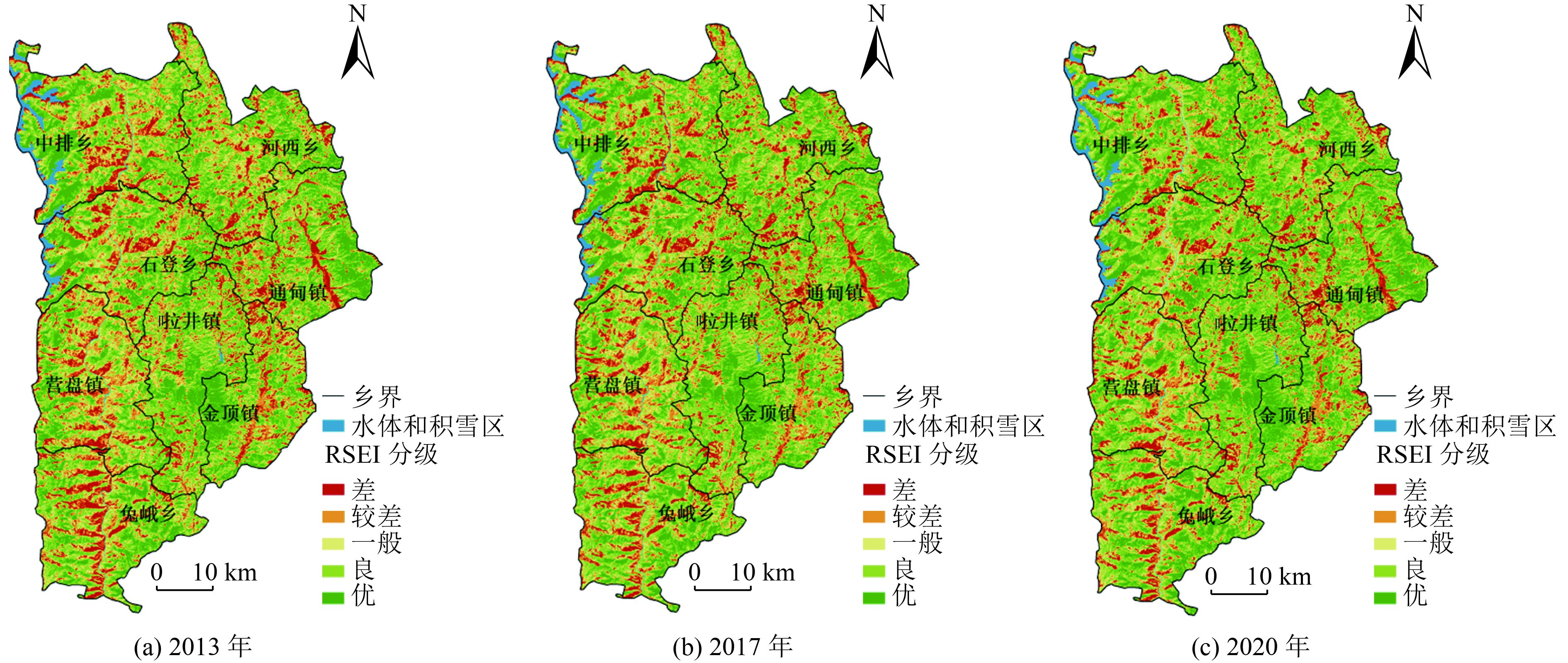
表 2 兰坪县2013—2020年RSEI各等级面积及占比
Table 2. Area and proportion of RSEI grades in Lanping County from 2013 to 2020
RSEI等级 2013年 2017年 2020年 面积/km2 占比/% 面积/km2 占比/% 面积/km2 占比/% 差 482.693 4 11.24 461.662 2 10.75 404.1216 9.41 较差 656.123 4 15.27 613.689 3 14.28 529.354 8 12.32 一般 859.662 9 20.01 816.264 0 19.00 763.396 2 17.77 良 1 133.527 5 26.38 1 175.706 0 27.37 1 238.389 2 28.82 优 1 164.295 8 27.10 1 228.981 5 28.61 1 361.041 2 31.68 合计 4 296.303 0 100 4 296.303 0 100 4 296.303 0 100
下载: 导出CSV
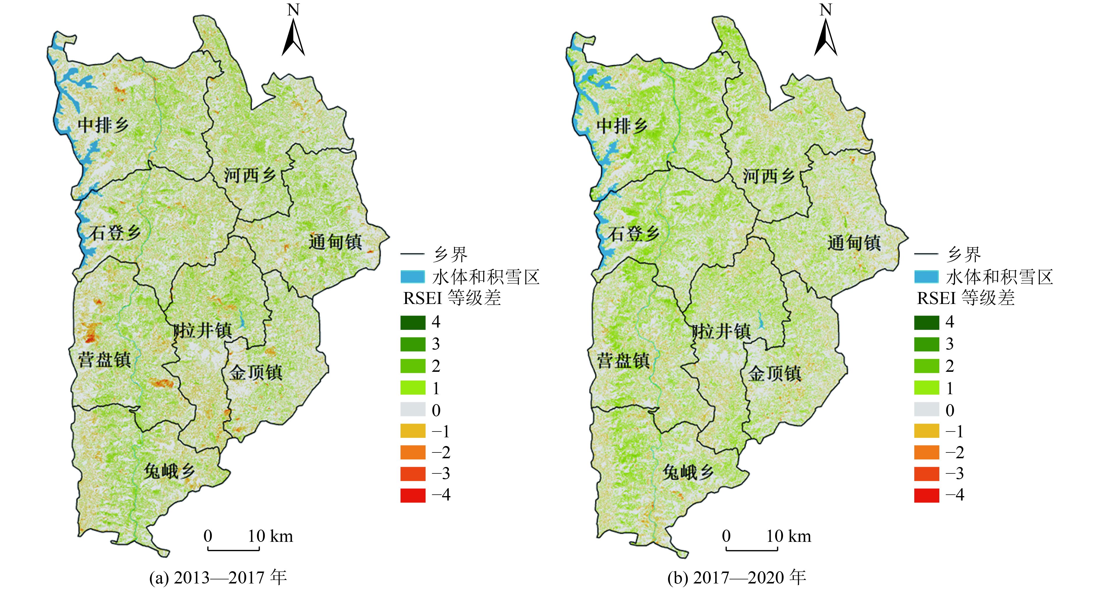
表 3 兰坪县RSEI等级变化统计结果
Table 3. Statistical table of RSEI grade changes in Lanping County
类别 等级差 2013—2017年 2017—2020年 等级面积
/km2等级面积占比/% 类别面积/km2 类别面积占比/% 等级面积/km2 等级面积占比/% 类别面积/km2 类别面积占比/% 等级变差 −4 0.515 7 0.01 372.660 3 8.67 0.076 5 0.00 276.760 8 6.44 −3 3.719 7 0.09 0.653 4 0.02 −2 18.302 4 0.43 4.744 8 0.11 −1 350.122 5 8.15 271.286 1 6.31 等级不变 0 3 277.863 9 76.29 3 277.863 9 76.29 3 232.883 7 75.25 3 232.883 7 75.25 等级变好 1 635.800 5 14.80 645.778 8 15.03 765.178 2 17.81 786.658 5 18.31 2 9.740 7 0.23 20.376 9 0.47 3 0.236 7 0.01 1.085 4 0.03 4 0.000 9 0.00 0.018 0 0.00 注:−1为RSEI等级降低一级,1为RSEI等级升高一级,其他等级差含义以此类推。
下载: 导出CSV
表 4 研究区、退耕还林2 km缓冲区以及退耕还林斑块内的RSEI平均值
Table 4. RSEI mean values in the study area, 2 km buffer zone and patches of converting cropland to forests
区域 2013年 2017年 2020年 2013—2017年增加值 2017—2020年增加值 2013—2020年增加值 研究区 0.587 220 0.598 471 0.623 225 0.011 251 0.024 754 0.036 005 退耕还林2 km缓冲区 0.540 166 0.561 128 0.595 963 0.020 962 0.034 835 0.055 797 退耕还林斑块 0.357 117 0.384 573 0.437 176 0.027 456 0.052 603 0.080 059
下载: 导出CSV
表 5 兰坪县退耕还林区2013—2017年RSEI等级转移矩阵
Table 5. RSEI grade transfer matrix of converting cropland to forests in Lanping County in 2013-2017
等级 2013年 差 较差 一般 良 优 合计 2017年 差 212.949 9 33.898 5 2.848 5 1.031 4 0.184 5 250.912 8 较差 54.099 9 259.869 6 41.040 0 3.398 4 0.512 1 358.920 0 一般 2.346 3 95.743 8 302.515 2 38.657 7 2.067 3 441.330 3 良 0.134 1 2.922 3 125.803 8 370.060 2 38.547 9 537.468 3 优 0 0.021 6 1.003 5 101.430 0 376.766 1 479.221 2 合计 269.530 2 392.455 8 473.211 0 514.577 7 418.077 9 2 067.852 6
下载: 导出CSV
表 6 兰坪县退耕还林区2017—2020年RSEI等级转移矩阵
Table 6. RSEI grade transfer matrix of converting cropland to forests in Lanping County in 2017-2020
等级 2017年 差 较差 一般 良 优 合计 2020年 差 185.897 7 27.079 2 0.947 7 0.134 1 0.042 3 214.101 0 较差 59.555 7 217.307 7 28.538 1 0.929 7 0.161 1 306.492 3 一般 5.368 5 109.087 2 263.831 4 29.774 7 0.639 0 408.700 8 良 0.090 0 5.423 4 146.745 9 378.216 9 29.551 5 560.027 7 优 0.000 9 0.022 5 1.267 2 128.412 9 448.827 3 578.530 8 合计 250.912 8 358.920 0 441.330 3 537.468 3 479.221 2 2 067.852 6
下载: 导出CSV
-
[1] 王志杰, 代磊.黔中喀斯特山地城市土地利用/覆被变化及其生态效应评价: 以贵阳市花溪区为例[J]. 生态学报,2021,41(9):3429-3440.WANG Z J, DAI L. Assessment of land use/cover changes and its ecological effect in karst mountainous cities in central Guizhou Province: taking Huaxi District of Guiyang City as a case[J]. Acta Ecologica Sinica,2021,41(9):3429-3440. [2] 纪荣婷, 陈梅, 程虎, 等.国家“两山”基地经济与生态环境协调发展评价: 以浙江省宁海县为例[J]. 环境工程技术学报,2020,10(5):798-805. doi: 10.12153/j.issn.1674-991X.20190211JI R T, CHEN M, CHENG H, et al. Assessment of economic and environmental coordination development degree in the “Two Mountains” Base: a case study of Ninghai County in Zhejiang Province[J]. Journal of Environmental Engineering Technology,2020,10(5):798-805. doi: 10.12153/j.issn.1674-991X.20190211 [3] 中国林业网. 退耕还林工程简报第2期(总第205期)[EB/OL]. (2018-06-21)[2021-09-20]. https://www.forestry.gov.cn/main/436/20180621/111014393206540.html. [4] 中国林业网. 退耕还林工程简报第10期(总第216期)[EB/OL]. (2020-08-03)[2021-09-20]. http://www.forestry.gov.cn/main/436/20200803/154443265582420.html. [5] 罗海波, 钱晓刚, 刘方, 等.喀斯特山区退耕还林(草)保持水土生态效益研究[J]. 水土保持学报,2003,17(4):31-34. doi: 10.3321/j.issn:1009-2242.2003.04.008LUO H B, QIAN X G, LIU F, et al. Ecological benefit of soil and water conservation in hilly areas by de farming and reafforestation[J]. Journal of Soil Water Conservation,2003,17(4):31-34. doi: 10.3321/j.issn:1009-2242.2003.04.008 [6] 李蕾, 刘黎明, 谢花林.退耕还林还草工程的土壤保持效益及其生态经济价值评估: 以固原市原州区为例[J]. 水土保持学报,2004,18(1):161-163. doi: 10.3321/j.issn:1009-2242.2004.01.043LI L, LIU L M, XIE H L. Eco-economic benefit evaluation of soil conservation service of cropland conversion program: a case study of Yuanzhou district in Guyuan City[J]. Journal of Soil Water Conservation,2004,18(1):161-163. doi: 10.3321/j.issn:1009-2242.2004.01.043 [7] 高国雄, 李文忠, 周心澄, 等.青海大通县退耕还林不同配置模式生态服务功能的评价[J]. 西北农林科技大学学报(自然科学版),2007,35(3):129-134.GAO G X, LI W Z, ZHOU X C, et al. Synthetic assessment on ecology service function of conversion cropland to forest in Datong County of Qinghai Province[J]. Journal of Northwest A & F University (Natural Science Edition),2007,35(3):129-134. [8] 李莉, 张华.基于退耕还林还草背景的奈曼旗生态环境质量评价[J]. 国土与自然资源研究,2010(1):48-49. doi: 10.3969/j.issn.1003-7853.2010.01.023LI L, ZHANG H. The evaluation on eco-environmental quality based on brain for breen in Naiman Qi[J]. Territory & Natural Resources Study,2010(1):48-49. doi: 10.3969/j.issn.1003-7853.2010.01.023 [9] 高凤杰, 侯大伟, 马泉来, 等.退耕还林背景下寒地山区土地生态安全演变研究[J]. 干旱区地理,2016,39(4):800-808.GAO F J, HOU D W, MA Q L, et al. Land use and ecological security in cold mountain area under background of sloping land conversion program[J]. Arid Land Geography,2016,39(4):800-808. [10] 王静, 姚顺波, 刘天军.退耕还林(草)工程实施以来降水利用效率演变格局及归因: 以宝鸡地区为例[J]. 干旱区研究,2020,37(5):1233-1245.WANG J, YAO S B, LIU T J. The evolution pattern and attribution of rainfall use efficiency since the implementation of the project of returning farmland to forest (grass): a case study in Baoji[J]. Arid Zone Research,2020,37(5):1233-1245. [11] CRABTREE B, BAYFIELD N. Developing sustainability indicators for mountain ecosystems: a study of the Cairngorms, Scotland[J]. Journal of Environmental Management,1998,52(1):1-14. [12] CHENG Y, LI L. Study on the ecological environment impact assessment of the port engineering based on the PSR model[J]. Applied Mechanics and Materials,2013,361/362/363:917-920. [13] 张型芳, 王文静, 罗宏, 等.城市土地资源中生态环境承载力指标体系的构建及应用: 以北京市为例[J]. 环境工程技术学报,2017,7(2):209-215. doi: 10.3969/j.issn.1674-991X.2017.02.031ZHANG X F, WANG W J, LUO H, et al. Construction and application of index system of ecological environment carrying capacity of urban land resources: a case study of Beijing[J]. Journal of Environmental Engineering Technology,2017,7(2):209-215. doi: 10.3969/j.issn.1674-991X.2017.02.031 [14] LIU Y B, DU W Y, CHEN N C, et al. Construction and evaluation of the integrated perception ecological environment indicator (IPEEI) based on the DPSIR framework for smart sustainable cities[J]. Sustainability,2020,12(17):7112. doi: 10.3390/su12177112 [15] 王宏伟, 张小雷, 乔木, 等.基于GIS的伊犁河流域生态环境质量评价与动态分析[J]. 干旱区地理,2008,31(2):215-221.WANG H W, ZHANG X L, QIAO M, et al. Assessment and dynamic analysis of the eco-environmental quality in the Ili River Basin based on GIS[J]. Arid Land Geography,2008,31(2):215-221. [16] MUXIKA I, BORJA Á, BALD J. Using historical data, expert judgement and multivariate analysis in assessing reference conditions and benthic ecological status, according to the European Water Framework Directive[J]. Marine Pollution Bulletin,2007,55(1/2/3/4/5/6):16-29. [17] 阿依努尔·玉山江. 中亚五国及中国新疆生态系统健康动态评价研究[D]. 乌鲁木齐: 新疆大学, 2019. [18] 王鹏, 魏信, 乔玉良.多尺度下汾河流域生态环境质量评价与时序分析[J]. 遥感技术与应用,2011,26(6):798-807. doi: 10.11873/j.issn.1004-0323.2011.6.798WANG P, WEI X, QIAO Y L. Quality evaluation and time sequential analysis of eco-environment at multi-scales in Fen River Basin[J]. Remote Sensing Technology and Application,2011,26(6):798-807. doi: 10.11873/j.issn.1004-0323.2011.6.798 [19] SHAN W, JIN X B, REN J, et al. Ecological environment quality assessment based on remote sensing data for land consolidation[J]. Journal of Cleaner Production,2019,239:118126. doi: 10.1016/j.jclepro.2019.118126 [20] 张旺雄. 基于RSEI和RSEDI的柴达木盆地生态环境质量评价及成因分析[D]. 兰州: 西北师范大学, 2020. [21] 杨凤海, 宋佳佳, 赵烨荣, 等.东北黑土水土流失区生态环境遥感动态监测[J]. 环境科学研究,2018,31(9):1580-1587.YANG F H, SONG J J, ZHAO Y R, et al. Dynamic monitoring of ecological environment in black soil erosion area of northeast China based on remote sensing[J]. Research of Environmental Sciences,2018,31(9):1580-1587. [22] SONG H M, XUE L. Dynamic monitoring and analysis of ecological environment in Weinan City, Northwest China based on RSEI model[J]. Ying Yong Sheng Tai Xue Bao = the Journal of Applied Ecology,2016,27(12):3913-3919. [23] 徐涵秋.区域生态环境变化的遥感评价指数[J]. 中国环境科学,2013,33(5):889-897. doi: 10.3969/j.issn.1000-6923.2013.05.019XU H Q. A remote sensing index for assessment of regional ecological changes[J]. China Environmental Science,2013,33(5):889-897. doi: 10.3969/j.issn.1000-6923.2013.05.019 [24] 林玉英, 胡喜生, 邱荣祖, 等.基于Landsat影像的NDVI对植被与影响因子交互耦合的响应[J]. 农业机械学报,2018,49(10):212-219. doi: 10.6041/j.issn.1000-1298.2018.10.024LIN Y Y, HU X S, QIU R Z, et al. Responses of landsat-based NDVI to interaction of vegetation and influencing factors[J]. Transactions of the Chinese Society for Agricultural Machinery,2018,49(10):212-219. doi: 10.6041/j.issn.1000-1298.2018.10.024 [25] 王小磊. 基于遥感生态指数的阜新市生态环境质量研究[D]. 阜新: 辽宁工程技术大学, 2019. [26] 吴映曈, 刘春晖, 赵婷婷.习近平生态文明视阈下基于RSEI技术的伊敏矿区生态环境质量研究[J]. 北方园艺,2020(13):91-98. doi: 10.11937/bfyy.20200316WU Y T, LIU C H, ZHAO T T. Research on ecological environment quality of Yimin mining area based on RSEI technology from the perspective of Xi Jinping's Thought of Ecological Civilization[J]. Northern Horticulture,2020(13):91-98. doi: 10.11937/bfyy.20200316 [27] 刘总堂, 李春海, 章钢娅.运用主成分分析法研究云南湖库水体中重金属分布[J]. 环境科学研究,2010,23(4):459-466.LIU Z T, LI C H, ZHANG G Y. Application of principal component analysis to the distributions of heavy metals in the water of lakes and reservoirs in Yunnan Province[J]. Research of Environmental Sciences,2010,23(4):459-466. [28] 李益敏, 王东驰, 袁静, 等.退耕还林背景下泸水市生态环境质量遥感动态变化[J]. 水土保持研究,2021,28(4):266-274.LI Y M, WANG D C, YUAN J, et al. Remote sensing evaluation of ecological environment quality in Lushui City under the influence of the conversion of cropland to forest project[J]. Research of Soil and Water Conservation,2021,28(4):266-274. [29] 张燕. 我国基本农田保护制度研究[D]. 杨凌: 西北农林科技大学, 2013. -

 下载:
下载:


 点击查看大图

计量
- 文章访问数: 211
- HTML全文浏览量: 121
- PDF下载量: 16
- 被引次数: 0