

Software development and application of key source areas identification of agricultural non-point source pollution based on multi-scenario analysis
-
摘要:
为解决农业面源污染关键源区识别过程中情景单一、数据量大、涉及环节多,以及模型复杂、操作繁琐和治理效果不明确等问题,采用GIS技术结合InVEST的产水量与营养物传输率模型,构建可进行农业面污染关键源区识别与治理模拟的信息系统。设计了基于入河负荷、潜在径流浓度、负荷与产水量比值3种不同情景下的关键源区识别功能,模拟了3种情景下关键源区的分布状况;整合了InVEST的产水量、营养物传输率和流失负荷等模型;设计了面源污染关键源区治理模拟功能,可直观展示3种情景下识别出的关键源区的治理效果;并以海河流域为例,应用该软件对农田总氮(TN)面源关键源区进行了识别和模拟治理。结果表明:1)基于入河负荷情景下识别出的关键源区较为分散,分布在除永定河与子牙河水系外的大部分水系;基于潜在径流浓度情景下的关键源区分布较为集中,多分布在流域中部至南部,其余分布在东南部;基于负荷与产水量比值情景下识别出的关键源区分布高度集中,分布在流域中部至南部。2)基于潜在径流浓度、负荷与产水量比值情景在TN、总磷(TP)模拟治理中的效果接近,且明显优于基于入河负荷情景;结合软件中设定的基于入河负荷、潜在径流浓度、负荷与产水量比值3种情景进行分析,能降低复杂地理环境带来的影响,提高面源污染关键源区的识别效率,提升面源污染关键源区治理决策的科学性,具有实用性。
Abstract:There exists the problems of single scenario, large amount of data, multiple links involved, complex models, cumbersome operations and unclear governance effects in the process of identifying the key source areas of agricultural non-point source pollution (ANSP). To solve these problems, an information system that could identify and simulate the treatment of the key source areas of ANSP was constructed by using GIS technology combined with InVEST water yield and nutrient transfer rate model. The key source areas identification function was designed under three scenarios, based on the river inflow load, potential runoff concentration and load to water yield ratio, respectively, and the distribution of key source areas under the three scenarios was simulated. The water yield, nutrient transfer rate and loss load sub-models of InVEST were integrated. A simulation function for the treatment of key source areas of ANSP was designed, which could visually display the treatment effects of the key source areas identified under the three scenarios. Taking Haihe River Basin as an example, the software was used to identify and simulate the treatment of the key source areas of non-point source of total nitrogen (TN) in farmland. The results showed that: 1) The key source areas identified based on the river inflow load scenario were relatively scattered, and distributed in most of the water systems except Yongding River and Ziya River. Based on the potential runoff concentration scenario, the distribution of key source areas was relatively concentrated, mostly distributed in the areas from the middle to the south, and the rest were distributed in the southeast. The distribution of key source areas identified based on the load-to-yield ratio scenario of the river basin was highly concentrated, ranging from central to southern of the area. 2) The scenarios based on potential runoff concentration and the ratio of load to water yield had similar effects in the simulation of TN and total phosphorus (TP) governance, and were significantly better than the scenario based on the inflow load. Combined with the above three scenarios set in the software, it could reduce the impact of complex geographic environment, improve the identification efficiency of key source areas of ANSP, and enhance the scientific nature of governance decision-making for the areas. The software is practical.
-

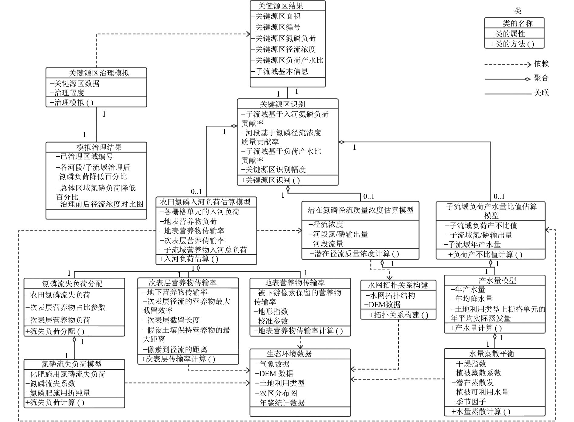
图 1 ANSP关键源区识别与治理模拟统一建模语言
注:()为开发语言中函数的结尾;数字表示各类关系中对象的数量,如0..1表示允许0~1个对象;+表示含有子项的菜单,−为菜单展开的子项。
Figure 1. Unified modelling language for the identification and control simulation of ANSP key source areas

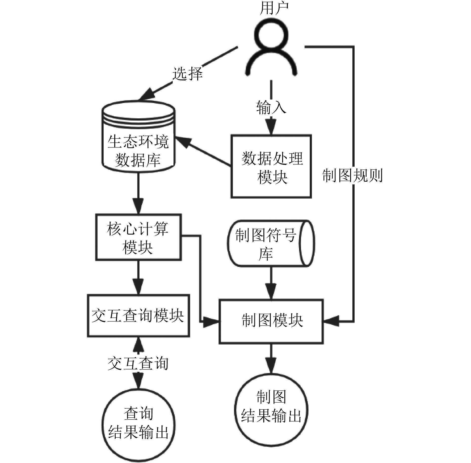
图 2 ANSP关键源区识别与治理模拟软件结构
Figure 2. Software structure diagram for identification and simulation of the treatment of ANSP key source areas
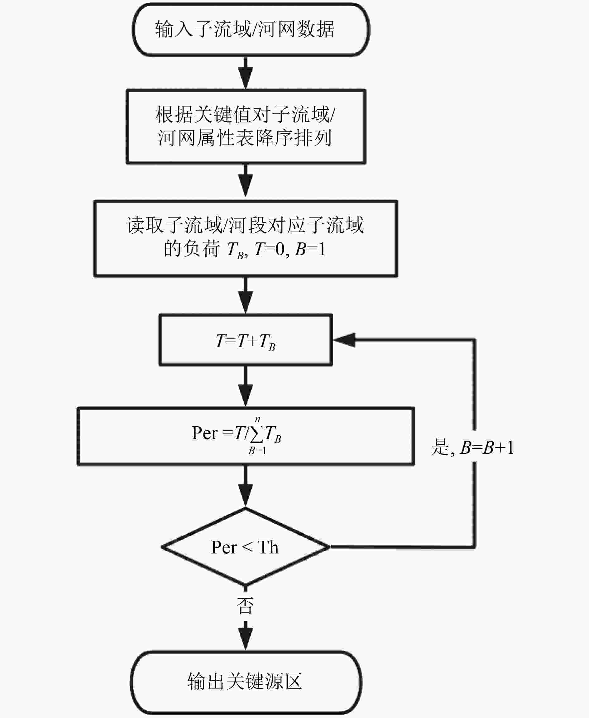
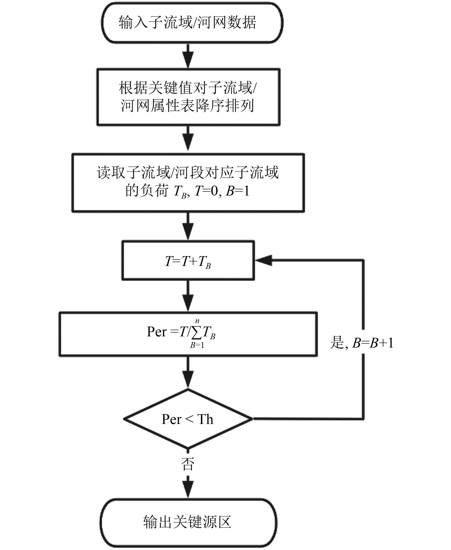
图 4 关键源区识别流程
注:T表示累加后子流域入河负荷;B表示子流域顺位序号;n表示子流域总个数;Per表示子流域累计入河负荷与流域总负荷之比;Th为设定的阈值。
Figure 4. Identification process for key source area

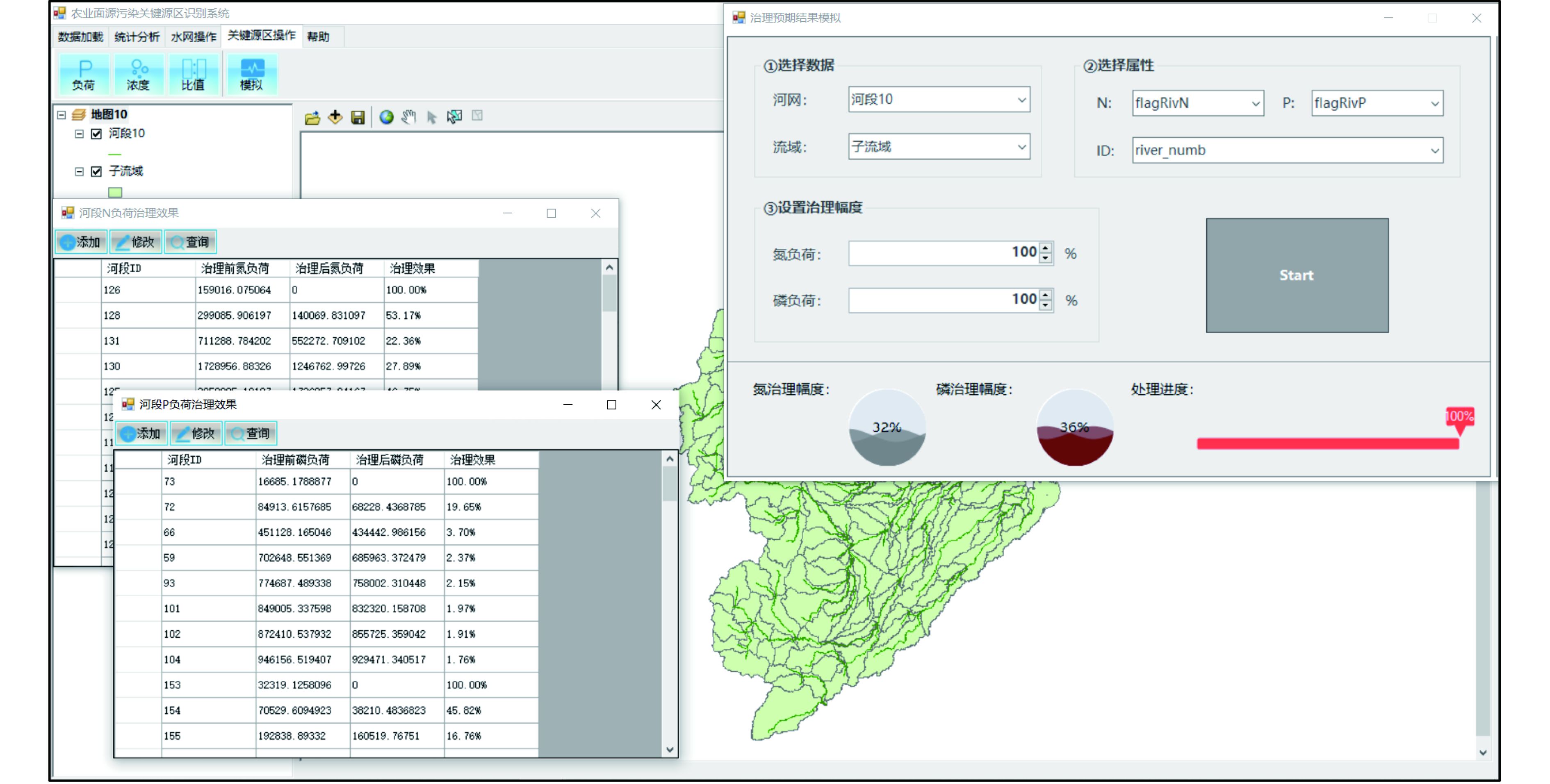
图 5 农业面源污染关键源区识别软件用户界面
Figure 5. User interface of the key source area identification software for ANSP

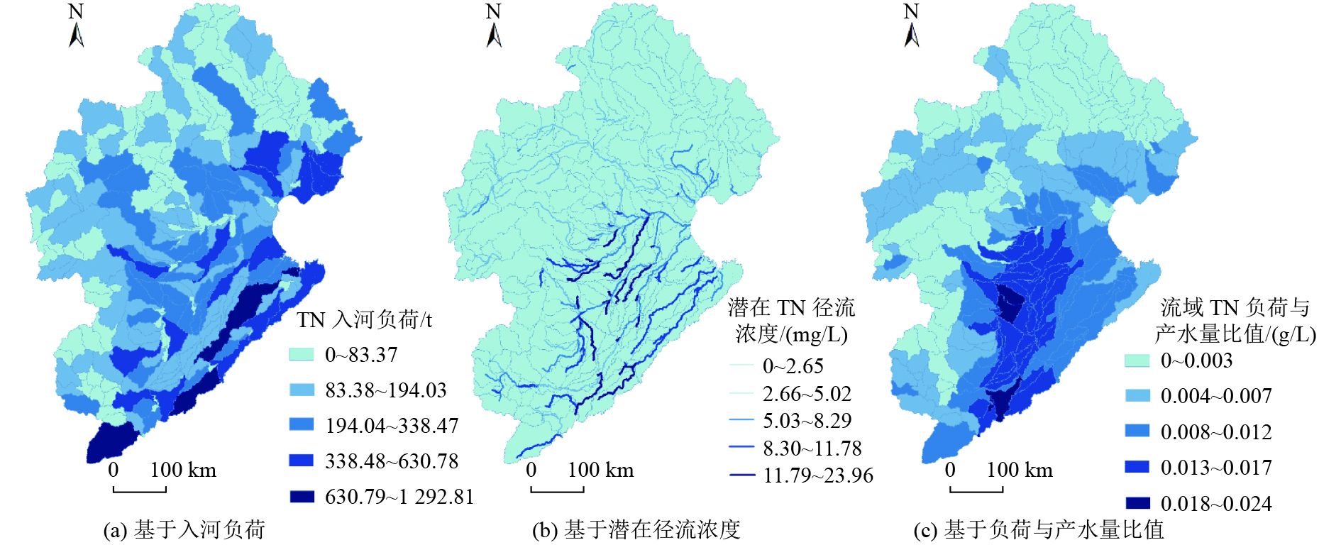
图 6 3种情景下的TN污染区域分布情况
Figure 6. Regional distribution of total nitrogen pollution under three scenarios

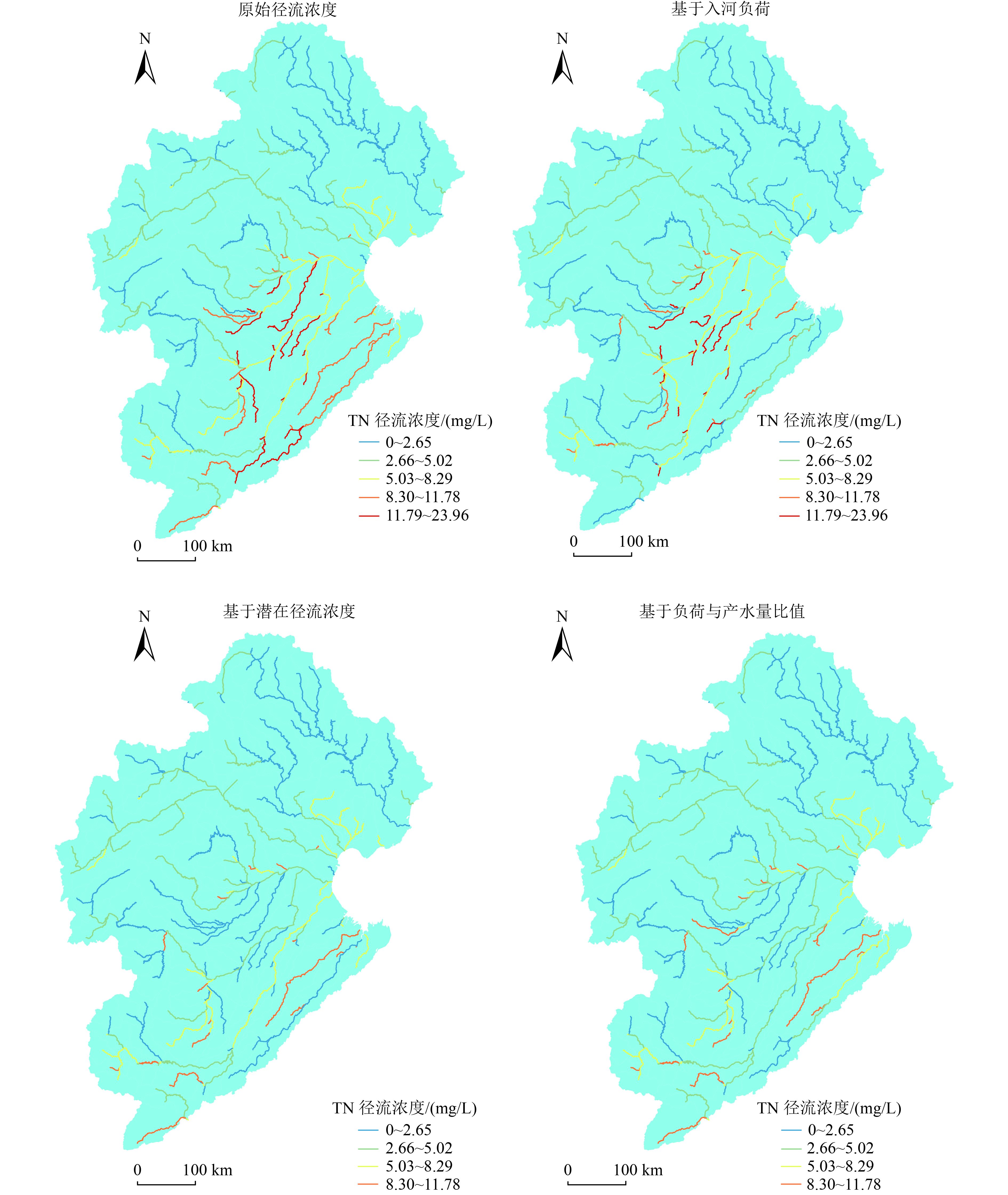
图 8 原始径流浓度与3种情景下治理效果对比
Figure 8. Comparison chart of original runoff concentration and that of three methods after treatment
表 1 3种情景下关键源区模拟治理效果
Table 1. Simulation of governance effects in key source areas under three scenarios
情景 河段TN负荷下降率/% 河段TP负荷下降率/% 基于入河负荷 19.06 26.91 基于潜在径流浓度 32.05 36.89 基于负荷与产水量比值 33.19 37.34  下载: 导出CSV
-
[1] 黄瑜, 刘佩诗, 甘曼琴, 等.GIS技术在农业面源污染研究中的应用[J]. 中国土壤与肥料,2020(6):279-285. doi: 10.11838/sfsc.1673-6257.19487HUANG Y, LIU P S, GAN M Q, et al. Application of GIS technology in research of agricultural non-point source pollution[J]. Soil and Fertilizer Sciences in China,2020(6):279-285. doi: 10.11838/sfsc.1673-6257.19487 [2] 夏昊. 基于GIS的面源信息系统及其在流溪河下游流域和增江上游流域的初步应用[D]. 广州: 中国科学院研究生院(广州地球化学研究所), 2004. [3] 乔卫芳, 牛海鹏, 赵同谦.基于SWAT模型的丹江口水库流域农业非点源污染的时空分布特征[J]. 长江流域资源与环境,2013,22(2):219-225.QIAO W F, NIU H P, ZHAO T Q. Temporal-spatial distribution of agricultural non-point source pollution in the Danjiangkou Reservoir watershed based on SWAT mode[J]. Resources and Environment in the Yangtze Basin,2013,22(2):219-225. [4] 薛卓彬. 基于InVEST模型的延河流域生态系统服务功能评估[D]. 西安: 西北大学, 2017. [5] 周慧平, 高超, 朱晓东.关键源区识别: 农业非点源污染控制方法[J]. 生态学报,2005,25(12):3368-3374. doi: 10.3321/j.issn:1000-0933.2005.12.036ZHOU H P, GAO C, ZHU X D. Identification of critical source areas: an efficient way for agricultural non-point source pollution control[J]. Acta Ecologica Sinica,2005,25(12):3368-3374. doi: 10.3321/j.issn:1000-0933.2005.12.036 [6] 环境保护部.2015年中国环境状况公报[A]. 北京: 环境保护部, 2015. [7] OUYANG W, HAO F H, WANG X L. Regional non point source organic pollution modeling and critical area identification for watershed best environmental management[J]. Water, Air, and Soil Pollution,2008,187(1/2/3/4):251-261. [8] 张巧玲, 胡海棠, 王道芸, 等.海河流域农田氮磷面源污染的空间分布特征及关键源区识别[J]. 灌溉排水学报,2021,40(4):97-106.ZHANG Q L, HU H T, WANG D Y, et al. Spatial distribution of nitrogen and phosphorus in Haihe Basin and their determinants[J]. Journal of Irrigation and Drainage,2021,40(4):97-106. [9] 蒋好忱. 流域土壤侵蚀评价中的河流拓扑分析[D]. 西安: 西北大学, 2014. [10] 苗正伟, 徐利岗, 张薇.京津冀地区参考作物蒸散量变化特征与成因分析[J]. 灌溉排水学报,2018,37(5):39-50.MIAO Z W, XU L G, ZHANG W. Spatiotemporal variation of the reference crop evapotranspiration and the factors affecting it in Beijing-Tianjin-Hebei Region[J]. Journal of Irrigation and Drainage,2018,37(5):39-50. [11] 吕乐婷, 任甜甜, 李赛赛, 等.基于InVEST模型的大连市产水量时空变化分析[J]. 水土保持通报,2019,39(4):144-150.LÜ L T, REN T T, LI S S, et al. Analysis on spatio-temporal variation of water supply in Dalian City based on InVEST model[J]. Bulletin of Soil and Water Conservation,2019,39(4):144-150. [12] YANG S Q, HAN R Y, XING L, et al. Effect of slope farmland soil and water and soil nitrogen and phosphorus loss based on different crop and straw applications and ridge patterns in the basin of the main stream of the Songhua River[J]. Acta Ecologica Sinica,2018,38(1):42-47. doi: 10.1016/j.chnaes.2018.01.007 [13] 席浩郡, 刘贝贝, 黄雅娟, 等.北京市北沙河小流域非点源氮、磷负荷估算与源解析[J]. 环境工程技术学报,2021,11(2):258-266. doi: 10.12153/j.issn.1674-991X.20200076XI H J, LIU B B, HUANG Y J, et al. Estimation and sources apportionment of non-point source nitrogen and phosphorus loads in Beishahe sub-catchment of Beijing[J]. Journal of Environmental Engineering Technology,2021,11(2):258-266. doi: 10.12153/j.issn.1674-991X.20200076 [14] 项颂, 吴越, 吕兴菊, 等.洱海流域农业面源污染空间分布特征及分类控制策略[J]. 环境科学研究,2020,33(11):2474-2483.XIANG S, WU Y, LÜ X J, et al. Characteristics and spatial distribution of agricultural non-point source pollution in Erhai Lake Basin and its classified control strategy[J]. Research of Environmental Sciences,2020,33(11):2474-2483. [15] 王国重, 李中原, 左其亭, 等.丹江口水库水源区农业面源污染物流失量估算[J]. 环境科学研究,2017,30(3):415-422.WANG G Z, LI Z Y, ZUO Q T, et al. Estimation of agricultural non-point source pollutant loss in catchment areas of Danjiangkou Reservoir[J]. Research of Environmental Sciences,2017,30(3):415-422. [16] 宋梓菡, 崔嵩, 付强, 等.哈尔滨市主城区河流污染物入河量初步估算与来源分析[J]. 灌溉排水学报,2020,39(3):134-144.SONG Z H, CUI S, FU Q, et al. Origins and estimation of the pollutants in main rivers in urban area of Harbin[J]. Journal of Irrigation and Drainage,2020,39(3):134-144. [17] WINCHELL M F, FOLLE S, MEALS D, et al. Using SWAT for sub-field identification of phosphorus critical source areas in a saturation excess runoff region[J]. Hydrological Sciences Journal,2015,60(5):844-862. [18] 朱梅, 吴敬学, 张希三.海河流域畜禽养殖污染负荷研究[J]. 农业环境科学学报,2010,29(8):1558-1565.ZHU M, WU J X, ZHANG X S. Pollutants loads of livestock and poultry breeding in Hai Basin, China[J]. Journal of Agro-Environment Science,2010,29(8):1558-1565. [19] DING X W, SHEN Z Y, HONG Q, et al. Development and test of the export coefficient model in the upper reach of the Yangtze River[J]. Journal of Hydrology,2010,383(3/4):233-244. [20] 胡正, 敖天其, 李孟芮, 等.改进的输出系数模型在缺资料地区面源综合评价[J]. 灌溉排水学报,2019,38(2):108-114.HU Z, AO T Q, LI M R, et al. Analyzing non-point pollution in areas with scarce data using modified output-coefficient model[J]. Journal of Irrigation and Drainage,2019,38(2):108-114. [21] 谢培, 宫健, 陈诚.北京市农业面源污染负荷特征分析及控制分区[J]. 环境工程技术学报,2020,10(4):613-622. doi: 10.12153/j.issn.1674-991X.20190139XIE P, GONG J, CHEN C. Analysis of pollution load characteristics and control zones division of agricultural non-point sources in Beijing City[J]. Journal of Environmental Engineering Technology,2020,10(4):613-622. doi: 10.12153/j.issn.1674-991X.20190139 [22] 刘增进, 张关超, 杨育红, 等.河南省农业非点源污染负荷估算及空间分布研究[J]. 灌溉排水学报,2016,35(11):1-6.LIU Z J, ZHANG G C, YANG Y H, et al. Estimation and spatial distribution of agricultural non-point source pollution loads in Henan Province[J]. Journal of Irrigation and Drainage,2016,35(11):1-6. [23] 傅家仪, 臧传富, 吴铭婉.1990—2015年海河流域土地利用时空变化特征及驱动机制研究[J]. 中国农业资源与区划,2020,41(5):131-139.FU J Y, ZANG C F, WU M W. Spatial and temporal variability characteristics and driving mechanism of land use in Haihe River Basin from 1990 to 2015[J]. Chinese Journal of Agricultural Resources and Regional Planning,2020,41(5):131-139. [24] 冯爱萍, 吴传庆, 王雪蕾, 等.海河流域氮磷面源污染空间特征遥感解析[J]. 中国环境科学,2019,39(7):2999-3008. doi: 10.3969/j.issn.1000-6923.2019.07.037FENG A P, WU C Q, WANG X L, et al. Spatial character analysis on nitrogen and phosphorus diffuse pollution in Haihe River Basin by remote sensing[J]. China Environmental Science,2019,39(7):2999-3008. doi: 10.3969/j.issn.1000-6923.2019.07.037 [25] HUANG J J, LIN X J, WANG J H, et al. The precipitation driven correlation based mapping method (PCM) for identifying the critical source areas of non-point source pollution[J]. Journal of Hydrology,2015,524:100-110. ⊕ doi: 10.1016/j.jhydrol.2015.02.011 -

 下载:
下载:


 点击查看大图
计量
- 文章访问数: 380
- HTML全文浏览量: 203
- PDF下载量: 50
- 被引次数: 0