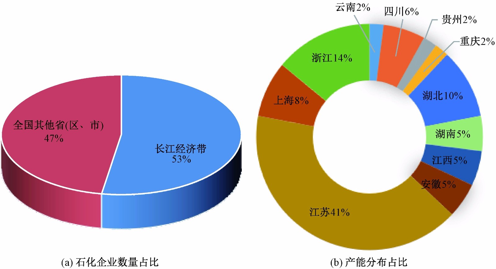
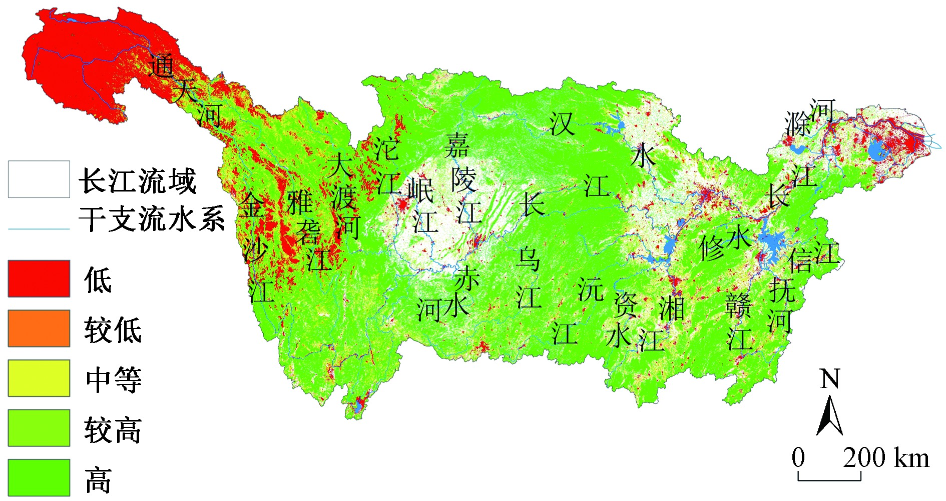
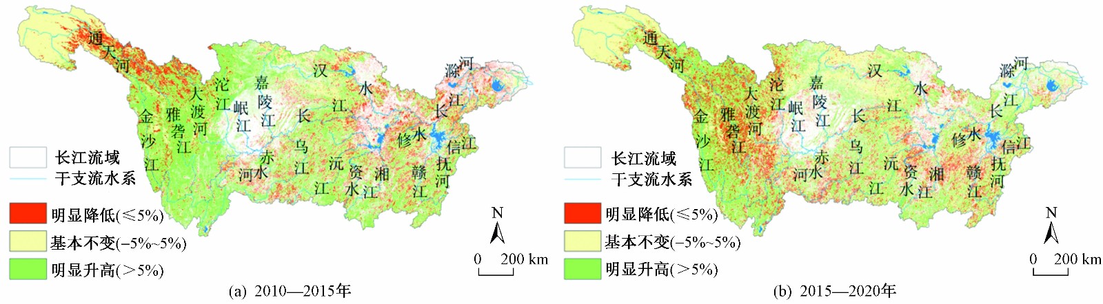
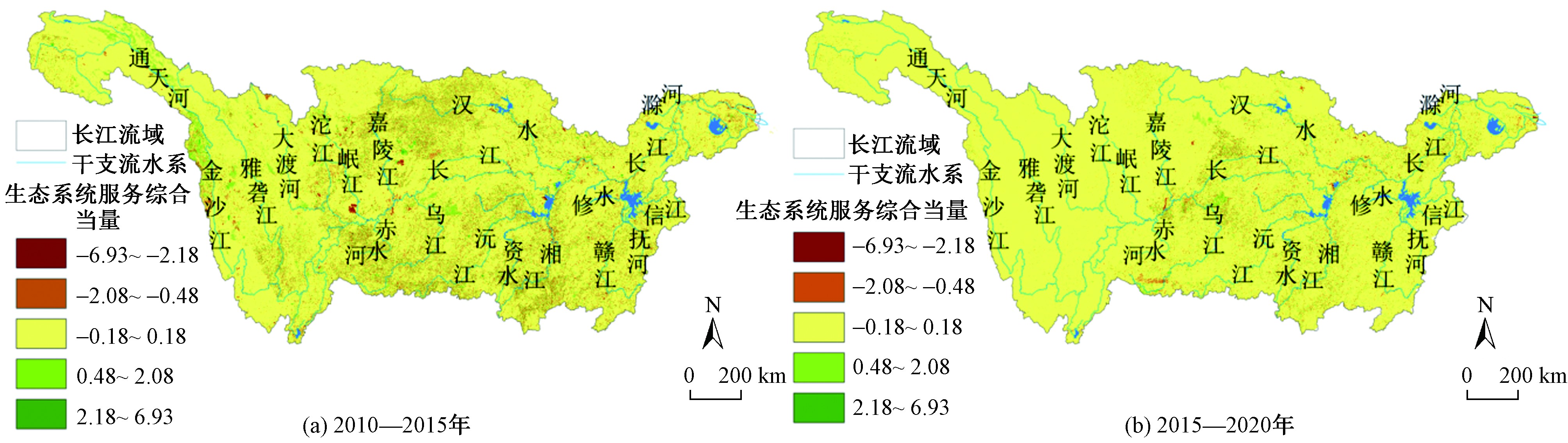
2022 Vol. 12, No. 2

Display Method:
2022, 12(2)
Abstract(527) HTML (567) PDF(193KB)(18)
Abstract:
2022, 12(2)
Abstract(206) HTML (271) PDF(218KB)(8)
Abstract:
Fighting against the battle of protection and restoration of the Yangtze River Basin to start a new chapter of ecological-oriented and green development
WANG Jinnan, SUN Hongliang, ZHAO Yue, XU Yanxue, YIN Bingchao, YANG Jingjing
2022, 12(2): 329-335. doi: 10.12153/j.issn.1674-991X.20210731
Abstract(1052) HTML (623) PDF(1399KB)(365)
Abstract:
The Yangtze River is an important ecological security barrier in China and where the economic barycenter and vitality lies. Since the 18th National Congress of the Communist Party of China, positive progress has been made in the protection and restoration of the Yangtze River under the high promotion of the CPC Central Committee and the State Council. The improvement of water quality in the Yangtze River Basin in the last decade was systematically analyzed. The current prominent issues, such as high pressure on water environment pollution control, inefficient utilization of water resources, serious water ecology damage, high risk of water environment, and urgent need to strengthen modern governance capacity, was expounded. It was put forward that it was crucial to implement the spirit of the series of speeches by General Secretary Jinping Xi on promoting the development of the Yangtze River Economic Belt and coordinate water environment governance, water resources protection, water ecological protection, water risk prevention in new era, especially during the 14th Five-Year Plan Period, which should focus on comprehensive governance, system governance and source governance, continuously improve modern governance capabilities, deeply promote the protection and restoration of the Yangtze River Basin, and tamp the foundation of multi-layer protection, in order to strenuously build an eco-development demonstration belt in which human and nature coexist harmoniously.
Focusing on water eco-environment problems and sustainably promoting ecological conservation and restoration of the Yangtze River
LI Haisheng, YANG Queping, ZHAO Yanmin
2022, 12(2): 336-347. doi: 10.12153/j.issn.1674-991X.20220091
Abstract(932) HTML (561) PDF(2958KB)(266)
Abstract:
Strengthening the protection of the eco-environment of the Yangtze River is related to the overall situation of socio-economic development in the Yangtze River Basin, which is not only an objective requirement for maintaining the eco-environmental safety of the Yangtze River Basin, but also an important part of implementing major central policies. Relying on the first phase of the joint research project on the eco-environmental conservation and restoration of the Yangtze River, the problems existing in the water eco-environment of the basin were diagnosed, the causes were analyzed, and the policy suggestions for strengthening the conservation and restoration of the water eco-environment were put forward. The main water eco-environmental problems in the Yangtze River Basin included: the decline of the river connectivity and the shrinking of the area of lakes and wetlands caused by the development of resources in the basin; the relatively large intensity of pollutant discharge, and the common deterioration of water quality during the flood season common; the degradation of water ecosystems, the frequent occurrence of lake blooms and red tides in the Yangtze River estuary and the decline in fishery resources, which meant a long way to go with the protection of rare and unique aquatic organisms; the prominent water environmental risk problems, and the frequent occurrence of sudden water pollution accidents. The causes of water eco-environmental problems in the Yangtze River Basin mainly included: the contradiction between the accelerated process of urbanization and population agglomeration and the shortcoming of the environmental infrastructures; the synergy of eco-environmental governance was still insufficient; the control and governance of territorial space was not in place; and the climate change brought new challenges. Accordingly, some countermeasures and suggestions were proposed, including strengthening territorial space management and control at the watershed level and implementing "Three Lines and One List" policy; making up for the shortcomings of infrastructure and deepening pollution prevention and control; promoting the overall planning of "Three Waters" and continuing to carry out ecological restoration; strengthening policy coordination and promoting diversified co-governance; strengthening institutional innovation and enhancing scientific and technological support capabilities, in order to provide a reference for continuing to fight the battle of protection and restoration of the Yangtze River, and for promoting the Yangtze River Economic Belt to become the main battlefield of China′s ecological priority and green development.
Study on key technologies for improving quality and efficiency of urban drainage system: a case of Ma′anshan City
XU Zuxin, ZHANG Jingyi, XU Jin, WANG Siyu, CHEN Zongqun, LIN Yiyuan, WANG Jingyi, QU Yang, YIN Hailong, LI Huaizheng, JIN Wei
2022, 12(2): 348-355. doi: 10.12153/j.issn.1674-991X.20210842
Abstract(974) HTML (569) PDF(2583KB)(335)
Abstract:
The low quality and efficiency of drainage systems are ubiquitous in cities in the middle and lower reaches of the Yangtze River, becoming a bottleneck restricting the long-term improvement of the urban water environment. Based on the Yangtze River eco-environmental protection and restoration requirements of Ma′anshan City, four key technologies for improving the water quality of the main inland river, the Cihu River, in the aspects of accurate source control, sewage interception and pollution control on rainy days were studied. The technologies included: 1) Applying the drainage outlets tracing methods based on grid water quantity and quality monitoring, and combining the inverse problem method, the main discharge areas of pollution load along the Cihu River mainstream were determined, thus fulfilling the simple and accurate sewage outlet investigation. 2) A Monte Carlo chemical mass balance model was developed based on the water quality characteristic factors to identify the mixed sewage volume and groundwater infiltration volume of rainwater pipeline in primary drainage areas of Cihu River, and the microbial genetic algorithm (MGA) was further applied to locate mixed connection and damage points. 3) Comprehensively considering the influence of multiple factors such as rainfall characteristics, sunny days in the early stage, pipeline sediments and mixed sewage, the dynamic process lines of water quality and quantity at discharge outlets were established, and the "concentration-volume" optimizing regulation and storage design based on multiple influencing factors was proposed to greatly improve the interception loads. 4) The feasibility of efficient overflow pollution control techniques based on in-situ coagulation-flocculation in the pipeline was proposed and explored. Through the scientific and technological support and the efforts of all parties, the water quality in the Cihu River, Ma′anshan City, had been steadily improved, which provided a reference for further improving the effectiveness of urban water environment comprehensive treatment in the middle and lower reaches of the Yangtze River.
Some thoughts on the scientific support to the eco-environmental management of the Yangtze River under Great Protection of the Yangtze River
LI Chong, LI Wei, ZHOU Ruimeng, XIA Qing
2022, 12(2): 356-360. doi: 10.12153/j.issn.1674-991X.20210696
Abstract(1219) HTML (536) PDF(445KB)(757)
Abstract:
The ecological environmental problems of the Yangtze River follow the rules of "symptoms in the water, lesions on the shore and root causes in the structure". The upstream areas mainly face the problem of developing in protection, the midstream areas face the problem of protecting in development, while the downstream areas need to open up a new level of mutual benefit between protection and development. The joint research on the protection and restoration of the eco-environment of the Yangtze River is an innovative model for Ministry of Ecology and Environment and China Three Gorges Corporation (CTG) to carry out strategic cooperation and innovation between the ministry and enterprises. The 14th Five-Year Plan to carry out joint scientific and technological research on the protection of the Yangtze River requires in-depth research on the relationship between environment and economic development, the relationship between major projects and Great Protection of the Yangtze River, and the relationship between pollution prevention systems and ecological management. It is necessary to focus on the three major pollution sources of industry, agriculture and cities, strive to overcome difficulties and pass through the barriers, to accomplish the supporting role of science and technology, so as to better protect the Yangtze River.
Surface water quality and correlation analysis of the Yangtze River Economic Belt during the 13th Five-Year Plan period
CHEN Shanrong, DONG Guangxia, ZHANG Fengying, LI Yilong, ZHOU Mi, MA Guangwen, HE Lihuan, LIN Lanyu
2022, 12(2): 361-369. doi: 10.12153/j.issn.1674-991X.20210782
Abstract(288) HTML (217) PDF(5101KB)(53)
Abstract:
Based on the National Surface Water Environmental Quality Monitoring Network, the monitoring data of 1 178 comparable sections in the Yangtze River Economic Belt (YREB) during the 13th Five-Year Plan period were derived and sorted. Combined with the data of population, social economic and pollutant discharges, the correlations between the variation of water quality and various socio-economic development indicators in YREB were analyzed. The results showed that during the 13th Five-Year Plan period, the surface water quality of YREB had improved steadily, and the water quality was good. The water sections meeting Grade Ⅰ-Ⅲ of Environmental Quality Standards for Surface Water (GB 3838-2002) had increased from 76.2% to 86.5%, while the sections that were inferior to Grade V standard had decreased from 3.7% to 0.4%. The concentrations of total phosphorus (TP), chemical oxygen demand (COD) and ammonia nitrogen (NH3-N), which were the main over-standard indexes of surface water quality in YREB, decreased by 32.4%, 10.9% and 53.3%, respectively. The concentrations of TP, COD and NH3-N in the downstream provinces (municipalities) such as Anhui, Jiangsu and Shanghai were relatively high, and the concentrations of TP, COD and NH3-N in some individual sections increased. The biggest driving factors leading to the change of waste/sewage discharge were the population, the proportion of secondary industry, and the discharge of main pollutants. During the 13th Five-Year Plan period, the state further strengthened the water environment treatment of YREB. The operation cost for waste water treatment facilities increased year by year, up by 30.2%. The water environment treatment in YREB achieved remarkable results. However, the pressure from socio-economic development and pollution discharge still existed. To ensure the continuous improvement on the water environment in YREB, further improvements on the quality and efficiency were needed.
Identification and prevention and control suggestions of heavy chemical industry risks in the Yangtze River Economic Belt
ZHANG Di, CAO Hongbin, ZHAO He, SHI Yanchun
2022, 12(2): 370-379. doi: 10.12153/j.issn.1674-991X.20210653
Abstract(276) HTML (186) PDF(1197KB)(36)
Abstract:
The heavy chemical industry risks in the Yangtze River Economic Belt were systematically analyzed from the multi-level perspectives of basin, industry, region and city, including layout risk, local sudden accident risk, the cumulative risk of pollution emission, and the potential chronic risk of toxic and harmful pollutants, etc. Based on the current situation analysis and risk assessment of heavy chemical industry in the typical regions of the Yangtze River Economic Belt, the heavy chemical industry layout and risk prevention and control schemes were formulated and the policies of classification and zoning implemented, according to the overall characteristics of the basin and various industries/regions. The schemes included hierarchical dynamic management and classified management of existing and new parks. In addition, some precise prevention and control options were also proposed, including implementing cross-department and regional collaborative prevention and control to deal with the environmental risks of sudden accidents, realizing management-technology synergy to prevent cumulative outbreak risk, and coordinating river basins and industry types to perform prevention and control for the potential chronic risks. The study could provide systematic solutions and control technologies for heavy chemical industry risks for typical regions and stationary cities in the Yangtze River Economic Belt, so as to promote high-quality green development of the Yangtze River Economic Belt.
Evaluation of ecological civilization construction level of national ecological civilization construction demonstration zones in the Yangtze River Economic Belt
CHAI Yingying, MENG Xiaojie, HAN Yongwei, YE Lufeng, LEI Shuo
2022, 12(2): 380-389. doi: 10.12153/j.issn.1674-991X.20210697
Abstract(256) HTML (198) PDF(2359KB)(33)
Abstract:
In order to study the ecological civilization construction level of the first batch of national ecological civilization construction demonstration zones (NECCDZs) in the Yangtze River Economic Belt, and to provide guidance for future ecological civilization construction work, six key indicators in ecological environment, economic and social aspects were selected to analyze the temporal and spatial trends of the development of NECCDZs. The results showed that all the 6 indicators could basically achieve steady improvement in each NECCDZ. By 2019, the number of NECCDZs whose indicator values were better than the average indicator value of the corresponding province (city) accounted for 81.25%, 87.50%, 87.50%, 68.75%, 90.91%, 56.25%, respectively. The ecological environment, economy and society coordination model was established to divide the 16 NECCDZs in the Yangtze River Economic Zone into four types. Then, the ecological environment, economic and social coordinated development status of the NECCDZs in 2017 and 2019, as well as the problems of focusing on improvement of the ecological environmental quality while the socio-economic development was slow, or focusing on the socio-economic improvement while the improvement of the ecological environment slowed down, were analyzed. The results showed that the coordinated development of ecological environment, economy and society in most NECCDZs had improved in some degree. By 2019, 31.25% of the 16 NECCDZs had a high degree of harmonious development, 17.65% of them had a lower ecological environment, economic and social development, while 51.10% only focused on one aspect, with low development coordination of ecological environment, economy and society.
Research on AHP-TOPSIS technology applicability evaluation method based on water pollution treatment target demand
LIANG Jiahao, WANG Zhenbei, ZHU Hongtao, SUN Dezhi
2022, 12(2): 390-398. doi: 10.12153/j.issn.1674-991X.20210713
Abstract(394) HTML (244) PDF(1952KB)(67)
Abstract:
A set of technology applicability evaluation method was constructed according to the differentiated needs of water pollution treatment goals. In the index system constructed for technology screening and evaluation, the water pollution treatment goals should be decomposed into evaluation indexes, and the performance indexes of the technology itself should be included. Then, Analytic Hierarchy Process (AHP) was used to assign weight to each index in the index system, and the comprehensive performance of the alternative technologies was evaluated by using Technique for Order Preference by Similarity to Ideal Solution (TOPSIS) method, so as to screen out the adaptive recommended technologies that met the needs of water pollution treatment objectives. This method was applied to the case studies of a sponge city construction and a black and smelly water treatment project, to investigate whether the technical applicability evaluation method constructed in this study could achieve the expected effect. Due to the different governance objectives and needs, the technical evaluation index system and the weight of evaluation index were different in these two case and, as a result, the suitability recommended technologies screened from the same technology library were not consistent. This indicated that the AHP-TOPSIS technology applicability evaluation method could be used to screen the adaptive recommended technologies according to the differences of water pollution governance objectives and needs.
Ecological products value realization mechanism and effectiveness evaluation in the Yangtze River Basin
LEI Shuo, MENG Xiaojie, HOU Chunfei, YE Lufeng, DENG Haodan, CHAI Yingying, HAN Yongwei
2022, 12(2): 399-407. doi: 10.12153/j.issn.1674-991X.20210690
Abstract(368) HTML (246) PDF(934KB)(54)
Abstract:
To promote the coordination of ecological protection and economic development in the Yangtze River Basin, it is very necessary to explore and establish the value realization mechanism of ecological products. Starting from the three aspects of ecological products protection, value transformation and guarantee mechanism, the comprehensive index evaluation system was constructed for the value realization effect of ecological products, and the effect and existing problems of ecological products value realization in 37 typical cities (prefectures) in the Yangtze River Basin was comprehensively analyzed. The results showed that the total index of value realization effect of ecological products was 70.48 on average, and the sub-indexes of protection effect, transformation effect and guarantee mechanism were 83.48, 57.61 and 70.32, respectively. The ecological products protection effect was good, while the efficiency of value transformation was low and the relevant guarantee mechanism needed to be strengthened. The overall effect of ecological products value realization in the upstream area was better than that in the middle and lower reaches, the value transformation effect of ecological products in the middle reaches was better, and the guarantee mechanism in the lower reaches was better. Accordingly, some countermeasures and suggestions were put forward, including strengthening ecological protection and restoration, strengthening the development of premium value of ecological products, and improving the guarantee mechanisms of value accounting, social participation, promotion and coordination of ecological products, etc.
Changes of land use and ecosystem service in the Yangtze River Basin after five years' general protection
WANG Dewang, HE Ping, XU Jie, WANG Jiawen
2022, 12(2): 408-416. doi: 10.12153/j.issn.1674-991X.20210687
Abstract(397) HTML (219) PDF(3082KB)(39)
Abstract:
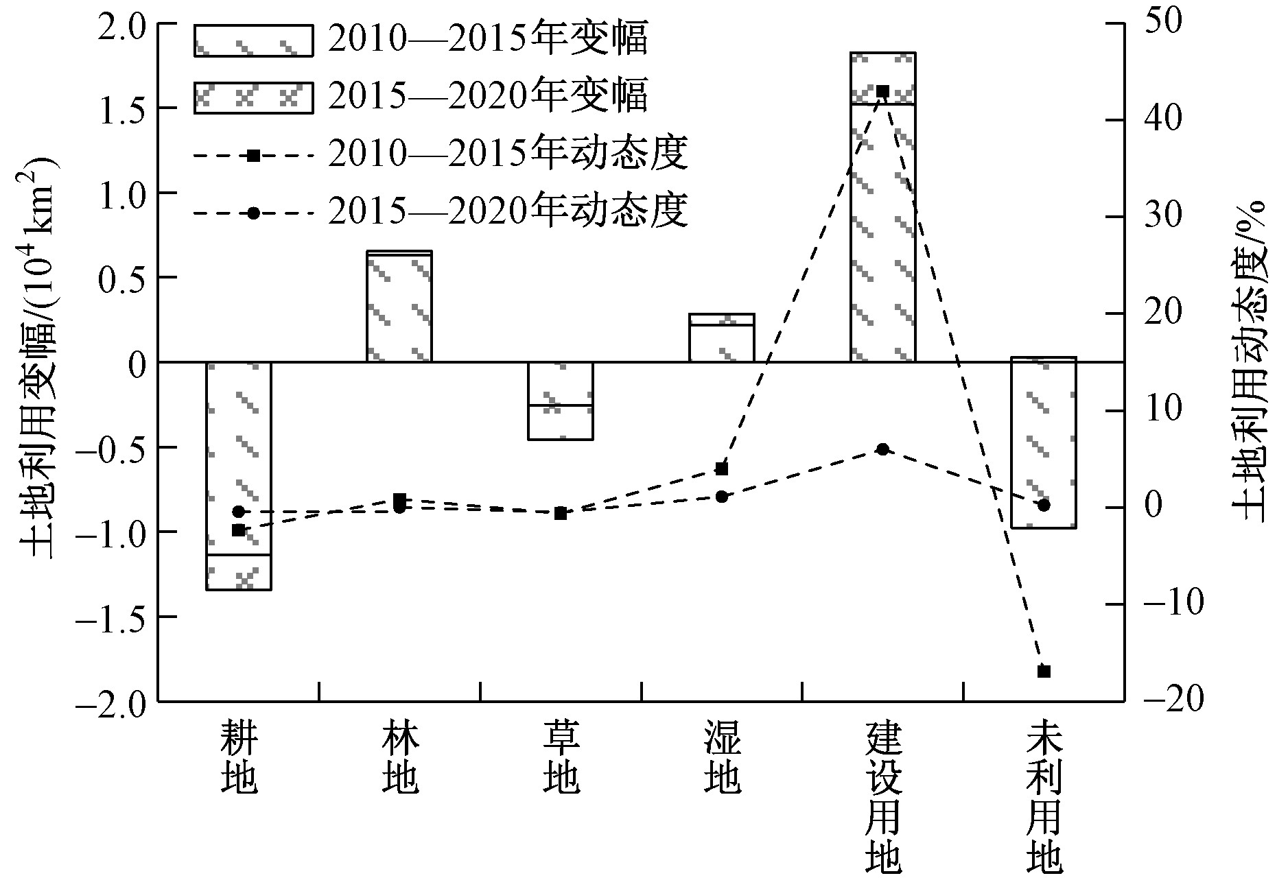
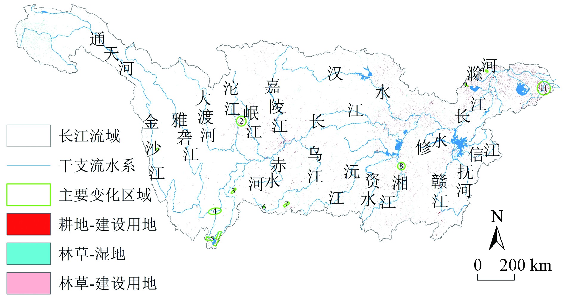
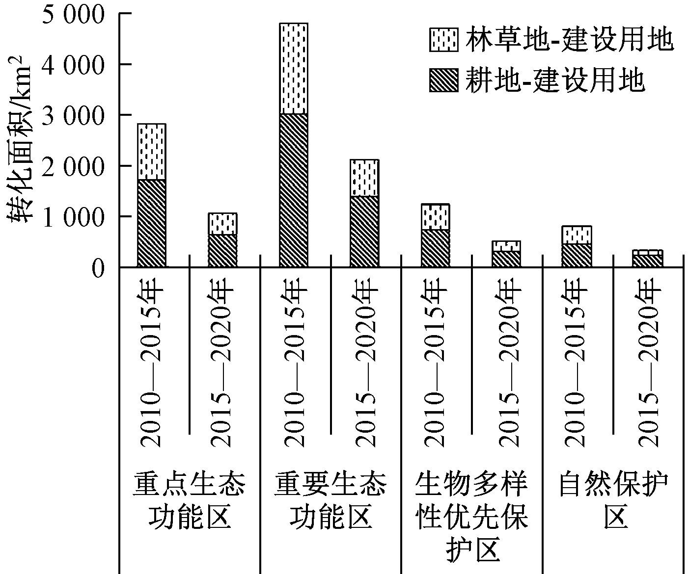
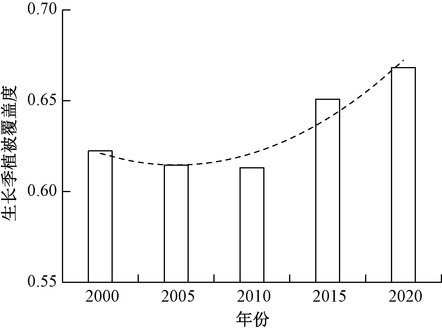
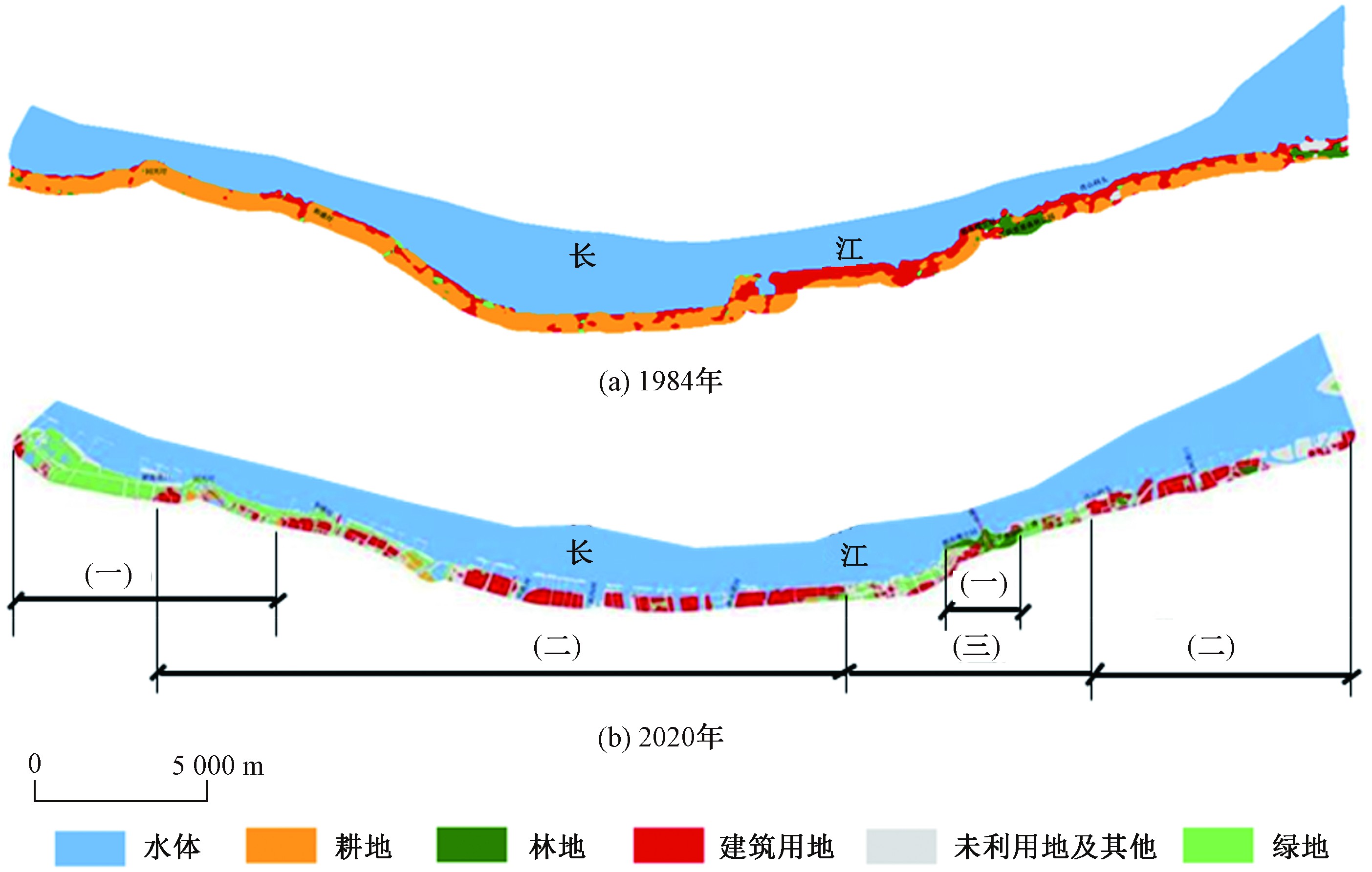
China began to implement the great protection strategy of the Yangtze River in 2016, and a series of measures for ecological protection and restoration such as shelter forest construction, port and wharf regulation and shoreline restoration had been carried out. Based on the land use data interpreted by remote sensing in 2010, 2015 and 2020, the changes of land use and ecosystem service in the Yangtze River Basin (YRB) were compared and analyzed. The changes of land use and the distribution of ports and wharfs on the coastal buffer zone of rivers and lakes were also analyzed to jointly reflect the effectiveness of the general protection of the Yangtze River. The results showed that: 1) From 2015 to 2020, the conversion of land use was mainly cultivated land, forest and grassland to construction land in the six urban agglomerations, important protected areas and the buffer zones of key rivers and lakes of the Yangtze River Economic Belt. Compared with the previous five years, comprehensive dynamic degree of ecosystem, ecological land use change index and the development interference index in the YRB were declining, and the change amplitude and dynamics of land use were becoming gentle. 2) From 2015 to 2020, the total area of forest, grassland, cultivated land and unused land decreased, while that of wetland and construction land increased in the buffer zone of key rivers and lakes (0-5 km). Compared with the previous five years, the change of total number and area of port and wharf in riparian zone had converted from obvious increase to decrease. 3) From 2015 to 2020, the vegetation coverage of the growing season showed an upward trend in the YRB. Compared with the previous five years, the area of high-level vegetation coverage steadily increased, and lower, medium and higher levels steadily reduced. 4) From 2015 to 2020, the area and quality of ecological land were basically stable. Compared with the previous five years, the change of comprehensive equivalent of ecosystem service had converted from slight increase to be stable, and tends to be gentle.
A preliminary analysis of the ecosystem structure and function of the Yangtze Estuary based on Ecopath model
WANG Dianchang, WU Xinghua, DING Ling, ZHANG Mengsheng, XIE Han, ZHANG Qin, LI Song
2022, 12(2): 417-425. doi: 10.12153/j.issn.1674-991X.20210714
Abstract(400) HTML (166) PDF(1293KB)(51)
Abstract:
Based on the survey data of the Yangtze Estuary fishery resources and ecological environment survey in spring (May) and autumn (November) in 2020, the Ecopath model of the Yangtze Estuary ecosystem was established to analyze the ecosystem structure and energy flow characteristics of the Yangtze Estuary before the total fishing ban of the Yangtze River. The model consisted of 17 functional groups, including Harpadon nehereus, Coilia mystus, Coilia nasus, tongue sole, zooplankton feeding fish, benthic feeding fish, swimming feeding fish and omnivorous fish, which basically covered the energy flow process of the Yangtze Estuary ecosystem. The results showed that the trophic level of the Yangtze Estuary ecosystem ranged from 1.000 to 4.438, with the highest trophic level of Harpadon nehereus and the trophic level of other fish ranging from 2.907 to 3.768, which was widely distributed. The trophic levels of benthos, molluscs, shrimp and crabs were concentrated from 2.365 to 2.826. The energy flow distribution of each trophic level in the Yangtze Estuary ecosystem mainly concentrated in trophic level Ⅰ to Ⅱ, and the energy flow from trophic level I accounted for the highest proportion of the total energy flow in the system. The energy flow of the Yangtze Estuary ecosystem was mainly transferred by the grazing food chain. Compared with the past, TPP/TR value of the Yangtze Estuary ecosystem in 2020 was higher, while CI value and SOI value increased, but were still less than 1, indicating that the Yangtze Estuary ecosystem was still immature and in the development stage.
Effects of stratified density flow on the spatial distribution of chlorophyll-a in phytoplankton in Xiangxi River
ZENG Yiheng, SHEN Xuzhou, ZHANG Jialei, ZHANG Huan, LIU Defu, GONG Chuan, WENG Chuansong
2022, 12(2): 426-435. doi: 10.12153/j.issn.1674-991X.20210808
Abstract(183) HTML (158) PDF(2104KB)(17)
Abstract:
The spatial distribution characteristics of chlorophyll-a (Chla) in phytoplankton in the Xiangxi River during the flood season and their relevant affecting factors were analyzed by applying mathematical statistics methods and based on the monitoring data of hydrodynamics, meteorology and the drifting of the algae in Xiangxi River reservoir of the Three Gorges Reservoir during the flood season (August 4-10, 2017). The process of horizontal transport and vertical mixing of algae under the background of stratified density flow was explored. The results showed that: 1) The hydrodynamic data of Xiangxi River reservoir was featured with the obvious density-stratified flow. Reynolds numbers during the monitoring period were all above 4 000, and the water body got into the turbulent state, which produced two effects on the movement of the algae, i.e. horizontal movement and vertical mixing. 2) The horizontal drift velocities of the algae on the water surface was affected by wind speeds and water velocities with the response formula Valgae=0.035Vwind+0.461Vwater+0.034 (R2=0.917, P<0.01). 3) The dilution effect of density-stratified flow on the raw water of high-concentration of algal cells in the reservoir and the carrying effect of circulations on high-concentration algal cells led to a linear downward trend of the total Chla concentrations of the water column. Meanwhile, the mainstream poured back into the reservoir at the upper and middle layers, and the upstream inflow flowed to the river mouth in the form of density current at the bottom along the slopes. The two flows met in the middle and upper sections of the river and thus a circulation was formed, and the pouring-back flow was divided into two parts in the middle of the reservoir, which were respectively discharged from the surface and the bottom. Chla concentrations presented such a sequence: surface > bottom > middle. When the circulation was formed as a result of the clash between the flow poured back and the raw water of the reservoir and discharged from the bottom to the reservoir bay, Chla concentrations presented this sequence: surface > middle > bottom, or middle > bottom > surface. The results suggested that the wind speeds and water horizontal velocities of density flow were key factors for the horizontal distribution of Chla, while the vertical distribution was affected by the water circulation mode formed by density flow.
Evaluation of ecological resilience of Hanjiang River Basin based on vegetation index
ZHANG Zhimiao, LIU Xiaofu, QIU Wenting, LUO Lei, LIU Baiyin, WANG Ying
2022, 12(2): 436-442. doi: 10.12153/j.issn.1674-991X.20210686
Abstract(330) HTML (234) PDF(4559KB)(27)
Abstract:
Based on the Enhanced Vegetation Index (EVI) data of each year from 2001 to 2020, the change of vegetation cover in the Hanjiang River Basin was analyzed, and the slope of EVI change of 150000 1 km×1 km basic units was calculated in 2001-2010, 2001-2011, 2001-2012 and 2001-2020 in the Han River Basin. The exponential decay method was used to fit the time when the change slope of EVI maintained a positive and negative trend, and the ecological resilience of the whole Hanjiang River Basin and 564 sub-basins was analyzed to evaluate the stability and sustainable development level of the ecosystem. The results showed that the EVI value of Hanjiang River Basin increased by 12.3% from 2001 to 2020, and the vegetation coverage of Hanjiang River Basin was getting better year by year. The overall ecological resilience of Hanjiang River Basin was good, and the decay time difference between the grid with a positive trend and the grid with a negative trend was 65.3 years. The ecological resilience of Hanjiang River Basin generally presented the distribution characteristics of high in the upper reaches and low in the middle and lower reaches.
Research on calculation method of ecological flow of Rangdu River based on SWAT model
XIE Pei, FANG Yuan, ZHANG Lei, SUN Ning, HUANG Faming, QIAO Fei
2022, 12(2): 443-448. doi: 10.12153/j.issn.1674-991X.20210693
Abstract(328) HTML (176) PDF(892KB)(25)
Abstract:
Ensuring and managing the ecological flow of rivers and lakes is an essential requirement for strengthening the management and control of the development and utilization of water resources, and is an important part of the implementation of "Great Protection of the Yangtze River" and "high-quality development". A method for calculating ecological flow of rivers without measured runoff was proposed, with the Rangdu River taken as an example. Firstly, the monthly runoff process from 1990 to 2019 was simulated by SWAT hydrological model. The results showed that the runoff gradually increased from upstream to downstream, and presented obvious characteristics of flood season and non-flood season. Secondly, the ecological flow of the key control sections in the mainstream was calculated by four hydrological methods, e.g. Tennant method, minimum monthly average flow method, driest monthly average flow method in recent 10 years, and flow-duration curve method. The calculated ecological flow ranged from 10% to 33%, with the calculated flow trend in the order of flow-duration curve method > driest monthly average flow method in recent 10 years > minimum monthly average flow method >Tennant method. Finally, through water quality compliance accounting, it was concluded that the recommended method for calculating the ecological flow in the river was the flow-duration curve method, accounting for about 30% of the average annual flow.
Spatial characteristics and influencing factors analysis of total phosphorus discharges in Tuojiang River Basin
LIU Dandan, QIAO Qi, LI Xueying, ZHANG Yue, BAI Lu
2022, 12(2): 449-458. doi: 10.12153/j.issn.1674-991X.20210600
Abstract(359) HTML (207) PDF(2656KB)(46)
Abstract:
Total phosphorus (TP) discharge reduction in Tuojiang River Basin plays an important role in improving water eutrophication in the Three Gorges Reservoir and the Yangtze River Basin. Taking 2017 as the base year, based on TP discharge data of industrial, agricultural and domestic sources in Tuojiang River Basin, the spatial characteristics and contribution rate of pollution sources of TP discharge were analyzed. By introducing the inflow coefficient, TP discharge into the river in Tuojiang River Basin was calculated and the metabolic pathways of TP were analyzed. Pearson correlation analysis and linear regression analysis were used to reveal the main influencing factors of TP discharge. The results showed that TP discharge and TP into the river were 8324.0 and 3676.9 t in Tuojiang River Basin in 2017, respectively. In terms of river inflow, TP discharge was the largest in Chengdu, followed by Yibin and Luzhou. Livestock breeding was the most significant anthropogenic source of TP emissions, followed by followed by crop farming and urban life. At the stage of entering the river, the TP emissions into the river were the largest in Chengdu, followed by Yibin and Leshan. Urban life was the most significant anthropogenic source of TP discharge into the river, followed by livestock breeding and rural life. Paddy field area, gross domestic product and population size were the main factors affecting TP discharge in Tuojiang River Basin.
Characterization of the spatio-temporal variations of total phosphorus concentrations and influencing factors analysis in Tuojiang River Basin, an upstream tributary of the Three Gorges Reservoir
LIU Qiang, ZHANG Peng, SHI Zhen, ZHANG Qiuying, ZHANG Dan, ZHOU Miao, LI Fadong
2022, 12(2): 459-467. doi: 10.12153/j.issn.1674-991X.20210086
Abstract(275) HTML (158) PDF(2607KB)(41)
Abstract:
The Tuojiang River is an important inflow river and the primary sources of total phosphorus (TP) in the upper reaches of the Three Gorges Reservoir. The study on the spatio-temporal variation characteristics and causes of TP concentrations in Tuojiang River Basin is important for the up-to-standard control of allowable throughput of TP in the Three Gorges Reservoir and the control of TP pollution in the basin. Based on the water quality data of 20 national and provincial monitoring sections of the trunk and tributaries in Tuojiang River Basin and pollution source data in the confluence area, the spatio-temporal distribution characteristics and influencing factors of TP concentrations in Tuojiang River Basin were comprehensively analyzed, using statistical methods, including correlation analysis, single factor analysis, and hierarchical cluster analysis. The results showed that from 2011 to 2018, the pollution of TP in Tuojiang River Basin had spread from the upper reaches of Mianyuan River, Shiting River, Duck River and the middle reach of Fuxi River to the entire basin. TP in the upper mainstream of Tuojiang River was primarily affected by the inflow of tributaries with serious TP pollution. TP concentrations increased continuously along the mainstream of Tuojiang River and reached the maximum in Sanhuangmiao section with (0.251±0.213) mg/L. TP concentrations floated in the middle and downstream reaches with concentration peaks occurred at sections of Yinshanzhen ((0.194±0.048) mg/L) and Damozi ((0.232±0.057) mg/L). TP concentrations in the flood seasons were higher than those in the dry seasons. The differences of TP concentrations between the flood and the dry seasons were significant with P<0.05. Non-point sources pollution contributed more on TP in Neijiang, Zigong, and Luzhou sections in the middle and lower reaches of Tuojiang River Basin. Point sources discharges mainly affected TP concentrations in Chengdu and Ziyang sections of the upstream trunk stream and tributaries in Neijiang and Zigong.
Calculation of water environmental capacity of ammonia-nitrogen and total phosphorus in Laodao River Basin of the Xiang River
ZHANG Qinghuan, TAN Fenfang, WU Zhaohui, HUANG Guoxian, LIU Fuzhen, DENG Yixiang
2022, 12(2): 468-476. doi: 10.12153/j.issn.1674-991X.20210101
Abstract(226) HTML (128) PDF(1690KB)(35)
Abstract:
The quantitative calculation of water environmental capacity is a prerequisite for the fine management of water environment. However, the parameters and their changes are hard to ascertain, especially in middle and small-scale catchments with insufficient datasets, which bring uncertainties to the calculation of water environmental capacity. The distributed hydrologic model and the one-dimensional (1-D) river network model can solve some parameters, thus improving the calculation accuracy of water environmental capacity. A representative catchment in the Chang-Zhu-Tan area, the Laodao River catchment, which is one of the first-level tributaries of the Xiang River Basin, was chosen. The distributed hydrologic model and the 1-D river network model were constructed, and then the water environmental capacity and remaining environmental capacity of different control units were solved, combined with the calculation formula of water environment capacity. The results showed that the distributed hydrologic model performed well in simulating streamflow, which provided vital hydrologic parameters necessary for calculating water environmental capacity. Second, the discharges of ammonia nitrogen exceeded water environmental capacity at control units of outlets of Jinjing and Baisha sections, while the other control units had pollutant discharges lower than their water environmental capacity. In the upper and lower reaches of the Laodao River Basin, the remaining environmental capacity of total phosphorus at the control units approximated 0, while in the middle reaches of the river, the remaining environmental capacity of several control units was negative, and some pollutants should be reduced. The study provided a reference method for calculating water environmental capacity in areas with a lack of data.
Water environment status and causes analysis of Chong'an River Basin in Qiannan Prefecture
MA Huan, JI Wei, FENG Chaoyang, LI Fujie, JIANG Cheng, SONG Ting, YANG Jiao
2022, 12(2): 477-484. doi: 10.12153/j.issn.1674-991X.20210692
Abstract(291) HTML (172) PDF(3065KB)(20)
Abstract:
The change characteristics of water environmental quality of Chong'an River Basin in Qiannan Prefecture were studied at the watershed scale, and the water environmental status of the watershed was comprehensively analyzed. The results showed that the water quality of Chong'an River Basin in Qiannan Prefecture was generally poor before 2018. For the trunk stream, except for the section of Heitang Bridge, all other sections eliminated the water body inferior to Grade Ⅴ in 2018. In terms of tributaries, Wuliqiao section was better than Grade Ⅲ in 2019, and the downstream of Chuanheng's outfall section was better than Grade Ⅲ in 2020. The results showed a pronounced spatiotemporal heterogeneity of water environment quality, and the water quality in the upstream was overall better than that in the downstream. In terms of pollutants, total phosphorus in all the sections and fluoride in some sections exceeded the standard. In 2015, the total phosphorus in Fengshan bridge section was the highest with 17.3 mg/L. The analysis showed that agricultural sources contributed the most to the water environment pollution in the basin. In the end, the comprehensive management measures for the basin were put forward, such as continuously promoting key pollution source control projects, strengthening water ecological restoration and control measures, and strengthening joint prevention and control of water environment in Chong'an River basin.
Problems analysis based on the response of water quality to pollution sources in Xiangxi River Basin
SHEN Zhenling, ZHOU Feng, SUN Yidian, ZHANG Wanshun, LIN Haibo, WANG Qi, LI Longyuan, YANG Lina
2022, 12(2): 485-492. doi: 10.12153/j.issn.1674-991X.20210712
Abstract(296) HTML (198) PDF(1884KB)(38)
Abstract:
Analysis of the causes of water environment problems is the key way to support the water environment fine-management and water eco-environment recovery in the river basins. The Air-ground-water integrated model system was applied to establish the response model of water quality to pollution sources in Xiangxi River Basin, and the water environment problems in the basin were quantitatively analyzed. The model was verified according to the measured data of the water quality monitoring sections in 2019, and the relative error of total nitrogen (TN) and total phosphorus (TP) concentrations were within 10%. The results showed that sewage treatment plants, industrial enterprises and livestock breeding were three main sources of water pollution and eutrophication of Xiangxi River Basin, with a total contribution rate of more than 60%. For Sixiangxi section, TN and TP discharge from sewage treatment plants were 193.28 and 40.51 t/a, with 226.25 and 31.69 t/a from industrial sources, and 187.75 and 29.82 t/a from livestock breeding, respectively. For Changshaba section, TN and TP produced by sewage treatment plants were 376.31 and 48.97 t/a, with 295.30 and 39.91 t/a from industrial sources, 128.09 and 41.61 t/a from livestock breeding, respectively. Based on the urgent needs of comprehensive water environment management, the efforts to control pollution of these three kinds of sources should be intensified in the future.
Problems and countermeasures for water ecological environment protection of small and medium-sized rivers in Chengdu-Chongqing area
WEN Quan, MA Yingqun, QIN Yanwen, CHI Minghui, ZHANG Lei, SHI Yao, CAO Wei, REN Chunping, ZHAO Li
2022, 12(2): 493-499. doi: 10.12153/j.issn.1674-991X.20210639
Abstract(380) HTML (206) PDF(1391KB)(46)
Abstract:
To further protect the water eco-environmental quality in Chengdu-Chongqing area and build a strong ecological security barrier in the upper reaches of the Yangtze River, the problems existing in the water environmental protection of small and medium-sized rivers were analyzed based on the pollution characteristics of water quality in Chengdu-Chongqing area. Countermeasures were put forward to strengthen the water environmental protection of small and medium-sized rivers. The results showed that: 1) The water quality in Chengdu-Chongqing area was gradually improving. The water pollution was mainly concentrated in small and medium-sized rivers, especially in the transboundary rivers, where the water quality exceeded the standard frequently. The water quality pollution of small and medium-sized rivers in the region mainly appeared from February to June, indicating that the regional water quality was jointly affected by the point source pollution and the non-point source pollutants which were flowed into the river with the initial rainwater. 2) The main reasons for the prominent water quality pollution of small and medium-sized rivers in Chengdu-Chongqing area included: the insufficient ecological flow caused by uneven distribution of water resources and high-intensity development, the high domestic source pollution caused by urban population agglomeration, the long-term high pollution load caused by the difficulty in non-point source pollution control, and the difficulty in water quality protection of transboundary rivers caused by incomplete mechanism in upstream and downstream joint prevention and control. 3) It was suggested to strengthen the ecological flow guarantee of small and medium-sized rivers, pay close attention to the plant and network to promote the quality and efficiency of urban domestic sewage treatment, take multiple measures to improve the prevention and control level of agricultural and rural non-point source pollution, and comprehensively promote the level of water environment management in the basin.
Study on the comprehensive improvement countermeasures and roadmap of water ecological environment in urban area of Southwest China
CAO Tiantian, ZHU Hongtao, WANG Zhenbei, SUN Dezhi
2022, 12(2): 500-512. doi: 10.12153/j.issn.1674-991X.20220011
Abstract(332) HTML (231) PDF(4885KB)(38)
Abstract:
In order to improve the quality of the water ecological environment in urban area of Southwest China, the characteristics of the water ecological environment of 47 cities in Southwest China were summarized and the problems were identified and analyzed. It was shown that the discharge quantity of urban domestic wastewater from this region were large, with 10 that of cities accounting for more than 90 percent of the total domestic discharge load. Nearly 60 percent of urban drainage infrastructure lagged behind the national average. The industrial sources were concentrated in the food and chemical industries, and the heavy pollution from non-point sources appeared in April and May. One-third of the cities had low utilization rate of reclaimed water. Under the influence of urbanization process in the region, the eutrophication became a serious problem and the aquatic biodiversity of rivers and lakes decreased in urban waters. Based on these problems and combined with the relevant development plans of the cities, the urban water ecological environmental quality improvement objectives in the region were put forward in three terms, namely, the short term (2021-2025), the medium term (2026-2030) and the long term (2031-2035). The countermeasures and roadmap for the comprehensive improvement of urban water ecological environment were given. In the first term, the focuses should be on emission reduction and source pollution control. In the medium term, it should focus on building water-saving cities in an all-round way. In the long term, fully recovering the structure and function of urban aquatic ecosystem should be targeted.
Research on simultaneous removal and recovery of phosphorus from sewage by tobermorite induced crystallization
QING Zhuolin, ZOU Tiansen, QIAN Feng, LU Caicai, SONG Zhiwei, SONG Yonghui
2022, 12(2): 513-519. doi: 10.12153/j.issn.1674-991X.20210824
Abstract(250) HTML (156) PDF(1699KB)(27)
Abstract:
A synthetic tobermorite crystal was obtained by hydrothermal method and characterized by scanning electron microscopy (SEM), X-ray diffraction (XRD) and Fourier transform infrared spectrometry (FTIR). Taking the simulated anaerobic digestion liquid as the treatment object, the performance of synthetic tobermorite-induced crystallization in removing phosphorus from wastewater was analyzed, and the effect of the seed crystal on CO3 2− reduction was studied. The results showed that the purity of synthetic tobermorite was high, resulting in higher pH and the release of a large amount of Ca2+ in the water. After adding 2 g/L seed crystals into ultra-pure water and tap water, respectively, pH of the solutions could reach 11.7 and 9.1, with the concentration of Ca2+ reaching 43 and 30 mg/L, respectively. The Interface-controlled crystal growth model well described the removal process of phosphorus by synthetic tobermorite-induced calcium phosphate crystallization, and the reaction conformed to the second-order equation (n=2). The presence of CO3 2− could inhibit the performance and rate of phosphorus removal in the crystallization reaction of calcium phosphate. However, it was found that the phosphorus removal rate and reaction rate were improved quickly after adding synthetic tobermorite seed, which had a certain eliminate with the interference of CO3 2− in the precipitation reaction of calcium phosphate. Under the condition of maximum CO3 2− concentration, the phosphorus removal rate increased significantly from 4.6% to 76.7%, and the rate constant k increased from 0.76 L/(mol·min) to 67.74 L/(mol·min). Moreover, after the synthetic tobermorite was reused for four times, the phosphorus removal efficiency was still higher than that without adding synthetic tobermorite, thus showing its good reusability.
Station study on urban water ecological environment quality under Great Protection of the Yangtze River- Jiujiang scheme
CHEN Fan, XU Chenglong
2022, 12(2): 520-528. doi: 10.12153/j.issn.1674-991X.20210825
Abstract(215) HTML (176) PDF(4309KB)(43)
Abstract:
Carrying out tracking station research on water ecological environment in cities along the Yangtze River is a concrete manifestation of implementing the spirit of President Xi Jinping′s important instructions on "Great Protection of the Yangtze River". The whole area of Jiujiang City, a city in the middle reaches of the Yangtze River was taken as the research area. On the basis of data collection and field research, and applying information technology, statistical analysis, numerical simulation and other research methods, a systematic research was conducted mainly on database construction, station research platform construction, water ecological environment problem diagnosis, pollutant traceability analysis, and comprehensive scheme formulation. The research ideas of the mutual nesting of the demands of the stagnation city and the joint research tasks of the Yangtze River ecological environment protection were explored. The technical route and the method system of "data platform construction → global problem diagnosis → layer-by-layer two-way analysis → comprehensive policy implementation in the whole-process" for "pulse examination, inquiry, and prescription" for urban water environment problems was established. A set of comprehensive solutions of "one city, one policy" that coordinated the three dimensions of "structural emission reduction, technical emission reduction, and management emission reduction" and followed the whole-process governance of "source prevention, process control, and end management" were proposed. The research could provide reference for the same type of research in cities with complex water ecological environment.
Water environment problem identification and treatment countermeasure in Jiaxing urban river network
CHE Feifei, JIANG Xia, WANG Shuhang, ZHENG Shuofang, LI He, XING Jianyu
2022, 12(2): 529-537. doi: 10.12153/j.issn.1674-991X.20210764
Abstract(334) HTML (539) PDF(2733KB)(69)
Abstract:
Jiaxing is one of the important cities in the Yangtze River Delta, as a typical plain river network city, Jiaxing existed a series of problems such as low-lying flat terrain, poor water mobility, and easy siltation of pollutants. Furthermore, because of bad water quality at upstream rivers, concentrated population, increasing urban runoff pollution, and frequent disturbances from shipping, etc., the concentrations of total phosphorus and ammonia nitrogen in the urban river network could not stably reach Grade Ⅲ of Environmental Quality Standards for Surface Water (GB 3838-2002); the water transparency was low, with an average value of less than 40 cm; the aquatic vegetation was general deficient in the river network, and the area of the water with rich submerged plants accounted for only 5% of the total water area, urgent restoration of aquatic ecosystems must be concerned. In view of the existing main water environmental problems, restoring the ecological integrity and virtuous circle of the river network was taken as the core goals, and increasing water transparency, and growing submerged plants were considered as the important pathways. Specific treatment countermeasure had five aspects, including exogenous control, endogenous reduction, habitat improvement, water ecological restoration, and long-term management, in order to reconstruct grass-type clear water ecosystem in river network water system, enhance the water self-purification capacity, and finally realize the overall water quality improvement of the urban river network in Jiaxing City.
Study and suggestions on water ecological carrying capacity of Wuhu City based on DPSIR model
LU Kaidong, WANG Jianjian, MA Xieyao, WANG Jun, ZHANG Qian
2022, 12(2): 538-545. doi: 10.12153/j.issn.1674-991X.20210666
Abstract(318) HTML (243) PDF(1819KB)(26)
Abstract:
The Yangtze River Protection Law requires that the industrial structure and layout in the river basin should be adapted to the carrying capacity of resources and environment. From the five aspects of society, environment, economy, resources and ecology, the DPSIR model was used to build the evaluation index system of water ecological carrying capacity in Wuhu City, and the entropy weight method and hierarchical quantitative method were used to evaluate the water ecological carrying capacity in the city. The results showed that: from 2011 to 2018, the water ecological carrying capacity of Wuhu City and its districts and counties showed an overall upward trend, the carrying capacity of urban area and Fanchang district was relatively good, while that of Wuwei City, Nanling County and Wanji district was basically bearable. The indicators that had a great impact on the water ecological carrying capacity of Wuhu City were the water consumption of ten thousand yuan GDP, water resources per capita, industrial wastewater discharge, environmental water consumption, etc. Based on the differences among districts and counties, the urban area needed to optimize the water supply structure, Fanchang district needed to increase the input of ecological water consumption, and Wuwei City, Wanji district and Nanling County were required to further improve the sewage collection and treatment rate.
Case study on water ecological regulation of black and odorous water in typical urban sections of the Yangtze River Basin
HAN Lu, LI Qinglong, ZENG Ping, CHEN Siqi
2022, 12(2): 546-552. doi: 10.12153/j.issn.1674-991X.20210672
Abstract(678) HTML (450) PDF(2587KB)(184)
Abstract:
The Tongtao River and Xisha River were the typical black and odorous water bodies in the center of Yangzhou City, and the typical river network water bodies in the Yangtze River Basin. The main water environment problems, treatment measures, typical treatment techniques and treatment effects of the Tongtao River and Xisha River were analyzed and expounded. The Tongtao River and Xisha River were identified as black and odorous water bodies before treatment, due to insufficient sewage collection capacity, poor fluidity of water body, random stacking of household garbage, serious sediment deposition, degradation of water ecosystem and so on.In order to solve these problems, Yangzhou City proposed the governance strategies of source pollution control, pollution interception, internal source treatment, hydrodynamic reoxygenation, ecological restoration, fresh water supply and circulation and long-term management. The main measures included diversion of rainwater and sewage pipelines, silt dredging, setting up water circulation equipment, constructing ecological riverbed and bank, and fresh water supply and circulation, etc. Good environmental, economic and social effects had been achieved after restoration of the Tongtao River and Xisha River.
Variation trend and cause analysis of water quality in Daye Lake of Huangshi City
LIU Yuan, LIU Peng, LIU Lin, ZHANG Dongping, WU Shenglan, LIU Shengshan, LI Haibo
2022, 12(2): 553-559. doi: 10.12153/j.issn.1674-991X.20210680
Abstract(356) HTML (230) PDF(2303KB)(50)
Abstract:
As an important tributary of the Yangtze River, the protection and restoration of the water ecology of Daye Lake is of great practical significance to the Yangtze River Protection. Based on the water quality data of DO, CODMn, CODCr, NH3-N, TN and TP in three conventional monitoring sections of Daye Lake from 2015 to 2020, the water quality was evaluated and the changing trend of water quality was analyzed. The problems of water ecological environment were discussed, and the remediation measures were put forward. The main conclusions were as follows: The water quality of Daye Lake was generally stable in the past six years, which was between Ⅳ to Ⅴ grade of Environmental Quality Standards for Surface Water (GB 3838-2002). The water body was in a state of mild eutrophication and had a gradual upward trend. TN and TP were the characteristic pollution factors of Daye Lake. The main reasons affecting the water quality of Daye Lake were the lack of lakeside buffer zone, the prominent non-point source pollution in agricultural and rural areas, the lag of sewage collection and treatment facilities in urban and rural areas, and the direct discharge of tailing water from domestic sewage treatment plants into the lake. The important work of ecological restoration and environmental treatment of Daye Lake in the future should include returning dikes to the lake, promoting the treatment of non-point source pollution in agricultural and rural areas, and improving the tailwater of the sewage treatment plant for deep purification of ecological wetlands.
Temporal and spatial distribution of water quality and source apportionment in Cihu Lake, Huangshi City
ZHANG Dongping, LIU Peng, LIU Lin, LIU Yuan, WU Shenglan, LIU Shengshan, LI Haibo
2022, 12(2): 560-566. doi: 10.12153/j.issn.1674-991X.20210679
Abstract(465) HTML (212) PDF(1429KB)(50)
Abstract:
In order to analyze the pollution sources and the spatial and temporal distribution of water quality in Cihu Lake, the principal component analysis (PCA) of pollution factors was conducted based on the water quality monitoring data of Cihu Lake from 2015 to 2019, and the contribution rate of pollution sources were calculated by absolute principal component score-multiple linear regression (APCS-MLR) receptor model, and the inverse distance weight interpolation (IDW) method was used to analyze the spatial and temporal distribution pattern of water quality. The results showed that the 1st, 2nd and 3rd principal components affecting the water quality of Cihu Lake were urban non-point sources, urban domestic pollution sources and meteorological factors, respectively; the contribution of the 1st principal component to BOD5 (88%), CODCr (76%), CODMn (67%), NH3-N (55%), TN (46%) and TP (67%) was the largest, and the contribution of the 2nd principal component to BOD5 (39%), NH3-N (32%) was larger. Overall, the main pollution sources of Cihu Lake were urban non-point sources and urban domestic pollution sources. From the spatial and temporal distribution map of the water quality, it could be seen that the most serious pollution was at the inlet of Xialu Port (point 1#), which was mainly affected by the siltation of bottom mud formed by the production of historically industrial and mining enterprises and urban domestic sewage in the upstream area.
Spatial-temporal distribution characteristics and retention efficiencies of nitrogen and phosphorus in Luban Reservoir in Jialing River
LI Qingqian, YANG Queping, GAO Hongjie, LI Hong, LI Yingjie
2022, 12(2): 567-572. doi: 10.12153/j.issn.1674-991X.20210673
Abstract(281) HTML (174) PDF(912KB)(23)
Abstract:
Luban Reservoir is the third largest reservoir in Sichuan Province, which plays an important role in irrigation, power generation and flood control. However, concentrations of total nitrogen (TN) and total phosphorus (TP) of the reservoir cannot achieve the water quality standard. In order to address this water quality problem, there is an urgent demand in illustrating the spatial-temporal distribution characteristics of nitrogen (N) and phosphorus (P), assessing the retention amount and efficiencies of N and P, and identifying the critical factors affecting the water quality of the reservoir. The results suggested that concentrations of TN and TP were (0.65±0.22) mg/L and (0.05±0.03) mg/L, respectively. The retention efficiencies of TN and TP by the reservoir were 55.38% and 53.66%, respectively. Irrigation and water transfer contributed 38.11% and 40.85% of TN and TP retention of the total interception of the reservoir, respectively. Apart from the external inputs of N and P in the reservoir, the growth, death and decomposition of algae in the reservoir affected the concentration of N and P and the retention efficiencies of N and P in the reservoir. Therefore, decreasing external inputs of N and P and controlling algae growth in the reservoir would effectively improve the water quality of Luban Reservoir.
Spatial variation characteristics and influencing factors of nitrogen and phosphorus ecological stoichiometry in the Yangtze River system
LI Qingqian, YUAN Peng, YANG Queping, ZHANG Xiulei, JING Zhangmu, TU Shengqiang, GAO Hongjie, LIU Ruixia
2022, 12(2): 573-580. doi: 10.12153/j.issn.1674-991X.20210663
Abstract(272) HTML (136) PDF(1169KB)(33)
Abstract:
The nitrogen (N) and phosphorous (P) ecological stoichiometry characteristics reflected the coupling relationship between N and P in ecosystem process. However, there was a short of the insights in the spatial and temporal evolution law of the mole ratio of N and P (N:P) in the Yangtze River watershed, as well as its response mechanism to anthropogenic activities, which was difficult to satisfy the demands in the governance theory and management practice. Based on the water quality monitoring data and river water and sediment data of the Yangtze River system, the spatial-temporal distribution characteristics of N:P in the Yangtze River system were illustrated from the whole basin scale, and the critical impact factors on N:P variations were identified. The results showed that there was a decreased tendency of N:P in the mainstream from upstream to downstream with the average of 92±78. The N:P ratio of the export of Datong station was 47±16. The spatial variations of N:P in the Yangtze River system were influenced by inputs from tributaries, non-point sources input along the way, urban sewage input, phosphate mining activities, and reservoirs interception. Temporal patterns of N:P depended on the inputs and retention of particulate P and dissolved N in the river system. The impacts from human activities on the nutrient transportation and transformation in the Yangtze River system were preliminarily revealed on the view of ecological stoichiometry and a certain theoretical support was offered for future ecological restoration, management and protection of the Yangtze River watershed.
Research on ecological construction scheme of the shoreline buffer zone of the mainstream of the Yangtze River: take the Jiangyin Section of the Yangtze River as an example
XU Shengkai, ZHU Yunjie, YUAN Zhe, LI Guowen, XU Qiujin
2022, 12(2): 581-589. doi: 10.12153/j.issn.1674-991X.20210664
Abstract(466) HTML (342) PDF(2958KB)(73)
Abstract:
River ecological buffer zone refers to the three-dimensional vegetation zone in a certain area between the river and the land. The ecological buffer construction, proposed by the stationing and tracking research, is one of the important measures to promote the improvement of water ecological environment in the Yangtze River Economic Zone and is of great significance to the ecological protection and restoration of the Yangtze River. Based on remote sensing analysis of the main land use in the buffer of Jiangyin shoreline of the Yangtze River mainstream, it was concluded that there were mainly eco-environmental problems such as high intensity of shoreline development, difficulty in achieving water quality standards stably, serious habitat fragmentation and low biodiversity. In view of the above problems, a zoning and classification ecological construction plan was proposed for the buffer: the natural habitat protection section was based on ecological protection, which could be used as a reference state; the habitat ecological restoration section took the block throwing shoreline and the abandoned dock as examples to create habitat conditions and restore the aquatic plant community with reed as the building block species, which could detain pollution and restore the ecological landscape; the urban habitat maintenance section adopted measures such as ecological ditches and depressed green areas to retain and purify pollutants according to local conditions. The scheme could provide a reference for the ecological planning and construction of shoreline buffer zones in the lower reaches of the Yangtze River. The study also showed that the per capita GDP of Jiangyin City exceeded US$10,000 since 2006, which meant that the inflection point of the inverted U-shape of the environmental Kuznets curve had been exceeded. Therefore, Jiangyin City had taken the lead in initiating industrial restructuring along the river and starting the ecological construction of the shoreline buffer zone along the mainstream of the Yangtze River since 2012, and the endogenous demand for the ecological construction of the Jiangyin shoreline buffer zone was consistent with the environmental Kuznets curve.
Pollution characteristics and health risk assessment of heavy metals of a certain river in headwater stream of Xiangjiang River
CHEN Yongshuang, LI Siyang, WU Zexuan, WANG Yilin, ZHAO Ziwen, LI Jingshi, LUO Qijin, XIE Gang
2022, 12(2): 590-596. doi: 10.12153/j.issn.1674-991X.20210685
Abstract(376) HTML (196) PDF(943KB)(40)
Abstract:
To investigate the distribution characteristics of heavy metal elements in a river section in headwater stream of Xiangjiang River and assess their health risks to coastal residents, five heavy metal elements (As, Cu, Pb, Zn and Cd) in 13 surface water samples of the river were collected and monitored at three periods (wet, dry and normal). The Nemero comprehensive pollution index method and the health risk assessment model were employed to study the pollution levels, distribution characteristics and potential health risks of these heavy metals. The results showed that the average metal concentrations in the surface water samples in the river followed the order of Zn > As > Pb > Cd > Cu. The pollution levels of these heavy metals were arranged as follows: normal period ≈ dry period > wet period, and upstream ≈ midstream > downstream. The results of Nemero comprehensive pollution index method showed that 86.1% of the sampling sites in the river were heavily polluted by heavy metals throughout the year. The result of health risk assessment indicated that the environmental health risks in the surface water in the study area were mainly caused by As and Cd. The health risk level of these heavy metals in study area followed the order of upstream > midstream > downstream and dry period > normal period > wet period. And the children were nearly 2.1 times more susceptible to health effects than adults.
Characteristics of soil nutrients and groundwater pollution of greenhouse vineyards in Qionghai Lake Basin
LIAO Siyuan, QIN Yanwen, LIU Zhichao, YANG Chenchen, SHI Yao, MA Yingqun, XIAO Keyan, LIN Yingmei
2022, 12(2): 597-606. doi: 10.12153/j.issn.1674-991X.20210497
Abstract(219) HTML (190) PDF(2737KB)(21)
Abstract:
A typical grape-planting area on the north bank of Qionghai Lake was selected as the research area to reveal the accumulation of nutrients in soil and the pollution characteristics of groundwater in greenhouse vineyards in Qionghai Lake Basin. Surface soil of the greenhouse vineyards and ordinary farmland with different planting years as well as the groundwater in the corresponding area were collected for analysis. The correlation analysis method was applied to explore the relationship between the content of nitrogen and phosphorus in the top soil of vineyards, the physical and chemical properties of soil, and the planting years. The results demonstrated that the average contents of available nitrogen (AN) and available phosphorus (AP) in the surface soil of the study area were 0.702 and 0.135 g/kg, which were 8.2 and 6.5 times of the background (uncultivated) soil, respectively. There was a significant positive correlation between total nitrogen (TN), total phosphorus (TP) concentration and planting years. Both nitrogen and phosphorus accumulated in soil with the increase of planting years, and the accumulation of phosphorus was severe, which was related to the long-term application of phosphorus fertilizer in the process of planting. Meanwhile, there existed a significantly negative correlation between pH and nutrient content in soil of the facility vineyards, and a significantly positive correlation between the soil electrical conductivity (EC) with its nutrient concentration. The large application of nitrogen and phosphorus fertilizer would aggravate the degree of soil acidification and salinization. The nutrient leaching loss in the soil of the facility vineyards was mainly nitrate nitrogen, and the nitrate content in the groundwater increased with the increase of planting years, which posed a potential risk of pollution to the quality of Qionghai Lake.
Scenario simulation analysis of abrupt water pollution in Tongling section of the mainstream of the Yangtze River
QI Yushun, LIU Renzhi, ZHANG Qiyue, CUI Baoshan, GUO Zhong, WANG Fei, FANG Li, FANG Ling
2022, 12(2): 607-614. doi: 10.12153/j.issn.1674-991X.20210662
Abstract(374) HTML (273) PDF(2412KB)(24)
Abstract:
Scenario simulation analysis of abrupt water pollution is important for risk prevention and control and emergency response. Based on the analysis of risky substance leakage scenarios of chemical enterprises, MIKE21, a two-dimensional hydrodynamic-water quality coupling model, was used to simulate the abrupt water pollution accident in the Tongling section of the mainstream of the Yangtze River. The model verification showed the constructed hydrodynamic model could meet the accuracy requirements. The simulation results of three different leakage scenarios for one chemical company's storage tank showed that: in the same hydrological period, the pollution degree and time of risky substances to downstream sensitive receptors were mainly related to the total amount of leakage, and it had the most serious impact on downstream sensitive receptors when the storage tank was leaked entirely, and the maximum pollution peak was 2~3 orders of magnitude higher than 20% and 100% pipe diameter leakage. In different hydrological periods, risk substances took the shortest time to get to downstream sensitive receptors in the wet period, and it took 75 min for the risky material to reach the water intake of the Third Water Plant when the storage tank was leaked completely; but it took 103 min and 111 min during the normal and dry periods, respectively, and the impact time was longer and the concentration was higher. And there were two pollution peaks successively at the water intake of the downstream plant and the outbound section of the city in the normal and dry periods.
Application of improved WQI model in water quality assessment of typical watershed in the hilly area of central Sichuan Province: a case study in the upper reaches of Qiongjiang River Basin
TANG Qi, LIU Bing, WANG Pu, WANG Yuan, JIANG Hongbin, XIE Yong, LI Kefeng
2022, 12(2): 615-623. doi: 10.12153/j.issn.1674-991X.20210140
Abstract(275) HTML (415) PDF(1212KB)(54)
Abstract:
Water quality index (WQI) overcomes the shortcomings of traditional water quality evaluation methods that cannot satisfy both qualitative and quantitative evaluation. However, WQI requires so many evaluation indexes that it cannot be widely used. Taking the upper reaches of Qiongjiang River Basin as the representative of the typical basin in the hilly area of central Sichuan Province, the monitoring data of water quality from 2018 to 2019 were analyzed through the multiple linear stepwise regression method. One improved model, the minimum water quality index (WQImin) model, was established by choosing NH3-N, CODCr, BOD5 and DO from 25 water quality indexes. WQImin model had better predictive performance, and its evaluation results were significantly correlated with WQI (R2=0.81, PE=11.9%). According to the results of WQImin model, the average WQImin value in the upper reaches of Qiongjiang River Basin were 63.1±17.2, and the water quality grade was "good". On the whole, the WQImin value of the mainstream increased along the flow direction. When it flowed through Anju District, WQImin decreased significantly, but it could return to its pre-affected level before entering the city quickly. The WQImin values from high to low were as follows: Qiongjiang River mainstream > Huilong River > Yufeng River > Panlong River > Shidong river, and the water quality in tributaries was worse than that of main streams. Therefore, the priority of water pollution control in this area should be gradually put on the tributaries.
Assessment of the environmental risk of the industrial parks of Yibin section of the upper reaches of the Yangtze River based on analytic hierarchy process
YANG Minhui, YUAN Peiyan, LUO Tianlie, WEN Lijia, LIU Guo
2022, 12(2): 624-632. doi: 10.12153/j.issn.1674-991X.20210683
Abstract(401) HTML (272) PDF(1650KB)(46)
Abstract:
Many chemical enterprises are distributed in the industrial parks of Yibin section of the Yangtze River, which have potential risks to the ecological environment of the surrounding basin. There is still a lack of corresponding technical guidelines and normative references for regional environmental risk assessment such as industrial parks. Using analytic hierarchy process (AHP), the environmental risk assessment of six industrial parks (A-F) in Yibin was carried out. Three criteria layers, namely, environmental risk sources, control measures and risk receptors, and 13 index layers were selected to establish the evaluation model. The 13 index layers included industry type, production process of enterprises in the park, environmental management system, environmental risk management system and receiving water environment, etc. The results showed that the total weight proportion of the criterion layer of the six industrial parks was environmental risk source (69.939) > environmental risk receptor (38.076) > risk control mechanism (33.420). The total environmental risk values of the parks were in the order of Park B (19.147) < Park D (19.265) < Park A (22.237) < Park C (23.646) < Park F (25.838) < Park E (30.321), all belonging to medium environmental risk.