| Citation: | CHEN Z,YANG X F,CHEN J D,et al.Construction and analysis of county water security pattern in mountainous areas of northern Guangdong Province from a comprehensive perspective[J].Journal of Environmental Engineering Technology,2023,13(5):1931-1940 doi: 10.12153/j.issn.1674-991X.20220919

|
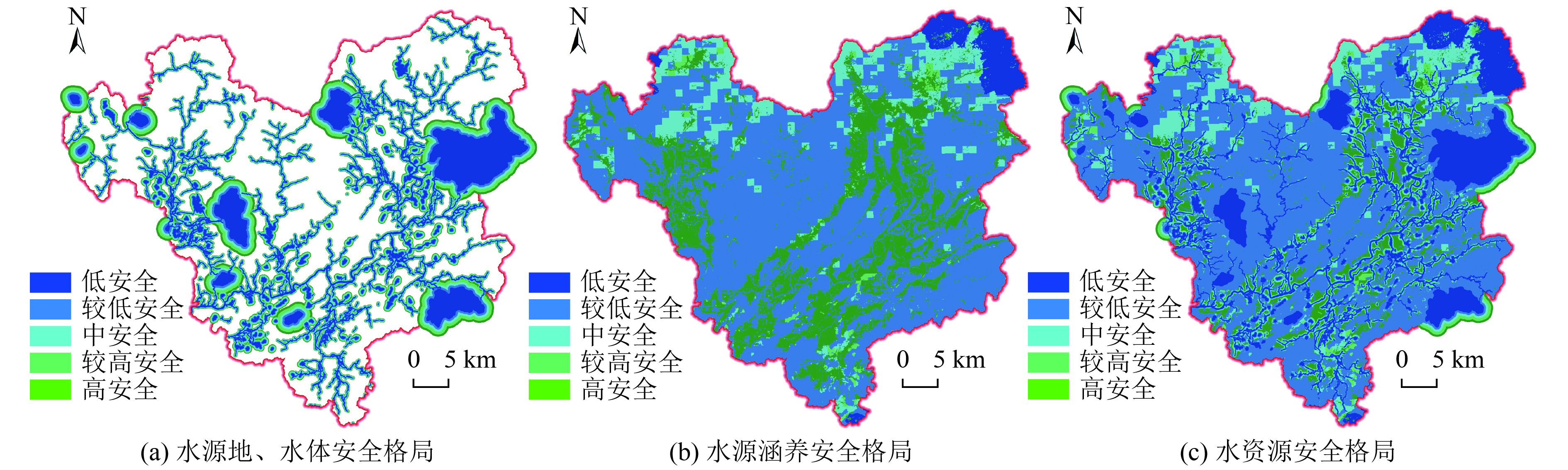
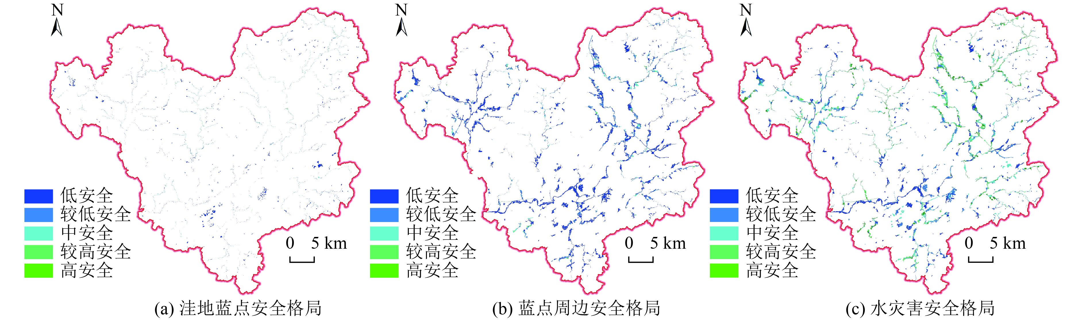
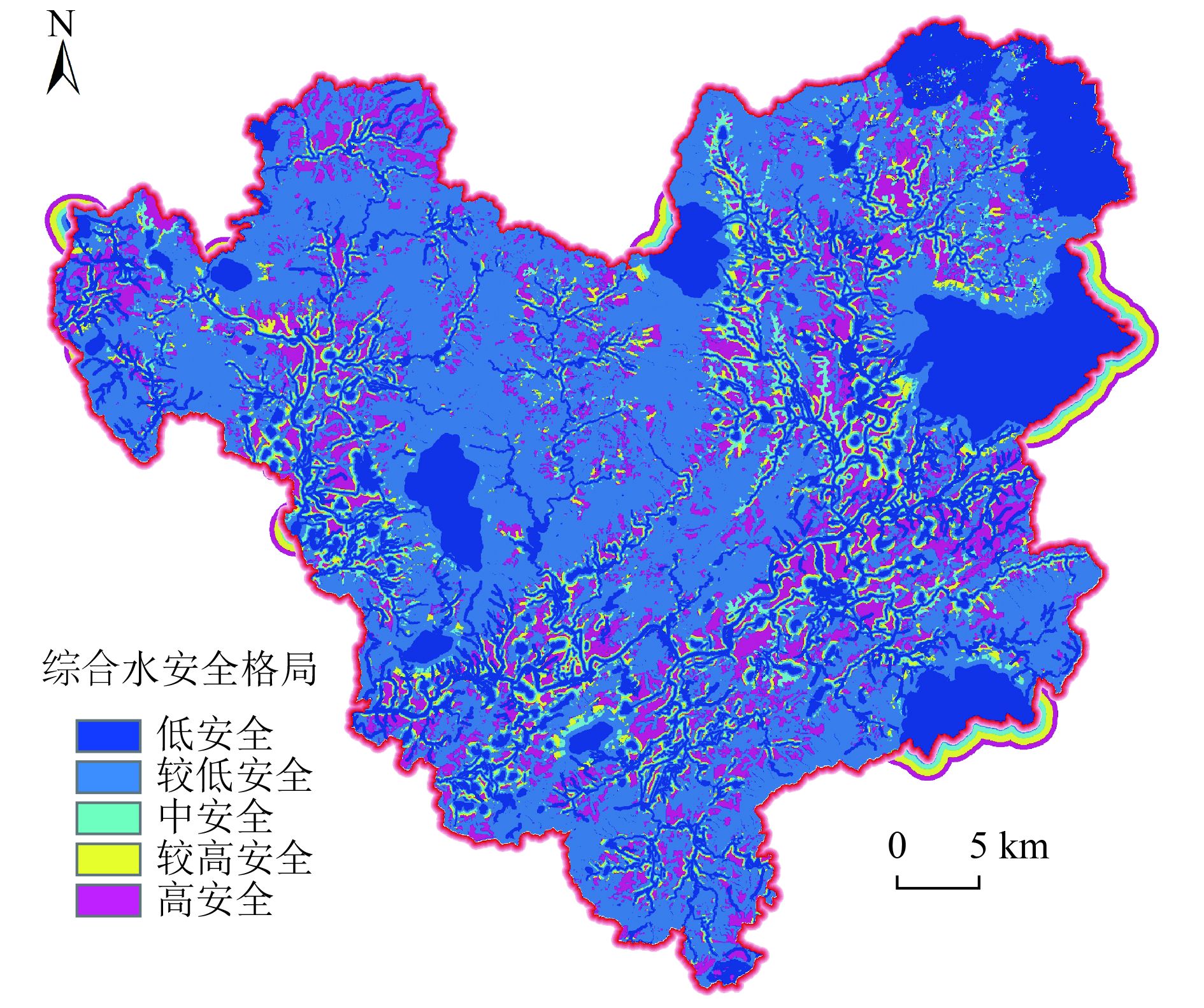
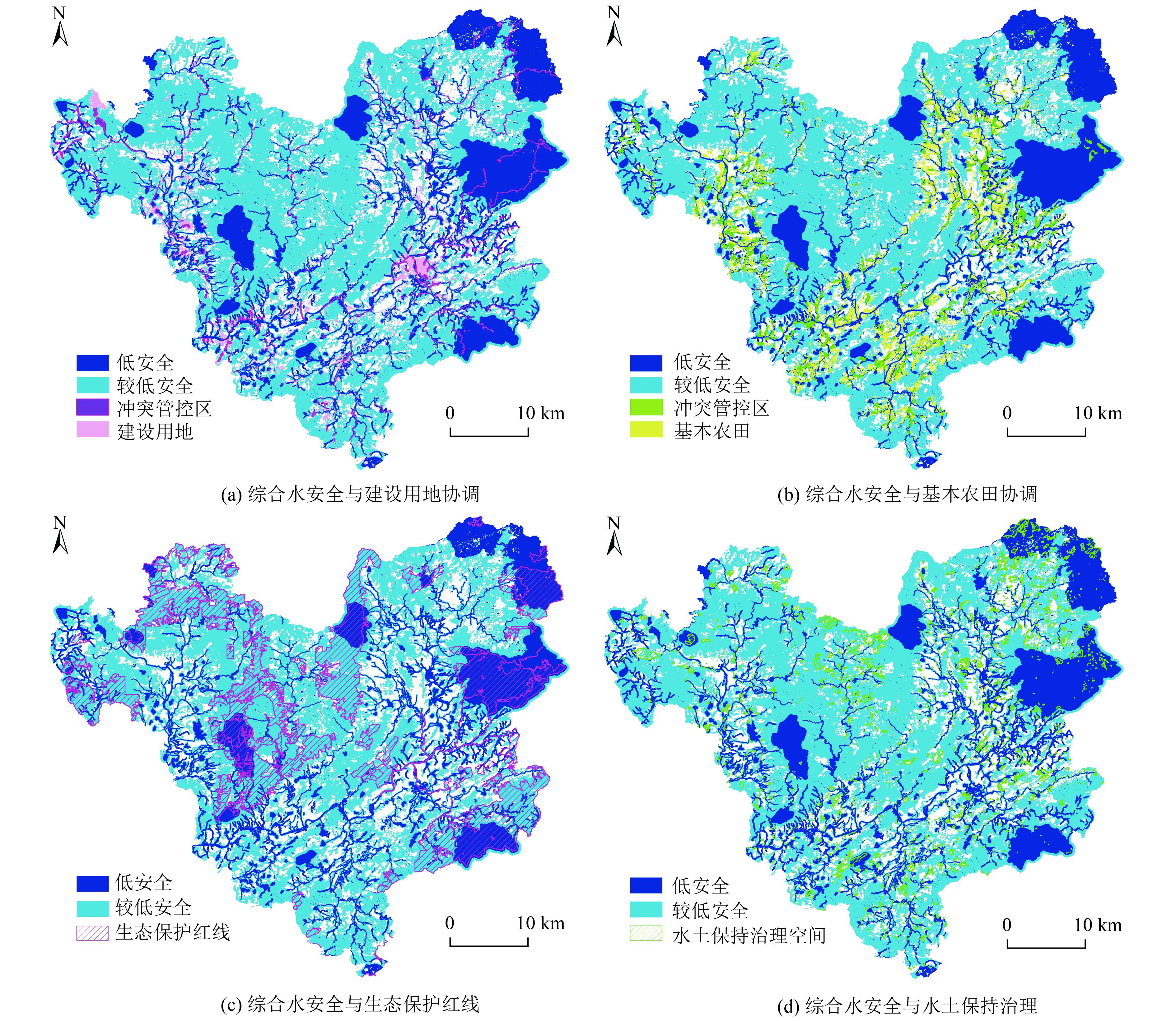
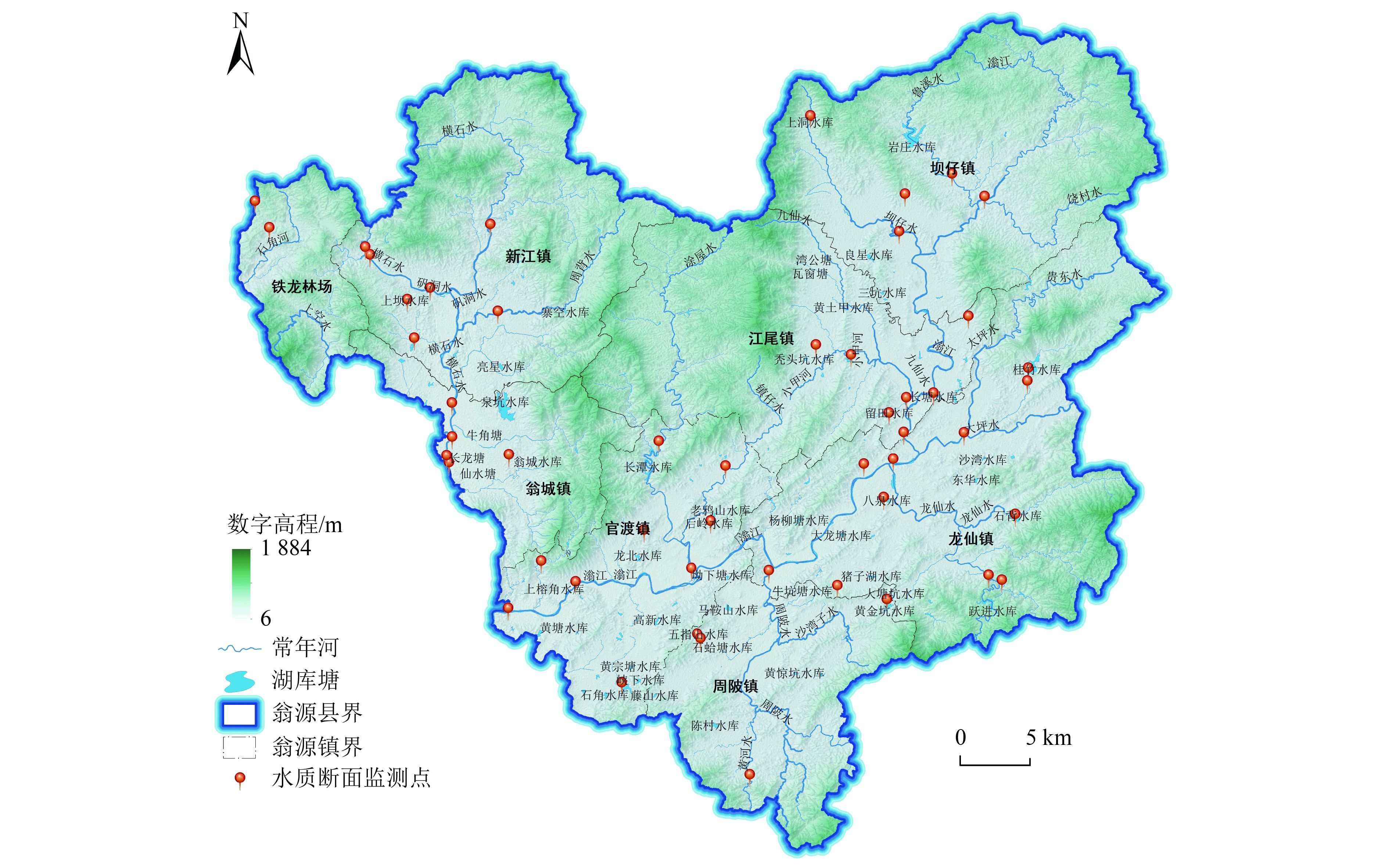
Taking Wengyuan County in the mountainous area of northern Guangdong Province as an example, the authoritative research data sources in the fields of water resources, water hazards and water environment were adopted, combined with data on county topography, hydrology, ecological protection, land status survey, measured water quality sampling, etc., as well as related planning and standards. By using the methods of Euclidean distance buffer for water source combined with conservation capacity calculation, Bluespot model simulation and water environment load calculation, the regional water resources, water hazard and water environment security pattern were calculated and analyzed. On this basis, a comprehensive water security pattern under regional multi-perspectives was constructed. The analysis results showed that the security patterns of water resources, water hazards and water environment in Wengyuan County were closely related to the important water systems and related protected areas and landforms, the location of the upper, middle and lower reaches of Wengjiang River system and the surrounding intensity of human activities, and the pollution status of the water bodies, respectively. The low security areas in the comprehensive water security pattern of Wengyuan County were mainly distributed in ecologically sensitive and fragile areas such as drinking water sources, nature reserves, important water system corridors and water conservation areas and surrounding areas; the medium security areas were mainly distributed in the buffer zone of the low security ecologically sensitive and fragile area, including the adjacent affected area; the high security areas were mainly distributed in the periphery of the medium security buffer zone and its adjacent affected areas. In the comprehensive water security pattern of Wengyuan County, there was a small area conflict control area between the sensitive and fragile low security area and the construction land and permanent basic farmland protection area. However, it had a high degree of agreement with the redline of ecological conservation and the management space of soil and water conservation, which showed that the research results were in good agreement with the space of land management, related protection planning and practical management.

| [1] |
彭建, 赵会娟, 刘焱序, 等.区域水安全格局构建: 研究进展及概念框架[J]. 生态学报,2016,36(11):3137-3145.
PENG J, ZHAO H J, LIU Y X, et al. Progress and conceptual framework of regional water security pattern construction[J]. Acta Ecologica Sinica,2016,36(11):3137-3145.
|
| [2] |
朱军, 李益敏, 余艳红.基于GIS的高原湖泊流域生态安全格局构建及优化研究: 以星云湖流域为例[J]. 长江流域资源与环境,2017,26(8):1237-1250. doi: 10.11870/cjlyzyyhj201708014
ZHU J, LI Y M, YU Y H. Study of construction and optimization of ecological security pattern of lake basin in plateau based on GIS a case study of Xingyun Lake Basin[J]. Resources and Environment in the Yangtze Basin,2017,26(8):1237-1250. doi: 10.11870/cjlyzyyhj201708014
|
| [3] |
张远, 高欣, 林佳宁, 等.流域水生态安全评估方法[J]. 环境科学研究,2016,29(10):1393-1399. doi: 10.13198/j.issn.1001-6929.2016.10.01
ZHANG Y, GAO X, LIN J N, et al. Research on evaluation methods for riverine aquatic ecological security[J]. Research of Environmental Sciences,2016,29(10):1393-1399. doi: 10.13198/j.issn.1001-6929.2016.10.01
|
| [4] |
赵明月, 王文杰, 王维, 等.基于土地利用的水府庙水库流域生态安全评价[J]. 环境工程技术学报,2015,5(1):38-45. doi: 10.3969/j.issn.1674-991X.2015.01.006
ZHAO M Y, WANG W J, WANG W, et al. Ecological security assessment of Shuifumiao reservoir basin based on land use[J]. Journal of Environmental Engineering Technology,2015,5(1):38-45. doi: 10.3969/j.issn.1674-991X.2015.01.006
|
| [5] |
RATNA D P A. Using system dynamic modeling for improving water security in the coastal area: a literature review[J]. Open access Macedonian journal of medical sciences,2020,8(F):143-154.[6 doi: 10.3889/oamjms.2020.4395
|
| [6] |
夏军, 朱一中.水资源安全的度量: 水资源承载力的研究与挑战[J]. 自然资源学报,2002,17(3):262-269. doi: 10.3321/j.issn:1000-3037.2002.03.002
XIA J, ZHU Y Z. The measurement of water resources security: a study and challenge on water resources carrying capacity[J]. Journal of Natural Resources,2002,17(3):262-269. doi: 10.3321/j.issn:1000-3037.2002.03.002
|
| [7] |
张晓岚, 刘昌明, 高媛媛, 等.水资源安全若干问题研究[J]. 中国农村水利水电,2011,9(1):9-13.
ZHANG X L, LIU C M, GAO Y Y, et al. A study of serveral issues concerning water resource security[J]. China Rural Water and Hydropower,2011,9(1):9-13.
|
| [8] |
鲍超, 邹建军.基于人水关系的京津冀城市群水资源安全格局评价[J]. 生态学报,2018,38(12):4180-4191.
BAO C, ZOU J J. Evaluation of water resource security patterns in the Beijing-Tianjin-Hebei urban agglomeration based on human-water relationships[J]. Acta Ecologica Sinica,2018,38(12):4180-4191.
|
| [9] |
樊杰. 资源环境承载能力和国土空间开发适宜性评价方法指南[M]. 北京: 科学出版社, 2019: 108.
|
| [10] |
KNAAPEN J P, SCHEFFER M, HARMS B. Estimating habitat isolation in landscape planning[J]. Landscape and Urban Planning,1992,23(1):1-16. doi: 10.1016/0169-2046(92)90060-D
|
| [11] |
YU K J. Ecological security patterns in landscapes and GIS application[J]. Annals of GIS,1995,1(2):88-102. doi: 10.1080/10824009509480474
|
| [12] |
俞孔坚, 李伟, 李迪华, 等.快速城市化地区遗产廊道适宜性分析方法探讨: 以台州市为例[J]. 地理研究,2005,24(1):69-76. doi: 10.3321/j.issn:1000-0585.2005.01.008
YU K J, LI W, LI D H, et al. Suitability analysis of heritage corridor in rapidly urbanizing region: a case study of Taizhou City[J]. Geographical Research,2005,24(1):69-76. doi: 10.3321/j.issn:1000-0585.2005.01.008
|
| [13] |
袁鹏, 刘瑞霞, 俞洁, 等.《浙江省河流生态缓冲带划定与生态修复技术指南(试行)》解读[J]. 环境工程技术学报,2021,11(1):1-5. doi: 10.12153/j.issn.1674-991X.20210003
YUAN P, LIU R X, YU J, et al. Interpretation of technical guidelines for delineation and ecological restoration of riparian buffers of rivers in Zhejiang Province (Trial)[J]. Journal of Environmental Engineering Technology,2021,11(1):1-5. doi: 10.12153/j.issn.1674-991X.20210003
|
| [14] |
李春华, 叶春, 刘福兴, 等.《浙江省湖库生态缓冲带划定与生态修复技术指南(试行)》解读[J]. 环境工程技术学报,2021,11(1):6-13. doi: 10.12153/j.issn.1674-991X.20210002
LI C H, YE C, LIU F X, et al. Interpretation of Technical Guidelines for Delineation and Ecological Restoration of Ecological Buffers of Lakes and Reservoirs in Zhejiang Province (Trial)[J]. Journal of Environmental Engineering Technology,2021,11(1):6-13. doi: 10.12153/j.issn.1674-991X.20210002
|
| [15] |
侯利萍, 何萍, 钱金平, 等.河岸缓冲带宽度确定方法研究综述[J]. 湿地科学,2012,10(4):500-506. doi: 10.3969/j.issn.1672-5948.2012.04.017
HOU L P, HE P, QIAN J P, et al. A review on determination methods for width of riparian buffer[J]. Wetland Science,2012,10(4):500-506. doi: 10.3969/j.issn.1672-5948.2012.04.017
|
| [16] |
周丽丽, 殷培红, 耿润哲, 等.河岸缓冲带划定及影响因素研究进展[J]. 环境污染与防治,2020,42(8):1044-1048. doi: 10.15985/j.cnki.1001-3865.2020.08.021
ZHOU L L, YIN P H, GENG R Z, et al. A review: riparian buffer zone delineation and the key factors[J]. Environmental Pollution & Control,2020,42(8):1044-1048. doi: 10.15985/j.cnki.1001-3865.2020.08.021
|
| [17] |
彭建, 魏海, 武文欢, 等.基于土地利用变化情景的城市暴雨洪涝灾害风险评估: 以深圳市茅洲河流域为例[J]. 生态学报,2018,38(11):3741-3755.
PENG J, WEI H, WU W H, et al. Storm flood disaster risk assessment in urban area based on the simulation of land use scenarios: a case of Maozhou Watershed in Shenzhen City[J]. Acta Ecologica Sinica,2018,38(11):3741-3755.
|
| [18] |
刘仁义, 刘南.基于GIS的复杂地形洪水淹没区计算方法[J]. 地理学报,2001,56(1):1-6. doi: 10.3321/j.issn:0375-5444.2001.01.001
LIU R Y, LIU N. A GIS based model for calculating of flood area[J]. Acta Geographica Sinica,2001,56(1):1-6. doi: 10.3321/j.issn:0375-5444.2001.01.001
|
| [19] |
乔郭亮, 周寅康, 顾铮鸣, 等.苏南地区景观格局特征与坑塘水质关联关系[J]. 农业工程学报,2021,37(10):224-234. doi: 10.11975/j.issn.1002-6819.2021.10.027
QIAO G L, ZHOU Y K, GU Z M, et al. Analysis of the linkage between landscape pattern and the water quality of ponds in Southern Jiangsu of China[J]. Transactions of the Chinese Society of Agricultural Engineering (Transactions of the CSAE),2021,37(10):224-234. doi: 10.11975/j.issn.1002-6819.2021.10.027
|
| [20] |
李名升, 张建辉, 梁念, 等.常用水环境质量评价方法分析与比较[J]. 地理科学进展,2012,31(5):617-624. doi: 10.11820/dlkxjz.2012.05.010
LI M S, ZHANG J H, LIANG N, et al. Comparisons of some common methods for water environmental quality assessment[J]. Progress in Geography,2012,31(5):617-624. doi: 10.11820/dlkxjz.2012.05.010
|
| [21] |
韦乐章, 邓南荣, 吴志峰, 等.粤北山区地形因素对耕地分布及其动态变化的影响[J]. 山地学报,2008,26(1):76-83. doi: 10.3969/j.issn.1008-2786.2008.01.013
WEI Y Z, DENG N R, WU Z F, et al. Effects of topography on distribution and change of farmland in mountainous area of North Guangdong Province, China[J]. Journal of Mountain Science,2008,26(1):76-83. doi: 10.3969/j.issn.1008-2786.2008.01.013
|
| [22] |
蒋竹荣, 陈流保, 徐锋, 等.广东翁源滃江源国家湿地公园水质调查研究[J]. 林业与环境科学,2020,36(3):24-29.
JIANG Z R, CHEN L B, XU F, et al. Investigation on water quality of Guangdong Wengyuan Wengjiangyuan National Wetland Park[J]. Guangdong Forestry Science and Technology,2020,36(3):24-29.
|
| [23] |
National Meteorological Information Centre. Annual data set of standard values of surface climate in China (1981-2010)[DB/OL]. (2012-08-16)[2022-09-06]. http://data.cma.cn/data/cdcdetail/dataCode/SURF_CLI_CHN_MUL_MYER_19812010.html.
|
| [24] |
JAXA. 12.5 m resolution of ALOS PALSAR topographic data[DB/OL]. (2012-10-31). https://search.asf.alaska.edu/#/.
|
| [25] |
国家基础地理信息中心. 全国地理信息资源目录服务系统 1:25万全国基础地理数据库[DB/OL]. (2017-12-18)[2022-09-06]. https://www.webmap.cn/commres.do?method=result25W.
|
| [26] |
LEHNER B, GRILL G. Global river hydrography and network routing: baseline data and new approaches to study the world's large river systems[J]. Hydrological Processes,2013,27(15):2171-2186. doi: 10.1002/hyp.9740
|
| [27] |
孙英彪, 哈凯, 门明新.CACE模型及其在生态安全格局优化中的应用[J]. 农业工程学报,2016,32(23):269-277. doi: 10.11975/j.issn.1002-6819.2016.23.037
SUN Y B, HA K, MEN M X. CACE model and its application in optimization of ecological security pattern[J]. Transactions of the Chinese Society of Agricultural Engineering (Transactions of the CSAE),2016,32(23):269-277. doi: 10.11975/j.issn.1002-6819.2016.23.037
|
| [28] |
XIAO S, WU W, GUO J, et al. An evaluation framework for designing ecological security patterns and prioritizing ecological corridors: application in Jiangsu Province, China[J]. Landscape Ecology,2020,35(11):2517-2534. doi: 10.1007/s10980-020-01113-6
|
| [29] |
BABY S N, ARROWSMITH C, LIU G, et al. Finding areas at risk from floods in a downpour using the Lidar-based elevation model[J]. Journal of Civil Engineering and Architecture,2021,15(1):1-16.
|
| [30] |
JAYAPRAKASH S, JAYATHILAKE D, MUNASINGHE D S. Study on flood inundation areas in Rathnapura Municipal Council[C]//Risk Awareness and Future Challenges. Colombo: NBRO International Symposium, 2016.
|
| [31] |
ESRI Learn ArcGIS. Model bluespots to map flood risk[EB/OL]. (2021-11-29)[2022-10-10]. https://learn.arcgis.com/zh-cn/projects/find-areas-at-risk-of-flooding-in-a-cloudburst/.
|
| [32] |
卢玉成, 宋佩珊, 黄文暖, 等.基于AHP层次分析法“三线一单”水环境管控分区的研究: 以东莞市松山湖为例[J]. 环境科学与管理,2022,47(7):26-31. doi: 10.3969/j.issn.1673-1212.2022.07.008
LU Y C, SONG P S, HUANG W N, et al. Study on water environment management and control zoning in "Three Lines and One List" based on AHP: a case study of Songshan Lake in Dongguan City[J]. Environmental Science and Management,2022,47(7):26-31. doi: 10.3969/j.issn.1673-1212.2022.07.008
|
| [33] |
张媛媛, 卢荣旺, 唐波, 等.贫困地区生态-经济系统脆弱性时空格局及障碍度研究: 以粤北韶关市8县为例[J]. 生态经济,2021,37(8):213-220.
ZHANG Y Y, LU R W, TANG B, et al. Study on the vulnerability of ecological-economic system and obstacles in the poor areas of northern Guangdong: taking 8 counties of Shaoguan City as an example[J]. Ecological Economy,2021,37(8):213-220.
|
| [34] |
刘庆才, 吴飞.粤北工业园区水土流失及其防治对策[J]. 亚热带水土保持,2010,22(1):76-78. doi: 10.3969/j.issn.1002-2651.2010.01.026
LIU Q C, WU F. Soil erosion and its prevention and control measures in industrial parks in northern Guangdong[J]. Subtropical Soil and Water Conservation,2010,22(1):76-78. doi: 10.3969/j.issn.1002-2651.2010.01.026
|
| [35] |
沈明, 陈飞香, 苏少青, 等.省级高标准基本农田建设重点区域划定方法研究: 基于广东省的实证分析[J]. 中国土地科学,2012,26(7):28-33. doi: 10.3969/j.issn.1001-8158.2012.07.006
SHEN M, CHEN F X, SU S Q, et al. Approach to determining the key areas for provincial high-standard primary farmland development: based on Guangdong province[J]. China Land Sciences,2012,26(7):28-33. doi: 10.3969/j.issn.1001-8158.2012.07.006
|
| [36] |
吴耀龙, 张池, 陈旭飞.水田垦造中土壤有机质的提升及pH调整研究[J]. 国土资源科技管理,2020,37(4):37-45.
WU Y L, ZHANG C, CHEN X F. Study on soil organic matter increment and pH adjustment during the reclamation process of paddy fields[J]. Scientific and Technological Management of Land and Resources,2020,37(4):37-45. ⊕
|
Figures(6) / Tables(2)
Copyright © Editorial Department of Journal of Environmental Engineering Technology
Supported by: Beijing Renhe Information Technology Co., Ltd.


 DownLoad: